
Soil/Landform Unit 44
Landform Unit Description
Page top
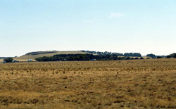 The moderately inclined low cone near Mount Mercer has a level top with steep slopes exposing basalt and scoria |
<0.01% of CMA region The moderately inclined low cone south of Mount Mercer forms part of a sequence of volcanic landforms within the Midlands of the Western Uplands. This cone comprises a cone crest and upper, mid or lower slopes. This cone has had all native vegetation removed and replaced with perennial and annual pastures. The upper/ mid slopes and crests support shallow red friable texture contrast and/or gradational soils, while the lower slopes host black self-mulching clays. The land use is mainly grazing with minor cropping on the lower slopes. Erosion hazards are minimal. Areas with shallow stony gradational soils are susceptible to leaching of nutrients, and compaction is a problem on the lower slopes with the self-mulching soils. |  |
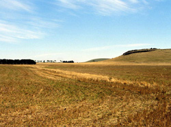 The lower slopes and neighbouring unit are mainly used for cropping | 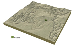 |
|
Component | 1 | 2 | 3 |
Proportion of soil-landform unit | 25% | 30% | 45% |
| CLIMATE Rainfall (mm) | Annual: 670 | ||
| Temperature (oC) | Minimum 7; Maximum 18 | ||
| Precipitation less than potential evapotranspiration | October-March | ||
| GEOLOGY Age and lithology | |||
| Geomorphology | |||
| LANDUSE | Uncleared: Nature conservation; passive and active recreation; water supply; hardwood forestry Cleared: Beef cattle and sheep grazing; cropping; residential development; horticulture | ||
| TOPOGRAPHY Landscape | Moderatelyinclined low cones | ||
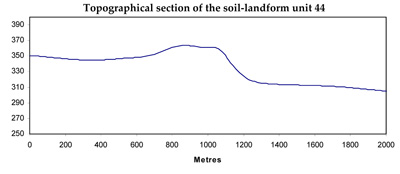
| Elevation range (m) | 313-363 | ||
| Local relief (m) | 40 | ||
| Drainage pattern | Dendritic | ||
| Drainage density (km/km2) | 0.3 | ||
| Landform | Volcanic cone | ||
| Landform element | Broad creast and gentle upper slopes | Steep mid and upper slopes | Lower slopes |
| Slope and range (%) | 3 (1-7) | 6 (3-15) | 3 (1-8) |
| Slope shape | Convex | Concave-Convex | Concave |
| NATIVE VEGETATION Ecological Vegetation Class | Absent | ||
| SOIL Parent material | Basalt and scoria | Basalt and scoria | Basalt and scoria |
| Description (Corangamite Soil Group) | Shallow black self-mulching soils (39) | ||
| Soil type sites | SW102, SW101, SW103 | ||
| Surface texture | Loams | Loams | Clays |
| Permeability | High | High | High |
| Depth (m) | <0.7 | <1 | <1 |
| LAND CHARACTERISTICS, POTENTIAL AND LIMITATIONS | Texture contrast soils with low water holding capacity, moderate nutrient holding capacity in upper soil, high in subsoil. Gradational soils tend to have low to moderate water holding capacity, moderate to high nutrient holding capacity. Shallow to moderately deep, friable and some stone. Moderately rapid site drainage with slight susceptibility to sheet erosion. | Texture contrast, low water holding capacity, moderate nutrient holding capacity in upper soil, high in subsoil. Gradational soils tend to have low to moderate water holding capacity, moderate to high nutrient holding capacity. Shallow to moderately deep, friable and often stony soils. Rapid site drainage with slight susceptibility to sheet erosion. | Uniform expansive clays with high water holding capacity, very high nutrient holding capacity. Shallow to moderate deep, friable and self-mulching soils that are often stony. Moderate site drainage with slight susceptibility to sheet erosion. |
© State of Victoria (Agriculture Victoria) 1996 - .

This work, Victorian Resources Online, is licensed under a Creative Commons Attribution 4.0 licence. You are free to re-use the work under that licence, on the condition that you credit the State of Victoria (Agriculture Victoria) as author, indicate if changes were made and comply with the other licence terms.
The licence does not apply to ‘branding’ or some ‘images or photographs’ that may be owned by third parties. We ask you to seek prior approval to use images using the VRO feedback form. Access to higher quality images can also be provided on request.
This page was last updated on .