
Soil/Landform Unit 31
Landform Unit Description
Page top
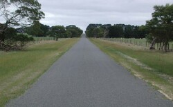 Looking north on Mt Mercer-Horsehill West Road towards the crest of this low hill |
0.01% of CMA region This unit is a low hill that has developed on Quaternary basalt and constitutes one of many volcanic landforms within the Midlands of the Western Uplands. The undulating hillslopes have little remnant vegetation with less than 1.5% Plains Grassy Woodland. The soils of the middle and lower slopes are relatively poorly drained texture contrast soils with a shallow surface horizon over sodic medium to heavy clay subsoils. On the upper slopes and crest, the profile depths tend to be shallow owing to the underlying basalt. The land use is extensively grazing (mainly sheep) rather than cropping, being subject to waterlogging. Sheet and rill erosion is minor on these undulating hillslopes. |  |
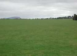 Long gentle slopes of this low hill near Cargerie | 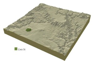 |
|
Component | 1 | 2 | 3 |
Proportion of soil-landform unit | 95% | 3% | 2% |
| CLIMATE Rainfall (mm) | Annual: 670 | ||
| Temperature (oC) | Minimum 7, Maximum 18 | ||
| Precipitation less than potential evapotranspiration | October-March | ||
| GEOLOGY Age and lithology | Pleistocene, basalt | ||
| Geomorphology | |||
| LANDUSE | Uncleared: Nature conservation Cleared: Sheep and beef cattle grazing; cropping (cereal) | ||
| TOPOGRAPHY Landscape | Extensive, slightly dissected plains | ||
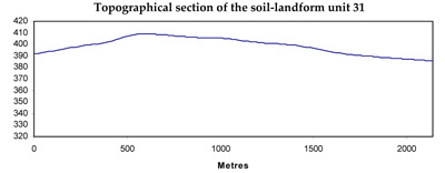
| Elevation range (m) | 386-412 | ||
| Local relief (m) | 2 | ||
| Drainage pattern | Dendritic | ||
| Drainage density (km/km2) | 0.8 | ||
| Landform | Depression | ||
| Landform element | Long gentle upper slopes | Depression | Stony rise |
| Slope and range (%) | 4 (1-10) | 1 (1-2) | 3 (2-5) |
| Slope shape | Straight | Straight | Convex |
| NATIVE VEGETATION Ecological Vegetation Class | Plains Grassy Woodland (1.4%) | ||
| Dominant species | E. ovata, E. viminalis, E. rubidia, E. obliqua | ||
| SOIL Parent material | In situ weathered basalt | Alluvium | In situ weathered basalt |
| Description (Corangamite Soil Group) | Black clay soil, coarse structure (31) | Red shallow, stony gradational soil (40) | |
| Soil type sites | |||
| Surface texture | Clay loam | Clay | Clay loam |
| Permeability | Moderate to low | Moderate | High |
| Depth (m) | 1.5 | 1.5 | 0.5 |
| LAND CHARACTERISTICS, POTENTIAL AND LIMITATIONS | Hardsetting surfaces and slowly permeable subsoils result in significant overland flow. Sheet and rill erosion also occur from this overland flow. Soil compaction is also a limitation for soils with shallow topsoils. Periodic waterlogging also occurs. | Clay soils beside creeks are prone to periodic waterlogging. Streambank undercutting and stream bank erosion common. Slowly permeable subsoils are also quite sodic and prone to gully erosion. | Overland flow, nutrient leaching and decline all reflect highly permeable soils. Sheet erosion is common with excessive rainfall events. |
© State of Victoria (Agriculture Victoria) 1996 - .

This work, Victorian Resources Online, is licensed under a Creative Commons Attribution 4.0 licence. You are free to re-use the work under that licence, on the condition that you credit the State of Victoria (Agriculture Victoria) as author, indicate if changes were made and comply with the other licence terms.
The licence does not apply to ‘branding’ or some ‘images or photographs’ that may be owned by third parties. We ask you to seek prior approval to use images using the VRO feedback form. Access to higher quality images can also be provided on request.
This page was last updated on .