
Soil/Landform Unit 30
Landform Unit Description
Page top
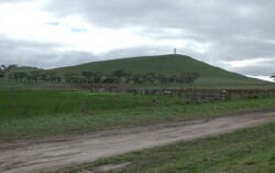 Mount Anakie with steep southern slopes |
0.04% of CMA region Mount Anakie is a steep high cone located at the southern extremity of the Midlands. This cone represents one of a suite of eruption points across the Western Uplands. With steep slopes and gentler lower slopes, this cones has little (approximately 5%) remnant vegetation with the major vegetation classes being Herb-rich Woodland, Plains Grassy Woodland and Scoria Cone Woodland. These remnants occur mainly as reserves on upper slopes and crests, and footslopes. These cones have highly fertile side slopes and footslopes that have been used for cereal production and grazing. The basaltic rock and scoria support shallow friable red duplex and gradational soils on the relatively steeper middle and upper slopes. The gentler lower slopes contain patches of shallow black self-mulching clay. Overland flow is likely on the steeper slopes. Nutrient leaching and decline are possible due to the shallow and permeable nature of gradational soils. |  |
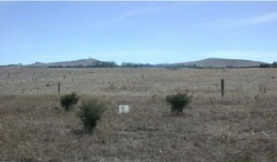
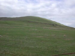 Steep slopes of Mount Anakie are mainly used for grazing due to high level of surface stone | 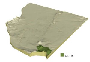 |
|  Looking towards Mount Anakie over teh neighbouring basalt plains |
Component | 1 | 2 | 3 | 4 |
Proportion of soil-landform unit | 10% | 18% | 27% | 45% |
| CLIMATE Rainfall (mm) | Annual: 640 | |||
| Temperature (oC) | Minimum 8, Maximum 19 | |||
| Precipitation less than potential evapotranspiration | October-April | |||
| GEOLOGY Age and lithology | Quaternary basalt and scoria | |||
| Geomorphology | ||||
| LANDUSE | Uncleared: Nature conservation; water supply Cleared: Cropping (cereal); sheep and beef cattle grazing | |||
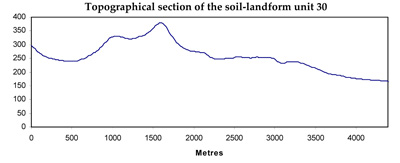
| TOPOGRAPHY Landscape | Steep, high cone of Mount Anakie | |||
| Elevation range (m) | 190-389 | |||
| Local relief (m) | 200 | |||
| Drainage pattern | Dendritic | |||
| Drainage density (km/km2) | 0.6 | |||
| Landform | Cone hill | |||
| Landform element | Crest | Steep upper slope | Steep mid slope | Gentle lower slope |
| Slope and range (%) | 3 (1-8) | 14 (5-25) | 10 (5-15) | 5 (3-12) |
| Slope shape | Convex | Convex | Convex | Concave |
| NATIVE VEGETATION Ecological Vegetation Class | Hills Herb-rich Woodland (2%), Plains Grassy Woodland (1.4%), Scoria Cone Woodland (1.4%) | |||
| SOIL Parent material | In situ basalt and scoria | In situ basalt and scoria | In situ basalt and scoria | In situ basalt and scoria |
| Description (Corangamite Soil Group) | ||||
| Soil type sites | ||||
| Surface texture | Loam | Loam | Clay loam | Clay loam, light clay |
| Permeability | High | High to very high | High | Moderate to high |
| Depth (m) | <0.6 | <0.7 | <1 | <1 |
| LAND CHARACTERISTICS, POTENTIAL AND LIMITATIONS | Shallow, friable, texture contrast or gradational soils with moderate to high nutrient holding capacity, low to moderate water holding capacity. Highly permeable resulting in rapid site drainage. | Shallow, friable, texture contrast or gradational; moderate to high nutrient holding capacity, low to moderate water holding capacity. High permeable. High permeable resulting in rapid site drainage. Rolling slopes are prone to slight sheet erosion. | Shallow to moderately deep, friable, texture contrast or gradational soils, moderate to high nutrient holding capacity, moerate water holding capacity. Highly permeable resulting in rapid site drainage. Rolling slopes are prone to slight sheet erosion. | Shallow to moderately deep, friable, texture contrast or gradational soils, moderate to high nutrient holding capacity, moderate water holding capacity. Moderately to highly permeable resulting in moderately rapid site drainage. Undulating slopes may be prone to slight sheet and rill erosion. |
© State of Victoria (Agriculture Victoria) 1996 - .

This work, Victorian Resources Online, is licensed under a Creative Commons Attribution 4.0 licence. You are free to re-use the work under that licence, on the condition that you credit the State of Victoria (Agriculture Victoria) as author, indicate if changes were made and comply with the other licence terms.
The licence does not apply to ‘branding’ or some ‘images or photographs’ that may be owned by third parties. We ask you to seek prior approval to use images using the VRO feedback form. Access to higher quality images can also be provided on request.
This page was last updated on .