
Soil/Landform Unit 27
Landform Unit Description
Page top
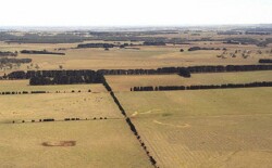 Undulating low hills and plains north-west of Meredith |
0.24% of CMA region The undulating low hills in the area of the Bamganie State Forest near Meredith are composed of Neogene fluvio-marine sand, and Ordovician marine sandstone and shale. The hillslopes support a wide range of vegetation classes including Creekline Herbrich Woodland, Lowland Forest and Grassy Dry Forest. Dominant species are Eucalyptus viminalis, E. obliqua, E. radiata, E. rubidia, E. ovata and E. pauciflora. The low fertility and the low water holding capacity of the soils have discouraged further clearing, except on some of the gentler, lower slopes that support native pastures. Soils include an association of sandy mottled texture contrast soils with structured or massive subsoils that occur on the hillslopes with sandy equivalents occurring on upper slopes. These soils can be prone to gully erosion which is minor to moderate in severity in some cleared areas. |  |
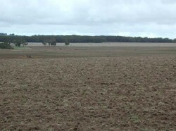 Plains leading to remnant vegetation lining Woodburne | 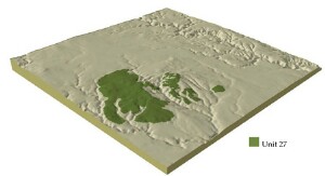 |
| 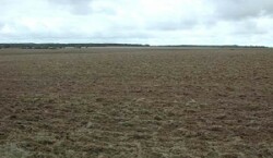 Cultivated plains near Woodbourne |
Component | 1 | 2 | 3 | 4 |
Proportion of soil-landform unit | 70% | 2% | 15% | 13% |
| CLIMATE Rainfall (mm) | Annual: 670 | |||
| Temperature (oC) | Minimum 8, Maximum 18 | |||
| Precipitation less than potential evapotranspiration | October-March | |||
| GEOLOGY Age and lithology | Neogene fluvio-marine sand, Ordovician marine sandstone and shale | |||
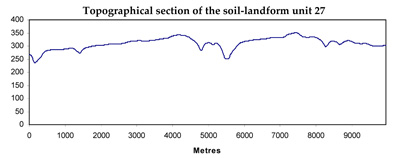
| Geomorphology | ||||
| LANDUSE | Uncleared: Nature conservation; firewood and sawlogs | |||
| TOPOGRAPHY Landscape | Cleared: Grazing; gravel extraction; mining | |||
| Elevation range (m) | Plains | |||
| Local relief (m) | 236-371 | |||
| Drainage pattern | 3 | |||
| Drainage density (km/km2) | Dendritic | |||
| Landform | 0.8 | |||
| Landform element | Undulating plains | Flat plains | Drainage lines | |
| Slope and range (%) | Well drained non-sandy areas | Patches of deep sandy soil | Poorly drained non-sandy areas | Low-lying areas |
| Slope shape | 1 (1-3) | 1 (1-3) | 0 (0-2) | 1 (1-3) |
| NATIVE VEGETATION Ecological Vegetation Class | Creekline Herb-rich Woodland (3.5%), Lowland Forest (3.5%), Grassy Dry Forest (3.4%) | |||
| Dominant species | E. viminalis, E. obliqua, E. rubidia, E. ovata, E. pauciflora | Pteridium esculentum, E. viminalis | E. ovata | E. ovata |
| SOIL Parent material | Unconsolidated gravel, sand and clay | Unconsolidated sand | Unconsolidated gravel, sand and clay | Unconsolidated gravel, sand and clay |
| Description (Corangamite Soil Group) | Yellow sand soil (16) | Mottled brown, grey or yellow texture contrast soil (33) | ||
| Soil type sites | ||||
| Surface texture | Sandy clay loam to loamy sand | Sand | Clay loam | Clay loam, sandy clay loam |
| Permeability | Moderate | High | Low | Moderate |
| Depth (m) | 2 | 2 | 2 | 2 |
| LAND CHARACTERISTICS, POTENTIAL AND LIMITATIONS | Hardsetting surfaces result in significant overland flow. Sheet and rill erosion also occur from this overland flow with leaching of salts. Gully erosion occurs mainly where sodic subsoils are exposed. | Low water and nutrient holding capacity lead to fertility decline. | Hardsetting surfaces result in significant overland flow. Sheet and rill erosion also occur from this overland flow with leaching of salts. Gully erosion occurs mainly where sodic subsoils are exposed. | Hardsetting surfaces result in significant overland flow. Sheet and rill erosion also occur from this overland flow with leaching of salts. Gully erosion occurs mainly where sodic subsoils are exposed. Salting occurs especially when adjacent to Ordovician sediments |
© State of Victoria (Agriculture Victoria) 1996 - .

This work, Victorian Resources Online, is licensed under a Creative Commons Attribution 4.0 licence. You are free to re-use the work under that licence, on the condition that you credit the State of Victoria (Agriculture Victoria) as author, indicate if changes were made and comply with the other licence terms.
The licence does not apply to ‘branding’ or some ‘images or photographs’ that may be owned by third parties. We ask you to seek prior approval to use images using the VRO feedback form. Access to higher quality images can also be provided on request.
This page was last updated on .