
Soil/Landform Unit 202
Landform Unit Description
Page top
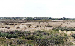 Tidal swamps lie just inland from the coastal dunes and provide valuable habitats for wildlife |
0.04% of CMA region Many of the outlets of creeks and rivers to the east of the Otway Range possess tidal swamps with braided channels and brackish lagoons. Thompson Creek and Painkalac Creek have such river mouths, although the most extensive swamp lies just outside the present study area, surrounding the mouth of the Barwon River. Only minor differences in height above mean tide level determine the differences between the land components. The marine terraces escape inundation in all but extremely rare combinations of floods and high tide, while most other tracts of land are flooded either regularly or irregularly. Halophytic shrubs and herbs colonise the grey and structureless silty clays found on these swamps. The structure and species of each community are strongly influenced by the height above mean tide level and the degree of salinity of the tidal water. Some parts of these areas have been drained or filled to provide for agriculture or recreational facilities. However, most parts remain in their natural state. | 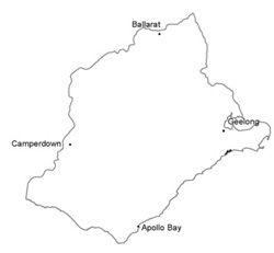 |
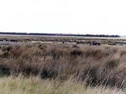 Swamp east of Torquay | 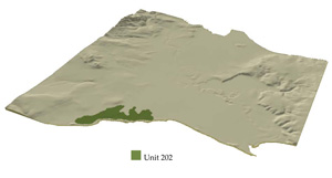 |
 |
Component | 1 | 2 | 3 | 4 | 5 |
Proportion of soil-landform unit | 30% | 30% | 10% | 15% | 15% |
| CLIMATE Rainfall (mm) | Annual: 625, lowest January (30), highest August (60) | ||||
| Temperature (oC) | Annual: 14, lowest July (10), highest February (18) | ||||
| Seasonal growth limitations | Temperature: less than l 0oC (av.) July Precipitation: less than potential evapotranspiration October–early April | ||||
| GEOLOGY Age and lithology | Recent estuarine sand, silt, clay and plant remains | Veneer of aeolian sand | |||
| Geomorphology | |||||
| LANDUSE | Cleared areas: Some of the higher areas cleared for grazing, cropping and recreational Uncleared areas: Nature conservation; refuse disposal facilities | ||||
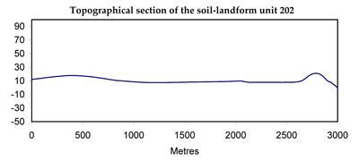
| TOPOGRAPHY Landscape | Flat estuarine lowlands with braided channels | ||||
| Elevation range (m) | 0–4 | ||||
| Local relief (m) | 1 | ||||
| Drainage pattern | Deranged | ||||
| Drainage density (km/km2) | 4.6 | ||||
| Landform | Marine terraces | Swamps | |||
| Landform element | - | Upper surface occasionally inundated | Lower surface regularly inundated | Free water surface | Area adjacent to sand dune |
| Slope and range (%) | 1 (0–2) | 0 (0–1) | 0 | 1 (0–2) | |
| Slope shape | Convex | Linear | Linear | Irregular | |
| NATIVE VEGETATION Structure | (Not known) | Low shrubland | Closed grassland | - | Sedgeland |
| Dominant species | - | Arthrocnemum arbusculum, Gahnia filum | Frankenia pauciflora, Samolus repens, Arthrocnemum arbusculum | - | Scirpus nodosus |
| SOIL Parent material | Estuarine clay, silt and sand | Estuarine clay, silt and plant remains | Estuarine clay, silt and plant remains | Estuarine clay, silt and plant remains | Aeolian sand, shell grit over estuarine clay, silt and plant remains |
| Description (Corangamite Soil Group) | Brown, grey or yellow sodic texture contrast soils (32) | Saline soils (12) | Saline soils (12) | Saline soils (12) | Grey sand soils, weakly structured clay underlay (12) |
| Soil type sites | CLRA34, CLRA44 | CLRA34, CLRA44 | CLRA34, CLRA44 | OTR737 | |
| Surface texture | Sandy loam | Silty clay loam | Silty clay | Silty clay | Sandy loam |
| Permeability | Moderate | Very low | Very low | Very low | Low |
| Depth (m) | >2 | >2 | >2 | >2 | >2 |
| LAND CHARACTERISTICS, POTENTIAL AND LIMITATIONS | Sodic subsoils with high saline groundwater tables are prone to soil salting, surface compaction and sheet erosion. | Occasional influx of estuarine saline water on clays of low mechanical strength leads to soil salting and compaction. | Regular influx of estuarine saline water on clays of low mechanical strength leads to soil salting and compaction. | Minor hazards. | Sodic subsoils with low permeability and high saline groundwater tables are prone to surface compaction and soil salting. |
© State of Victoria (Agriculture Victoria) 1996 - .

This work, Victorian Resources Online, is licensed under a Creative Commons Attribution 4.0 licence. You are free to re-use the work under that licence, on the condition that you credit the State of Victoria (Agriculture Victoria) as author, indicate if changes were made and comply with the other licence terms.
The licence does not apply to ‘branding’ or some ‘images or photographs’ that may be owned by third parties. We ask you to seek prior approval to use images using the VRO feedback form. Access to higher quality images can also be provided on request.
This page was last updated on .