
Soil/Landform Unit 183
Landform Unit Description
Page top
 Near-level plains south of Lake Gnarpurt |
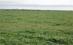
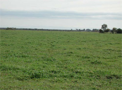
0.03 % of CMA region This small singular unit with a sole component occurs south of Lake Gnarpurt and on the north-western shore of Lake Corangamite, with near-level sedimentary plains to the south (Unit 188). Land here has been extensively cleared with no remnant vegetation. The soils are alkaline (strongly sodic) mottled black texture contrast soils (Sodosols). Given the locality and topographic position, this unit is highly susceptible to waterlogging and compaction. Nutrient decline in the upper soil and structure decline (with increasing sodicity) are also concerns. Some surface soils may be friable. |  |
 Wind erosion, waterlogging and compaction are the main degradation threats to this unit | 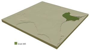 |
 |
Component | 1 |
Proportion of soil-landform unit | 100% |
| CLIMATE Rainfall (mm) | Annual: 590 |
| Temperature (oC) | Minimum 8, Maximum 19 |
| Precipitation less than potential evapotranspiration | October–March |
| GEOLOGY Age and lithology | Neogene fluvial-marine sediments, Quaternary coastal sand dunes |
| Geomorphology | |
| LANDUSE | Uncleared: Nature conservation Cleared areas: Sheep and beef cattle grazing; water supply; cropping (cereal) in dry seasons |
| TOPOGRAPHY Landscape | Level plains |
| Elevation range (m) | 113–128 |
| Local relief (m) | 1–2 |
| Drainage pattern | Centripetal |
| Drainage density (km/km2) | 1.1 |
| Landform | |
| Landform element | Plains |
| Slope and range (%) | 0 (0–1) |
| Slope shape | Straight |
| NATIVE VEGETATION Ecological Vegetation Class | Plains Grassland / Plains Grassy Woodland Mosaic (0.4%), Grassy Woodland (0.3%), Swamp Scrub (0.1%) |
| SOIL Parent material | Sand, clay and gravel |
| Description (Corangamite Soil Group) | |
| Soil type sites | |
| Surface texture | Clay loam |
| Permeability | Low |
| Depth (m) | <2 |
| LAND CHARACTERISTICS, POTENTIAL AND LIMITATIONS | Texture contrast, low nutrient holding capacity and water holding capacity in subsurface and surface soil, higher in subsoil. Acidic (not quite strongly). Heavy, possibly expansive clay subsoil. Slow site drainage, susceptible to waterlogging and compaction. |
© State of Victoria (Agriculture Victoria) 1996 - .

This work, Victorian Resources Online, is licensed under a Creative Commons Attribution 4.0 licence. You are free to re-use the work under that licence, on the condition that you credit the State of Victoria (Agriculture Victoria) as author, indicate if changes were made and comply with the other licence terms.
The licence does not apply to ‘branding’ or some ‘images or photographs’ that may be owned by third parties. We ask you to seek prior approval to use images using the VRO feedback form. Access to higher quality images can also be provided on request.
This page was last updated on .