
Soil/Landform Unit 179
Landform Unit Description
Page top
 Soils are derived from Quaternary volcanics with influence from surrounding granite and sedimentary hills. The soils are likely to experience soil compaction without controlled traffic and organic matter inputs into the topsoil |
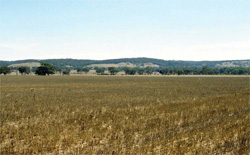
0.05% of CMA region The gently undulating plains on Quaternary basalt occur near Anakie. Much of the land has been cleared with Plains Grassy Woodland and Creekline Grassy Woodland the dominant vegetation classes. Land use is mainly cropping (cereal) and grazing. Soils are typically alkaline mottled brown texture contrast in nature. While waterlogging is a minor limitation (dependent upon season and rainfall), soil compaction is a limitation for production of soils with shallow topsoils. |  |
 Cropping and grazing are the major land uses of these fertile plains near Anakie | 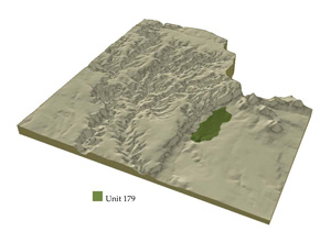 |
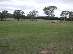
 | 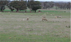 Sheep grazing on the undulating plains near Anakie |
Component | 1 | 2 |
Proportion of soil-landform unit | 85% | 15% |
| CLIMATE Rainfall (mm) | Annual: 640 | |
| Temperature (oC) | Minimum 8, Maximum 19 | |
| Precipitation less than potential evapotranspiration | October–April | |
| GEOLOGY Age and lithology | Quaternary basalt, minor Devonian granite | |
| Geomorphology | ||
| LANDUSE | Uncleared areas: Water supply; nature conservation Cleared areas: Sheep and beef cattle grazing; cropping (cereal); water supply | |
| TOPOGRAPHY Landscape | Gently undulating plains | |
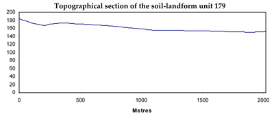
| Elevation range (m) | 108–195 | |
| Local relief (m) | 3 | |
| Drainage pattern | Dendritic | |
| Drainage density (km/km2) | 2.0 | |
| Landform | Plain | |
| Landform element | Gentle plain | Drainage depression/line |
| Slope and range (%) | 2 (1–4) | 1 (0–3) |
| Slope shape | Straight | Convex |
| NATIVE VEGETATION Ecological Vegetation Class | Plains Grassy Woodland (5.2%), Creekline Grassy Woodland (0.2%) | |
| SOIL Parent material | Volcanic silt and gravel | Clay and silt |
| Description (Corangamite Soil Group) | Mottled brown texture contrast soils (36) | Grey and brown gradational soils (31) |
| Soil type sites | ||
| Surface texture | Fine sandy loam | Loam to light clay |
| Permeability | Low | Very low |
| Depth (m) | >2 | >2 |
| LAND CHARACTERISTICS, POTENTIAL AND LIMITATIONS | Slowly permeable soils and hardsetting surfaces result in overland flow and waterlogging. Soil compaction is also a limitation for soils with shallow topsoils. | Moderate to high nutrient holding capacity in upper soil, high in subsoil. Moderate to high water holding capacity, moderately deep to deep soil. Very low permeability. Strongly sodic in subsoil. Expansive clay soils, very slow site drainage. |
© State of Victoria (Agriculture Victoria) 1996 - .

This work, Victorian Resources Online, is licensed under a Creative Commons Attribution 4.0 licence. You are free to re-use the work under that licence, on the condition that you credit the State of Victoria (Agriculture Victoria) as author, indicate if changes were made and comply with the other licence terms.
The licence does not apply to ‘branding’ or some ‘images or photographs’ that may be owned by third parties. We ask you to seek prior approval to use images using the VRO feedback form. Access to higher quality images can also be provided on request.
This page was last updated on .