
Soil/Landform Unit 174
Landform Unit Description
Page top
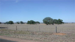
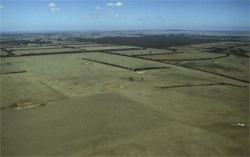 The gently undulating plains are mainly used for cropping and grazing (note the discoloured dam waters indicating dispersible soils) |
0.28% of CMA Region This unit is characterised by gently undulating plains that have primarily developed on Neogene and Quaternary sediments. With the few occurrences of this unit centred on Inverleigh in the Western Plains, south flowing streams such as the Leigh River have dissected this unit. This is a complex unit with many components grouped into undulating plains, upper and lower terraces and a variable terrain component. This is a drier part of the Corangamite catchment that supports the vegetation class Plains Grassy Woodland. The soils are dominantly (light) brown mottled texture contrast soils that are often sodic, with a large clay difference between the light surface soil and the heavy subsoil. Limited organic matter and structure in the surface will increase sheet erosion susceptibility, which will also be dependent on slope. Land use is generally grazing with some cropping. | 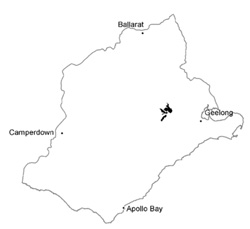 |
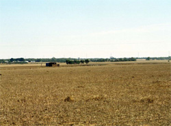 Stubble from cropping of the gentle plains |  |
 |  Remnant Eucalyptus camaldulensis and other eucalypt species on the cleared cropping country near Inverleigh |
Component | 1 | 2 | 3 | 4 | 5 | 6 | 7 | 8 |
Proportion of soil-landform unit | 13% | 2% | 37% | 6% | 18% | 5% | 3% | 16% |
| CLIMATE Rainfall (mm) | Annual: 550 | |||||||
| Temperature (oC) | Minimum 9, Maximum 19 | |||||||
| Precipitation less than potential evapotranspiration | October–April | |||||||
| GEOLOGY Age and lithology | Quaternary basalt | Neogene and older Quaternary unconsolidated clay and sand | Quaternary alluvium | |||||
| Geomorphology | ||||||||
| LANDUSE | Uncleared: Nature conservation Cleared: Beef cattle and sheep grazing; occasional cropping (cereal) | |||||||
| TOPOGRAPHY Landscape | Complex pattern of gently undulating plains | |||||||
| Elevation range (m) | 50–120 | |||||||
| Local relief (m) | 3 | |||||||
| Drainage pattern | Dendritic | |||||||
| Drainage density (km/km2) | 1.2 | |||||||
| Landform | Upper undulating plains | Upper terraces | Lower terrace and associated billabongs/swamps | Sandy ridges, scarps and hummocks | ||||
| Landform element | Long gentle upper slopes | Crests | Upper plain | Lower plain | Mid and lower slopes | Higher terraces | Lower terraces | Upper slope |
| Slope and range (%) | 2 (1–3) | 1 (0–3) | 3 (2–5) | 2 (1–5) | 2 (1–5) | 2 (0–3) | 1 (0–2) | 5 (2–15) |
| Slope shape | Straight | Convex | Straight | Straight | Straight | Straight | Straight | Convex |
| NATIVE VEGETATION Ecological Vegetation Class | Plains Grassy Woodland (7.2%) | |||||||
| Dominant species | E. ovata, E viminalis, E. rubida, E. obliqua | E. leucoxylon | E. leucoxylon, Acacia pycnantha, E. melliodora, Casurina stricta, E. viminalis | E. leucoxylon, Acacia spp. | E. leucoxylon | E. leucoxylon, E. camaldulensis | E. camaldulensis | E. camaldulensis |
| SOIL Parent material | In situ weathered basalt | Ferricrete and ferruginous sandy gravels | Unconsolidated clay, silt, sand and gravel | Unconsolidated clay, silt, sand and gravel | Unconsolidated older alluvium - clay, sand and gravel | Unconsolidated gravel, sand, silt and clay | Unconsolidated gravel, sand, silt and clay | Unconsolidated sediments |
| Description (Corangamite Soil Group) | Mottled brown, yellow or grey sodic texture contrast soil, coarse structure (14) | Gravelly red mottled brown, grey or yellow texture contrast soils, fine structure (15) | Mottled yellow and red texture contrast soils, both fine structured (13) | Mottled brown, grey or yellow sodic soils, coarse structure (14) | Mottled brown, grey or yellow texture contrast soils with red medium to coarse structured texture contrast soils (14) | Dark uniform loams (34) | Brown sand soils (34) | |
| Soil type sites | MM5109, SW63, MM5308 | |||||||
| Surface texture | Clay loam | Fine sandy loam | Fine sandy loam | Sandy loam | Fine sandy loam | Loamy sand and sandy loam | Loam to clay loam | Loamy sand |
| Permeability | Moderate to low | Moderate | Moderate | Low | Moderate | Moderate | High | High |
| Depth (m) | 1.5 | 0.3–0.9 | 1.0–2.0 | 2 | 0.8–1.5 | 0.5–1.0 | 0.2–0.8 | 0.7–1.5 |
| LAND CHARACTERISTICS, POTENTIAL AND LIMITATIONS | Hardsetting surfaces, slowly permeable subsoils and overland flow lead to periodic waterlogging and soil compaction. | Limited permeability, overland flow, minor sheet erosion on exposed soil. | Hardsetting surfaces, overland flow, minor sheet erosion. | Dispersible, overland flow, sub-surface flow, moderate gully erosion. | Limited permeability, overland flow, minor sheet erosion on exposed soil. | Limited permeability, overland flow, minor sheet erosion on exposed soil. | Low situation affected by flooding from river, overland flow, periodic waterlogging and siltation. | Nutrient holding capacity and leaching lead to nutrient decline. |
© State of Victoria (Agriculture Victoria) 1996 - .

This work, Victorian Resources Online, is licensed under a Creative Commons Attribution 4.0 licence. You are free to re-use the work under that licence, on the condition that you credit the State of Victoria (Agriculture Victoria) as author, indicate if changes were made and comply with the other licence terms.
The licence does not apply to ‘branding’ or some ‘images or photographs’ that may be owned by third parties. We ask you to seek prior approval to use images using the VRO feedback form. Access to higher quality images can also be provided on request.
This page was last updated on .