
Soil/Landform Unit 171
Landform Unit Description
Page top
 Long gentle slopes of the remnant ferruginised plateau |
1.10% of CMA region Between the ferruginised plateau of soillandform unit 79 and the basaltic plains, a long narrow plain extends from the Barwon River near Winchelsea to the middle reaches of Thompson Creek. Deeply weathered texture contrast soils are found on most of this unit, with occasional areas of aeolian sand. Remnants of woodlands and open forests are found along many reserves with the unusual occurrence of Eucalyptus pauciflora on many of the better drained and less fertile sites. Most areas have been cleared for agriculture and, despite the fairly low rainfall, dairy farming is common. Other uses include sheep and beef cattle grazing and cereal cropping. Soil salting is a problem in many areas and some minor gully erosion has also occurred. | 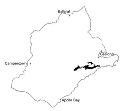 |
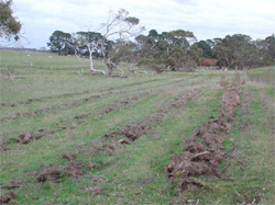 Drainage line of the Merrigig Creek with a planting of natives. Salinity was evident in this depression | 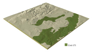 |
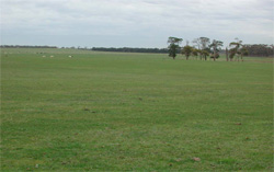
 | 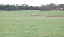 Undulating plains are mainly used for grazing by sheep and beef cattle |
Component | 1 | 2 | 3 | 4 | 5 |
Proportion of soil-landform unit | 35% | 20% | 10% | 15% | 10% |
| CLIMATE Rainfall (mm) | Annual: 600-650, lowest January (30), highest August (65) | ||||
| Temperature (oC) | Annual: 13, lowest July (9), highest February (19) | ||||
| Seasonal growth limitations | Temperature: less than 10oC (av.) June-July Precipitation: less than potential evapotranspiration October-mid April | ||||
| GEOLOGY Age and lithology | Neogene fluvio-marine sand and minor Recent clay, sand and gravel; Neogene marine marl and Paleogene fluvial sand | ||||
| Geomorphology | |||||
| LANDUSE | Cleared areas: Dairy and beef cattle grazing on mainly improved pastures; cereal cropping; some sand extraction | ||||
| TOPOGRAPHY Landscape | Gently undulating plain lying between basalt to the north and lateritic plateaux to the south | ||||
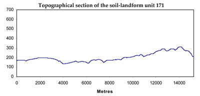
| Elevation range (m) | 40-130 | ||||
| Local relief (m) | 20 | ||||
| Drainage pattern | Dendritic | ||||
| Drainage density (km/km2) | 1.6 | ||||
| Landform | Gentle rises | Valley floors | |||
| Landform element | Crest and upper slope | Middle slope | Crest and slope | Lower slope | |
| Slope and range (%) | 3 (0-11) | 4 (1-7) | 5 (2-10) | 4 (0-7) | 1 (0-2) |
| Slope shape | Convex | Linear | Irregular | Convex | Concabe |
| NATIVE VEGETATION Structure | Open forest | Woodland | Low woodland | Woodland | Woodland |
| Dominant species | E. viminalis, E. ovata, E. pauciflora, Acacia melanoxylon | E. viminalis, E. ovata, Casuarina stricta, C. littoralis | E. viminalis, E. obliqua | E. ovata, E. viminalis, Casuarina stricta | E. camaldulensis, E. viminalis, Acacia melanoxylon |
| SOIL Parent material | Sandy clay | Sandy clay | Siliceous sand | Sandy clay | Sand, silt and clay |
| Description (Corangamite Soil Group) | Mottled brown, grey, yellow and red texture contrast soils (13) | Yellow-brown sodic texture contrast soils, coarse structure (14) | Grey sand soils (11) | Brown, grey or yellow sodic texture contrast soils (19) | Brown gradational soils (34) |
| Soil type sites | OTR492, OTR744 | OTR742 | OTR414, OTR416, OTR748 | ||
| Surface texture | Sandy loam | Fine sandy loam | Loamy sand | Sandy loam | Fine sandy loam |
| Permeability | Moderate | Low | Very high | Moderate | High |
| Depth (m) | >2 | >2 | >2 | >2 | >2 |
| LAND CHARACTERISTICS, POTENTIAL AND LIMITATIONS | Low inherent fertility, phosphorus fixation and leaching of permeable A horizons lead to nutrient decline. | Dispersible subsoils are prone to gully erosion and slumping of road batters. | Low inherent fertility and high permeability lead to nutrient decline. Weakly structured surfaces with low water holding capacity are prone to wind erosion. | Sodic subsoils with high seasonal watertables are prone to soil salting. Dispersible subsoils are prone to gully erosion. | Seasonal saline watertable development leads to soil salting. Rapid surface runoff from adjacent areas leads to scouring and gully erosion. Weakly structured surface soils in poorly drained areas are prone to compaction. |
© State of Victoria (Agriculture Victoria) 1996 - .

This work, Victorian Resources Online, is licensed under a Creative Commons Attribution 4.0 licence. You are free to re-use the work under that licence, on the condition that you credit the State of Victoria (Agriculture Victoria) as author, indicate if changes were made and comply with the other licence terms.
The licence does not apply to ‘branding’ or some ‘images or photographs’ that may be owned by third parties. We ask you to seek prior approval to use images using the VRO feedback form. Access to higher quality images can also be provided on request.
This page was last updated on .