
Soil/Landform Unit 165
Landform Unit Description
Page top
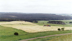
 View north-west over the former Heytesbury Soldier Settlement |
0.87% of CMA region Rolling hills of the Heytesbury region (often referred to as the Heytesbury Soldier Settlement) are formed from Miocene marine clay, marl and limestone. Included are the catchments of Scotts Creek and Cooriemungle Creek. Faulting and slumping of the landscape has led to occasional steep scarps, but most slopes are long, gentle and straight, separated by broad drainage lines. The soils on these Miocene sediments are typically brown, grey and black texture contrast soils, with heavier textured cracking clays lower in the landscape. Soils on these sediments are significantly more fertile than the soils formed on the Neogene sediments in adjacent units (Unit 86). Free lime is often preent at depth in the soil profile. Nearly all native vegetation has been cleared as part of the soldier settlement, apart from a significant remnant stand in the centre of the Heytesbury region. Dairy farming is the main land use. Subsoils are dispersible and gully erosion has occurred along some drainage lines. Landslip and slumping is a major engineering issue that escalates when soils are waterlogged. Drainage lines and lower slopes remain waterlogged for most of the year and are prone to soil compaction (pugging) by stock. |  |
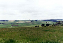 Gentle slopes of the highly dissected remnant plain in the Heytesbury region | 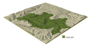 |
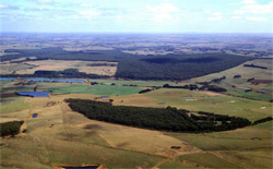
 |  Overlooking the remnant vegetation of the Heytesbury Soldier Settlement from Cowleys Creek |
Component | 1 | 2 | 3 | 4 | 5 |
Proportion of soil-landform unit | 4% | 65% | 20% | 8% | 3% |
| CLIMATE Rainfall (mm) | Annual: 900-1000, lowest January (40), highest August (120) | ||||
| Temperature (oC) | Annual: 14, lowest July (9), highest February (18) | ||||
| Seasonal growth limitations | Temperature: less than 10oC (av.) June-August Precipitation: less than potential evapotranspiration November-March | ||||
| GEOLOGY Age and lithology | Miocene marine marl. Recent clay, sand and gravel | ||||
| Geomorphology | |||||
| LANDUSE | Cleared areas: Dairy Minor uncleared areas: Nature conservation | ||||
| TOPOGRAPHY Landscape | Rolling hills | ||||
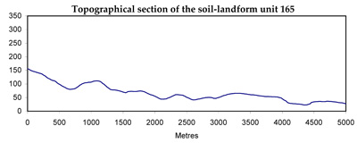
| Elevation range (m) | 20-170 | ||||
| Local relief (m) | 120 | ||||
| Drainage pattern | Dendritic | ||||
| Drainage density (km/km2) | 2.6 | ||||
| Landform | Hills | Valley floor | |||
| Landform element | Upper slope and crest | Mid slope | Lower slope | Low rises | Alluvial flats and fans |
| Slope and range (%) | 5 (0-12) | 5 (0-10) | 4 (1-7) | 1 (0-3) | 0 (0-1) |
| Slope shape | Convex | Concavo-Convex | Convex, linear | Convex | Linear |
| NATIVE VEGETATION Ecological Vegetation Class | Open forest | Woodland | Woodland | Closed scrub | Closed scrub |
| Dominant species | E. obliqua, E. ovata, E. aromaphloia | E. ovata, E. radiata | E. obliqua, E. ovata | Melaleuca squarrosa, Leptospermum lanigerum | Melaleuca squarrosa, Leptospermum lanigerum |
| SOIL Parent material | In situ marl | Colluvial marl | Colluvial/alluvial marl and sand | Colluvial/alluvial sand and marl | Alluvial sand and clay |
| Description (Corangamite Soil Group) | Brown, grey or yellow texture contrast soils (calcardous subsoils), coarse to fine structure (20) | Mottled brown, yellow and grey texture contrast soils, coarse to fine structure (20) | Mottled yellow and grey texture contrast soils (20) | Grey sandy soil with weakly cemented pan over mottled clay (22) | |
| Soil type sites | |||||
| Surface texture | Clay loam to clay | Sandy loam to clay | Sandy loam to clay | Sandy loam | Clay loam |
| Permeability | Very low | Very low | Very low | Low | Very low |
| Depth (m) | >2 | >2 | >2 | >2 | >2 |
| LAND CHARACTERISTICS, POTENTIAL AND LIMITATIONS | Heavy textured soils are very prone to pugging damage by cattle. Acidic surface. | All slopes are subject to periodic saturation are prone to severe waterlogging and pugging by cattle. Landslips and slumping of road batters are a major hazard. Soils respond well to subsurface drainage including mole drainage. | Soils are prone to severe waterlogging and pugging by cattle. Saline discharge occurs at toe slopes of landslides and in some drainage lines. Soils respond well to subsurface drainage including mole drainage. | Better draned surface soils of this element render it less prone to pugging by cattle. | Soils are prone to severe waterlogging and pugging by cattle. Soils respond well to subsurface drainage including mole drainage. |
© State of Victoria (Agriculture Victoria) 1996 - .

This work, Victorian Resources Online, is licensed under a Creative Commons Attribution 4.0 licence. You are free to re-use the work under that licence, on the condition that you credit the State of Victoria (Agriculture Victoria) as author, indicate if changes were made and comply with the other licence terms.
The licence does not apply to ‘branding’ or some ‘images or photographs’ that may be owned by third parties. We ask you to seek prior approval to use images using the VRO feedback form. Access to higher quality images can also be provided on request.
This page was last updated on .