
SW53
|
| SW53 | 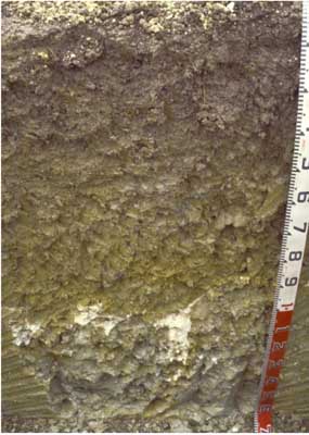 Vertic (and Sodic), Calcic Grey CHROMOSOL | |
| Cooriemungle (Boorook Road), Heytesbury district, south-west Victoria | |||
| Rolling hills | |||
| Neogene Gellibrand Marl: marine clays | |||
| Crest | |||
| 2% | |||
| South-west | |||
Horizon | Depth (cm) | Description | ||
A1 | 0–15 | Very dark greyish brown (10YR3/2 moist and 10YR5/3 dry); silty clay loam; weakly pedal structure; medium to fine (2–20 mm) polyhedral structure; pH 5.7; abrupt and smooth boundary to: | ||
B21g | 15–60/70 | Dark greyish brown (2.5Y4/2 moist) common (~15%), yellowish brown (10YR5/8 moist) mottles; medium clay; coarse (20–50 mm) polyhedral, parting to medium to fine (2–20 mm) polyhedral structure; pH 5.7; gradual and wavy boundary to: | ||
B22g | 60/70–105/115 | Light olive grey (2.5Y5/4 moist [50%] and grey 2.5Y5/1 moist [50%]); medium to heavy clay; coarse (50 mm) polyhedral or angular blocky , parting to medium to fine (5–20 mm) polyhedral structure; slickensides (>20 mm); pH 7.4; abrupt and irregular boundary to: | ||
B23kgss | 105/115–160+ | Light olive grey (5Y6/2 moist); common (~20%),yellowish brown (10YR5/8 moist) mottles; heavy clay; very coarse (100–300 mm) angular blocky, parting to coarse (20–50 mm) polyhedral or angular blocky, and medium to fine (2–20 mm) lenticular structure; soft white calcareous accumulations (up to 100 mm) at top of horizon; slickensides (>100 mm); pH 8.9. | ||
| Management considerations | ||||
| Generally used for dairying, these soils are prone to waterlogging and pugging. Although there is calcium carbonate at depth, surface horizons tend to be acidic and respond well to liming. On the steeper slopes this soil is highly prone to landslides. Subsurface drainage incorporating closely spaced mole drains works well in these soils. | ||||
Analytical data
Site SW53 | Sample depth | pH | EC | NaCl | Ex Ca | Ex Mg | Ex K | Ex Na | Ex Al | Ex acidity | FC (-10kPa) | PWP (-150kPa) | KS | FS | Z | C | |
Horizon | cm | H2O | CaCl2 | dS/m | % | cmolc/kg | cmolc/kg | cmolc/kg | cmolc/kg | mg/kg | cmolc/kg | % | % | % | % | % | % |
A1 | 0-10 | 5.7 | 4.9 | 0.11 | N/R | 8.8 | 3.8 | 0.63 | 0.48 | 13 | 15 | 38.6 | 17.4 | 7.4 | 25.4 | 30 | 27 |
B21 | 15-60 | 5.7 | 4.5 | 0.1 | N/R | 8.5 | 9.4 | 0.51 | 1.2 | 240 | 13 | 44.5 | 24.1 | 0.5 | 17.4 | 19 | 58.5 |
B22 | 70-105 | 7.4 | 6.2 | 0.16 | N/R | 16 | 13 | 0.43 | 3.2 | N/R | N/R | 53 | 26.3 | 0.7 | 12.1 | 17.5 | 65 |
B23 | 105-160 | 8.9 | 8.9 | 0.77 | 0.09 | 16 | 14 | 2.9 | 5.8 | N/R | N/R | N/R | N/R | N/R | N/R | N/R | N/R |
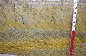 | ||
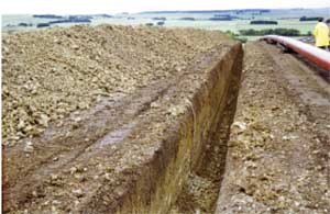
Slip plane features evident in trench below SW53: view downslope (left) profile view (centre), view upslope (right) | ||
© State of Victoria (Agriculture Victoria) 1996 - .

This work, Victorian Resources Online, is licensed under a Creative Commons Attribution 4.0 licence. You are free to re-use the work under that licence, on the condition that you credit the State of Victoria (Agriculture Victoria) as author, indicate if changes were made and comply with the other licence terms.
The licence does not apply to ‘branding’ or some ‘images or photographs’ that may be owned by third parties. We ask you to seek prior approval to use images using the VRO feedback form. Access to higher quality images can also be provided on request.
This page was last updated on .