
SW59
|
| SW59 | 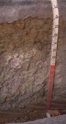 Sesquic, Semiaquic PODOSOL | |
| South of Simpson: Cooriemungle Road and Princetown Road | |||
| Dissected plain | |||
| Veneer of Neogene Hanson Plain Sand overlying Neogene Gellibrand Marl | |||
| Upper slope / crest | |||
| 2% | |||
| South-west | |||
Horizon | Depth (cm) | Description | ||
A1 | 0–15 | Black (2.5Y2.5/1); sandy loam; pH 5.6; smooth boundary to: | ||
A2 | 15–30 | Intermittent horizon; conspicuously bleached; clear and wavy boundary to: | ||
B21s | 15/30–60 | Mottled yellowish brown (10YR5/8 moist) and very dark greyish brown (10YR3/2 moist); sandy clay loam; weak very fine polyhedral structure; weak to firm consistence (weakly cemented, weak ‘coffee rock’); pH 5.3; gradual and wavy boundary to: | ||
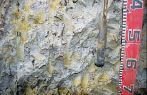
B22g | 60–90 | Light olive brown (2.5Y5/4 moist) with prominent yellowish brown (10YR7/8 moist) to yellow (10YR5/8 moist) mottles; sandy clay; very coarse (50–100 mm) polyhedral, parting to coarse (20–50 mm) blocky structure; sand coatings (whitish) on the larger ped faces; pH 5.5; clear smooth boundary to: | ||
B23gss | 90+ | Light greenish grey (5GY7/1 moist); heavy clay; brownish yellow (10YR6/8 moist) mottles; very coarse (50–100 mm) polyhedral, parting to coarse (20–50 mm) blocky structure; slickensides (>50 mm) present; pH 6.3. | ||
| Management considerations | ||||
| The lighter textured topsoil and landscape position renders the soil surface less prone to pugging damage than many of the soils in the district. The weakly cemented subsoil (B21s) is acid, has low levels of nutrients and poor nutrient holding capacity. Regular applications of balanced fertilizer as well as lime are needed to get good pasture production on these soils. The severe waterlogging and saturation of the deeper heavy clay subsoil is a permanent limitation to root growth as well as contributing to the landslide hazard associated with the slopes below this site. See also SW53 for soil in equivalent landscape position but without Hanson Plain Sand topsoil. | ||||
Analytical data
Site SW59 | Sample depth | pH | EC | NaCl | Ex Ca | Ex Mg | Ex K | Ex Na | Ex Al | Ex acidity | FC (-10kPa) | PWP (-150kPa) | KS | FS | Z | C | |
Horizon | cm | H2O | CaCl2 | dS/m | % | cmolc/kg | cmolc/kg | cmolc/kg | cmolc/kg | mg/kg | cmolc/kg | % | % | % | % | % | % |
A | 0–30 | 5.6 | 5 | 0.16 | N/R | 5.8 | 0.87 | 0.26 | 0.33 | <10 | 12 | 19.9 | 9.1 | 24.4 | 49.2 | 11 | 8.5 |
| Sporadic A2 not sampled | |||||||||||||||||
B21 | 30–60 | 5.3 | 4.5 | 0.08 | N/R | 0.83 | 1 | 0.12 | 0.27 | 150 | 11 | 19.6 | 11.3 | 18.4 | 47.6 | 2 | 25 |
B22 | 60–90 | 5.5 | 4.6 | 0.08 | N/R | 1.2 | 2.8 | 0.14 | 0.41 | 61 | 5.7 | 22.4 | 12.4 | 18 | 44.2 | 3.5 | 33 |
B23 | 90+ | 6.3 | 5.2 | 0.14 | N/R | N/R | N/R | N/R | N/R | N/R | N/R | N/R | N/R | N/R | N/R | N/R | N/R |
© State of Victoria (Agriculture Victoria) 1996 - .

This work, Victorian Resources Online, is licensed under a Creative Commons Attribution 4.0 licence. You are free to re-use the work under that licence, on the condition that you credit the State of Victoria (Agriculture Victoria) as author, indicate if changes were made and comply with the other licence terms.
The licence does not apply to ‘branding’ or some ‘images or photographs’ that may be owned by third parties. We ask you to seek prior approval to use images using the VRO feedback form. Access to higher quality images can also be provided on request.
This page was last updated on .