
Soil/Landform Unit 125
Landform Unit Description
Page top
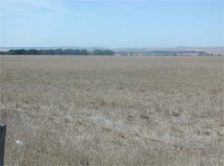
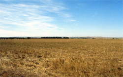 Cropping and grazing are the major land uses of these plains west of Inverleigh |
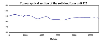
0.43% of CMA region This unit of gently undulating plains formed on the Quaternary basalt of the Western Plains is characterised by long gentle slopes with minor swamps, drainage depressions and lunettes. Comprising a single entity between Wingeel and Inverleigh, the gentle plain is bound by other basaltic plains to the west and north, and terraces and dissected valleys to the east and south-east. The soils are mottled brown and yellow sodic texture contrast soils (Sodosol to the east and southeast) with occasional stone content. Remnant vegetation includes Plains Grassland/Plains Grassy Woodland Mosaic. This area is relatively dry for the catchment and land use is dominantly grazing for sheep production and cereal cropping. The strongly sodic soils generally have susceptibilities to structure decline, compaction and local waterlogging. |  |
 Most of the gently undulating plains have been clared previously as part of the large pastoral runs of the south-west Victoria | 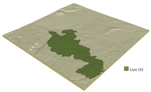 |
 |
Component | 1 | 2 | 3 | 4 |
Proportion of soil-landform unit | 82% | 10% | 5% | 3% |
| CLIMATE Rainfall (mm) | Annual: 570 | |||
| Temperature (oC) | Minimum 9, Maximum 19 | |||
| Precipitation less than potential evapotranspiration | October-April | |||
| GEOLOGY Age and lithology | Quaternary basalt and fluvial clay, sand and gravel | |||
| Geomorphology | ||||
| LANDUSE | Uncleared areas: Nature conservation Cleared areas: Sheep and beef cattle grazing; cropping (cereal) | |||
| TOPOGRAPHY Landscape | Gently undulating plains | |||
| Elevation range (m) | 62-133 | |||
| Local relief (m) | 30 | |||
| Drainage pattern | Dendritic | |||
| Drainage density (km/km2) | 0.7 | |||
| Landform | Plains | |||
| Landform element | Plain | Drainage line and depression | Swamps | Lunette |
| Slope and range (%) | 1 (0-3) | 1 (0-2) | 0 | 3 (2-8) |
| Slope shape | Straight | Concave | Straight | Convex |
| NATIVE VEGETATION Ecological Vegetation Class | Plains Grassland / Plains Grassy Woodland Mosaic (0.7%) | |||
| SOIL Parent material | In situ basalt and colluvium | Basaltic colluvium and alluvium | Clay, silt and sand | Clay, silt and sand |
| Description (Corangamite Soil Group) | Grey self-mulching and cracking clays (9) | |||
| Soil type sites | ||||
| Surface texture | Fine sandy clay loam | Fine sandy clay loam | Light medium clay | Light clay |
| Permeability | Low | Very low | Very low | Moderate to high |
| Depth (m) | <2 | >2 | >2 | >2 |
| LAND CHARACTERISTICS, POTENTIAL AND LIMITATIONS | Textue contrast, mottled. Poor drainage. Low infiltration if trafficked and susceptible to compaction. Moderate to high nutrient holding capacity and strongly sodic subsoil. | Texture contrast, mottled. Poor drainage. Low infiltration if trafficked and susceptible to compaction. Moderate to high nutrient holding capacity and strongly sodic subsoil. | Heavy texture (clay) with depth. Very poor drainage. Low infiltration if trafficked and susceptible to compaction once moist. May have friable surface when dry or slightly moist. High nutrient holding capacity. | Heavy texture (clay) with depth. Strongly structured with calcareous material at depth, moderately well drained. May have friable surface when dry or slightly moist. High nutrient holding capacity. |
© State of Victoria (Agriculture Victoria) 1996 - .

This work, Victorian Resources Online, is licensed under a Creative Commons Attribution 4.0 licence. You are free to re-use the work under that licence, on the condition that you credit the State of Victoria (Agriculture Victoria) as author, indicate if changes were made and comply with the other licence terms.
The licence does not apply to ‘branding’ or some ‘images or photographs’ that may be owned by third parties. We ask you to seek prior approval to use images using the VRO feedback form. Access to higher quality images can also be provided on request.
This page was last updated on .