
Soil/Landform Unit 117
Landform Unit Description
Page top
 Broad basaltic plains with broadly defined drainage flats and depressions |
4.64% of CMA region This unit of undulating basaltic plains has poorly developed drainage and regolith and lies within the volcanic Western Plains. This very large unit on a north-west–south-east axis extends from Wallindoc in the north, through Cressy and south to Winchelsea. Unit components include stony undulating plain/rises, plains and minor depressions. The remnant native vegetation class is Plains Grassland/Plains Grassy Woodland Mosaic. The soils are alkaline (strongly sodic) mottled black texture contrast soils (Sodosols), with some gradational soils (Dermosols) on the stonier (and shallower) rises. Rainfall decreases from north to south with more broadacre grazing and cropping further south. This unit is susceptible to waterlogging and (compaction where the lighter upper soil is shallow) and some nutrient decline. Some areas are also susceptible to sheet and rill erosion and structure decline with the strongly sodic subsoils and surface soils. | 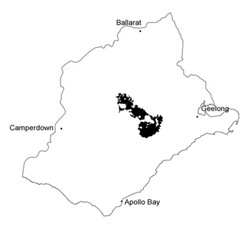 |
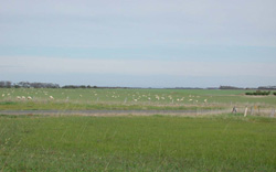
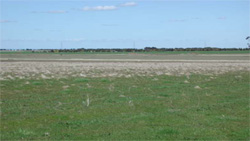
 Fodder crop on gently undulting plains near Wilgul | 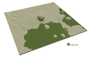 |
 |  Cleared plains near Wilgul. The little basalt rock that occurs on these plains hs been cleared into heaps |
Component | 1 | 2 | 3 |
Proportion of soil-landform unit | 55% | 35% | 10% |
| CLIMATE Rainfall (mm) | Annual: 600 | ||
| Temperature (oC) | Minimum 9, Maximum 19 | ||
| Precipitation less than potential evapotranspiration | October-March | ||
| GEOLOGY Age and lithology | |||
| Geomorphology | |||
| LANDUSE | Uncleared areas: Nature conservation Cleared areas: Sheep and beef cattle grazing; cropping (cereal); softwood plantations | ||
| TOPOGRAPHY Landscape | Gently undulating basalt plains | ||
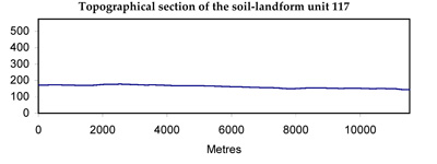
| Elevation range (m) | 70-223 | ||
| Local relief (m) | 50 | ||
| Drainage pattern | Centripetal | ||
| Drainage density (km/km2) | 0.5 | ||
| Landform | Plain | ||
| Landform element | Undulating stony rise | Plains | Depressions |
| Slope and range (%) | 2 (1-8) | 1 (0-3) | 2 (1-3) |
| Slope shape | Convex | Straight | Concave |
| NATIVE VEGETATION Ecological Vegetation Class | Plains Grassland/Plains Grassy Woodland Mosaic (0.2%) | ||
| SOIL Parent material | Basalt | Basalt and colluvium | Basalt, colluvium and alluvium |
| Description (Corangamite Soil Group) | Alkaline mottled black texture contrast soils (35) | Grey and black cracking clays (39) | |
| Soil type sites | |||
| Surface texture | Fine sandy clay loam | Fine sandy clay loam | Light clay |
| Permeability | Moderate to low | Low | Very low |
| Depth (m) | <2 | <2 | >2 |
| LAND CHARACTERISTICS, POTENTIAL AND LIMITATIONS | Texture contrast soil, moderate water holding capacity and nutrient holding capacity in variable depth surfae and subsurface soils (gilgai), higher in deep expansive clay subsoil. High (loams) to low permeability. Sodic, often strongly sodic subsoil. Some stone on broad crests/rises. Moderate to slow site drainage. | Texture contrast soil; moderate water holding capacity and nutrient holding capacity in variable depth surface and subsurface soils (gilgai), higher in deep expansive clay subsoil. Low permeability and sodic (often strongly) subsoil. Slow site drainage. | Uniform expansive clay soil, high to very high water holding capacity and nutrient holding capacity. Cracking soil, black soil may have self-mulching surfaces. Low permeability once moist; sodic (often strongly) subsoil. Slow to very slow site drainage. |
© State of Victoria (Agriculture Victoria) 1996 - .

This work, Victorian Resources Online, is licensed under a Creative Commons Attribution 4.0 licence. You are free to re-use the work under that licence, on the condition that you credit the State of Victoria (Agriculture Victoria) as author, indicate if changes were made and comply with the other licence terms.
The licence does not apply to ‘branding’ or some ‘images or photographs’ that may be owned by third parties. We ask you to seek prior approval to use images using the VRO feedback form. Access to higher quality images can also be provided on request.
This page was last updated on .