
Soil/Landform Unit 116
Landform Unit Description
Page top
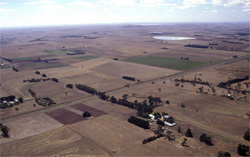 Soils of the gentle low hills between Colac and Winchelsea are mainly used for grazing and cropping |
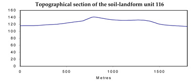
0.03% of CMA region The undulating low hills east of Colac are derived from basalt that has little regolith development. As part of the Western Plains, these low hills are visible from the Princes Highway when heading to Winchelsea from Colac. The local relief of these hills is nearly 35 m. The low hills have little remnant vegetation (less than 1%) with the major vegetation class being Plains Grassy Woodland. The hills have slopes and footslopes that have been used for cereal production and grazing (beef cattle). The basaltic rock supports mottled yellow and black texture contrast soils. Surface stones are mainly confined to the crest and upper slopes, though basalt floaters can make cultivation difficult on steeper slopes. Nutrient decline is a minor degradation issue of these low hills. |  |
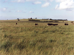 Slopes of the low hills are long and gentle with no remnant vegetation remaining |  |
 |
Component | 1 | 2 | 3 |
Proportion of soil-landform unit | 10% | 65% | 25% |
| CLIMATE Rainfall (mm) | Annual: 720 | ||
| Temperature (oC) | Minimum 9, Maximum 19 | ||
| Precipitation less than potential evapotranspiration | October-March | ||
| GEOLOGY Age and lithology | Quaternary basalt | ||
| Geomorphology | |||
| LANDUSE | Uncleared areas: Nature conservation Cleared areas: Beef cattle grazing; cropping (cereal) | ||
| TOPOGRAPHY Landscape | Undulating low basalt hills | ||
| Elevation range (m) | 110-160 | ||
| Local relief (m) | 32 | ||
| Drainage pattern | Dendritic | ||
| Drainage density (km/km2) | 0.3 | ||
| Landform | Low gentle hills | ||
| Landform element | Crest | Hillslope | Footslope |
| Slope and range (%) | 4 (1-7) | 7 (3-10) | 5 (2-9) |
| Slope shape | Convex | Convex | Concave |
| NATIVE VEGETATION Ecological Vegetation Class | Plains Grassy Woodland (0.8%) | ||
| SOIL Parent material | Basalt | Basalt | Basalt |
| Description (Corangamite Soil Group) | Alkaline mottled black and mottled yellow or brown texture contrast soils (35) | Alkaline mottled black and mottled brown, grey or yellow texture contrast soils (35) | |
| Soil type sites | |||
| Surface texture | Fine sandy clay loam | Fine sandy clay loam | Fine sandy clay loam |
| Permeability | Low | Low | Very low |
| Depth (m) | <1 | 1-2 | >2 |
| LAND CHARACTERISTICS, POTENTIAL AND LIMITATIONS | Texture contrast, moderate to high water holding capacity and nutrient holding capacity depending on depth and stoniness. Strongly sodic soils with coarse structure, hardsetting. Minor non-sodic soils with medium structure. Moderately rapid site drainage. Some susceptibility to sheet and rill erosion. | Texture contrast, moderate to high water holding capacity and nutrient holding capacity depening on depth and stoniness. Strongly sodic soils with coarse structure, hardsetting. Moderately rapid site drainage. Some susceptibility to sheet and rill erosion. | Texture contrast, moderate to high water holding capacity and nutrient holding capacity depening on depth and stoniness. Strongly sodic soils with coarse structure, hardsetting. Moderately rapid site drainage. Some susceptibility to sheet and rill erosion. |
© State of Victoria (Agriculture Victoria) 1996 - .

This work, Victorian Resources Online, is licensed under a Creative Commons Attribution 4.0 licence. You are free to re-use the work under that licence, on the condition that you credit the State of Victoria (Agriculture Victoria) as author, indicate if changes were made and comply with the other licence terms.
The licence does not apply to ‘branding’ or some ‘images or photographs’ that may be owned by third parties. We ask you to seek prior approval to use images using the VRO feedback form. Access to higher quality images can also be provided on request.
This page was last updated on .