
Soil/Landform Unit 115
Landform Unit Description
Page top
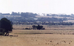 The undulating low basalt hill of Mount Duneed has stony upper slopes, with black self-mulching soils supporting cropping on the lower slopes |
0.03% of CMA region The undulating low basalt hills south-east of Skipton, and Mount Duneed are part of sequence of volcanic landforms within the dissected plains of the Western Plains. These low hills are characterised by steep middle and upper slopes with more gentle lower slopes. The low hills support the vegetation class Plains Grassland. The upper slopes and crests have minor occurrences of friable red gradational soils where there are many surface stones. The mid and upper slopes provide red texture contrast soils with hard or friable surfaces while the lower slopes have black self-mulching soils. Agricultural land use is composed of beef cattle and sheep grazing, and cropping. Erosion hazards are minimal. Areas with shallow stony gradational soils are susceptible to leaching of nutrients, and compaction is a problem on the lower slopes and depressions. Waterlogging on the lower slopes may be due to the low relief and sometimes hardsetting surfaces of these soils. |  |
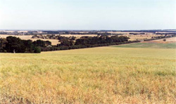
 Lower slopes leading to roundabout on the Surfcoast Highway at Mount Duneed | 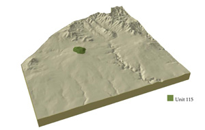 |
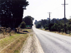
 |  Western slopes of Mount Duneed |
Component | 1 | 2 | 3 |
Proportion of soil-landform unit | 25% | 30% | 45% |
| CLIMATE Rainfall (mm) | Annual: 640 | ||
| Temperature (oC) | Minimum 8, Maximum 19 | ||
| Precipitation less than potential evapotranspiration | October-March | ||
| GEOLOGY Age and lithology | |||
| Geomorphology | |||
| LANDUSE | Uncleared areas: Nature conservation Cleared areas: Sheep and beef cattle grazing; cropping (cereal) | ||
| TOPOGRAPHY Landscape | Low basalt hills | ||
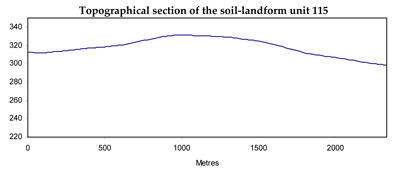
| Elevation range (m) | 44-337 | ||
| Local relief (m) | 70 | ||
| Drainage pattern | Dendritic | ||
| Drainage density (km/km2) | 0.2 | ||
| Landform | Low hill | ||
| Landform element | Crest, gentle upper slopes | Steeper mid and upper slopes | Lower slopes |
| Slope and range (%) | 3 (1-7) | 6 (3-15) | 3 (1-8) |
| Slope shape | Convex | Concavo-Convex | Concave |
| NATIVE VEGETATION Ecological Vegetation Class | Plains Grassland (0.8%) | ||
| SOIL Parent material | In situ weathered basalt | In situ weathered basalt | In situ weathered basalt |
| Description (Corangamite Soil Group) | Shallow black self-mulching soils (39) | ||
| Soil type sites | |||
| Surface texture | Loams | Loams | Clays |
| Permeability | High | High | Very low |
| Depth (m) | <0.7 | <1 | <1 |
| LAND CHARACTERISTICS, POTENTIAL AND LIMITATIONS | Texture contrast soils tend to have low water holding capacity, moderate nutrient holding capacity in upper soil, high in subsoil. Gradational soils, low to moderate water holding capacity, moderate to high nutrient holding capacity. Shallow to moderately deep, friable, often stony. Moderately rapid site drainage. Slight susceptibility to sheet erosion. | Texture contrast soils tend to have low water holding capacity, moderate nutrient holding capacity in upper soil, high in subsoil. Gradational soils, low to moderate water holding capacity, moderate to high nutrient holding capacity. Shallow to moderately deep, friable, often stony. Moderately rapid site drainage. Slight susceptibility to sheet erosion. | Uniform expansive clay soils, high water holding capacity, very high nutrient holding capacity. Shallow to moderate deep, friable and self-mulching, often stony. Moderate site drainage. Slight suceptibility to sheet and rill erosion. |
© State of Victoria (Agriculture Victoria) 1996 - .

This work, Victorian Resources Online, is licensed under a Creative Commons Attribution 4.0 licence. You are free to re-use the work under that licence, on the condition that you credit the State of Victoria (Agriculture Victoria) as author, indicate if changes were made and comply with the other licence terms.
The licence does not apply to ‘branding’ or some ‘images or photographs’ that may be owned by third parties. We ask you to seek prior approval to use images using the VRO feedback form. Access to higher quality images can also be provided on request.
This page was last updated on .