
Kandosols
Kandosols (Australian Soil Classification) lack strong texture contrast between the surface (A) horizons and subsoil (B) horizons. They are also characterised by having massive (i.e. structureless) or only very weakly structured subsoils that are often 'earthy' in appearance. Some part of the weakly developed B horizon must have a clay content of more than 15%. Kandosols are usually well drained, permeable soils and often have low fertility.
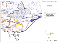 Kandosols in the West Gippsland Region |
This overview map of Ferrosols in the West Gippsland region has been developed from more detailed regional soil/landform mapping (Sargeant and Imhof, In press). It shows areas where Ferrosols are most likely to occur within the region and should only be used as a general indication of their distribution. Note that other soil types may also occur within these mapped areas. Also, some areas (e.g. forested areas in the north of the region) have been largely unsurveyed and the distribution of soil types is not well known. |
Kandosols are not common in West Gippsland. These strongly leached soils are most likely to occur on Tertiary hills and rises to the south-west and south-east of Morwell. These represent relatively old landscapes.
© State of Victoria (Agriculture Victoria) 1996 - 2025.

This work, Victorian Resources Online, is licensed under a Creative Commons Attribution 4.0 licence. You are free to re-use the work under that licence, on the condition that you credit the State of Victoria (Agriculture Victoria) as author, indicate if changes were made and comply with the other licence terms.
The licence does not apply to ‘branding’ or some ‘images or photographs’ that may be owned by third parties. We ask you to seek prior approval to use images using the VRO feedback form. Access to higher quality images can also be provided on request.
This page was last updated on 25/01/2019.