
Ferrosols
Ferrosols (Australian Soil Classification) are soils lacking strong texture contrast between surface (A) horizons and the upper subsoil (B21) horizon. These soils are also characterised by relatively high levels of free iron oxide (i.e. free iron oxide content greater than 5%). Several Suborders can be separated, based on the colour of the major part of the subsoil (e.g. into Red, Brown, Yellow, Grey and Black groups). Mainly Red Ferrosols have been described in Gippsland.
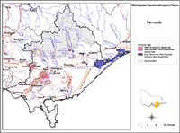 Ferrosols in the West Gippsland |
This overview map of Ferrosols in the West Gippsland region has been developed from more detailed regional soil/landform mapping (Sargeant and Imhof, In press). It shows areas where Ferrosols are most likely to occur within the region and should only be used as a general indication of their distribution. Note that other soil types may also occur within these mapped areas. Also, some areas (e.g. forested areas in the north of the region) have been largely unsurveyed and the distribution of soil types is not well known. |
 Red Ferrosol near Ellinbank. |
Ferrosols are common in the central parts of the West Gippsland region. They are deep red friable soils that have formed on Tertiary basalts (commonly called Older Volcanics) and are associated with rolling hills in the Warragul and Thorpdale regions where dairying and horticulture (mainly potato cropping) occur. These Red Ferrosols are generally strongly acidic throughout, lack strong texture contrast and are high in free iron oxide. Minor occurrences of stony Brown and Red Ferrosols occur on rolling to steep basalt hills west of Lake Glenmaggie. |
© State of Victoria (Agriculture Victoria) 1996 - .

This work, Victorian Resources Online, is licensed under a Creative Commons Attribution 4.0 licence. You are free to re-use the work under that licence, on the condition that you credit the State of Victoria (Agriculture Victoria) as author, indicate if changes were made and comply with the other licence terms.
The licence does not apply to ‘branding’ or some ‘images or photographs’ that may be owned by third parties. We ask you to seek prior approval to use images using the VRO feedback form. Access to higher quality images can also be provided on request.
This page was last updated on .