CFTT9
| Location: Maryvale. | Australian Soil Classification: Bleached-Sodic (& Vertic), Magnesic, Grey KUROSOL. |
| Great Soil Group: grey soloth. | Geology: Late Tertiary sediments. |
| General Landscape Description: Simple 2% slope to north west. | Mapping Unit: Maryvale. |
| Site Description: Eucalypt plantation. | |
Soil Profile Morphology:
Surface Soil
| A1 | 0 – 20 cm | Very dark greyish brown (10YR3/2); fine sandy loam; weak medium polyhedral structure; very weak consistence moderately moist; pH 5.1; clear and sharp transition to: | 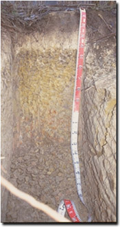 Site CFTT 9 Soil Profile |
| A2 | 20 – 40 cm | Brown (10YR5/3), conspicuously bleached with a few medium distinct yellowish brown (10YR5/6) mottles; fine sandy loam; massive; very weak consistence dry; pH 5.0; abrupt and smooth transition to: | |
| Subsoil | |||
| B21 | 40 – 90 cm | Light brownish grey (2.5Y6/2) with many coarse prominent yellowish brown (10YR5/6) mottles; medium clay; strong coarse prismatic, parting to moderate medium prismatic structure; strong consistence moist; pH 5.3; diffuse and smooth transition to: | |
| B22 | 90 – 125 cm | Light grey (10YR7/1) with many prominent red (2.5YR4/6) mottles (and decreasing yellowish brown (10YR5/6) mottles); medium clay; moderate to coarse prismatic, parting to weak fine prismatic structure; strong consistence moist; pH 5.0; diffuse and smooth transition to: | |
| B23 | 125 – 200 cm | Light grey (10YR7/1) with many, very coarse sized, prominent, red (2.5YR4/6) mottles; medium clay; moderate prismatic, parting to coarse lenticular structure, slickensides evident on ped faces; strong consistence moist. | |
Key Profile Features:
- Strong texture contrast between surface (A) horizons and subsoil (B21) horizon.
- Conspicuously bleached subsurface (A2) horizon.
Soil Profile Characteristics:
Horizon | pH | Salinity Rating | ||
Surface (A1 horizon) | Strongly acid | Very low | Non-sodic | None |
Subsoil (B21 horizon) | Strongly acid | Low | Sodic | Slight 1 |
Deeper subsoil (at 1 m) | Very strongly acid | Medium | Sodic | None |
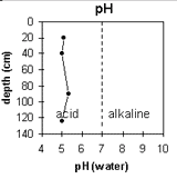 | The soil profile is strongly to very strongly acid throughout. | 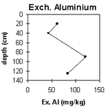 | The level of exchangeable aluminium is highest in the upper subsoil. |
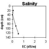 | The level of soluble salts increases in the deeper profile. | 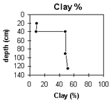 | There is a significant increase in clay content at the A/B horizon interface |
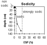 | The subsoil becomes increasingly sodic with depth. |
Horizon | Horizon Depth (cm) | pH (water) | pH (CaCl2) | EC 1:5 | NaC % | Exchangeable Cations | Exchangable Aluminium mg/kg | Exchangable Acidity meq/100g | Field Capacity pF 2.5 | Wilting Point
pF 4.2 | Coarse Sand (0.2 - 2 mm) | Fine Sand (0.02 -0.2 mm) | Silt (0.002 -0.02 mm) | Clay (<0.002 mm) | |||
Ca | Mg | K | Na | ||||||||||||||
meq/100g | |||||||||||||||||
A1 | 0-20 | 5.1 | 4.3 | 0.06 | 1.2 | 0.68 | 0.16 | 0.15 | 62 | 9.4 | 23 | 5 | 14 | 52 | 19 | 10 | |
A2 | 20-40 | 5 | 4.3 | <0.05 | 0.24 | 0.28 | 0.09 | 0.09 | 43 | 4 | 15 | 3 | 17 | 54 | 19 | 9 | |
B21 | 40-90 | 5.3 | 4.3 | 0.3 | 0.05 | 0.2 | 6.4 | <0.1 | 1 | 120 | 8.8 | 32 | 18 | 9 | 24 | 15 | 48 |
B22 | 90-125 | 5 | 4.4 | 0.53 | 0.11 | 0.2 | 6.5 | <0.1 | 2.1 | 84 | 7.8 | 36 | 19 | 5 | 20 | 21 | 52 |
Management Considerations:
- No impeding layers evident to 2 metres depth - although the subsoil clay is tough. It should be noted that this type of soil profile occupies two-thirds of the site, with a heavier profile (see below) occupying the lower part.
- The dense and coarsely structured subsoil is sodic and slightly dispersive (but dispersion may be suppressed by the exchangeable aluminium). Root and water movement in the subsoil will be restricted as a result. After heavy rains, water is likely to build up on top of the slowly permeable subsoil and waterlogging may occur (as is indicated by the conspicuously bleached A2 horizon).
- The subsoil has a very low exchangeable calcium:magnesium ratio (0.1). Calcium deficiencies may occur as a result.
- The soil profile is strongly to very strongly acid throughout. Availability of some trace elements (e.g. copper, molybdenum) may be low as a result. Aluminium toxicity can be a problem in strongly acid soils. The levels measured here are moderate and may restrict the growth of highly aluminium sensitive species.
- The moderate level of soluble salts in the deeper subsoil (i.e. from 1 metre depth) may restrict the growth of deeper-rooted salt sensitive species.


