
SG6
Location: Korumburra South
Australian Soil Classification: Acidic, Mesotrophic, Grey DERMOSOL.
Great Soil Group: brown podzolic
Northcote Factual Key: Gn 4.51
Soil Map Unit: Strzelecki
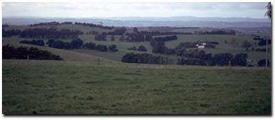
General Landscape Description: Upper slope of hillslope (15% slope).
Site Description: Roadside cutting near Korumburra South.
Geology: Cretaceous sediments.
Native Vegetation: Includes Manna Gum (Eucalyptus viminalis), Blue Gum (E. globulus), Blackwood (Acacia melanoxylon) and Swamp Paperbark (M. ericifolia).
 SG6 Landscape |
Soil Profile Morphology:
| Surface Soil | 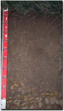 SG6 Profile | ||
| A1 | 0-35 cm | Dark brown (10YR4/3); light fine sandy clay loam; firm surface condition; moderate fine polyhedral structure; weak consistence moist; pH 5.7; gradual change to: | |
| Subsoil | |||
| B1 | 35-55 cm | Brown (10YR5/3); light fine sandy clay loam; weak medium blocky, parting to moderate fine blocky structure; weak consistence moist; pH 5.4; clear change to: | |
| B2 | 55-85 cm | Greyish brown (10YR5/2); fine sandy clay loam; moderate medium subangular blocky structure; weak consistence moist; pH 5.6; sharp and wavy change to: | |
| C | 85+ cm | Weathering sediments. | |
Key Profile Features:
- Lack of significant texture change throughout the profile.
Soil Profile Characteristics:
pH | Salinity Rating | Sodicity | |
Surface (A1 horizon) | Moderately Acid | Very Low | Non-Sodic |
Subsoil (B21 horizon) | Strongly Acid | Very Low | Non-Sodic |
Deeper subsoil (at 75-100 cm) | Moderately Acid | Very Low | Non-Sodic |
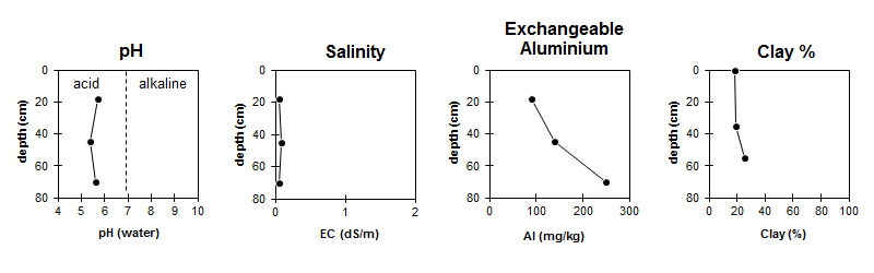
The pH ranges between moderate to strongly acid throughout the soil profile. | The salinity rating is very low throughout the profile. | The exchangeable aluminium level increases with depth. | The clay % increases gradually with depth. |
Horizon | Horizon Depth (cm) | pH (water) | pH (CaCl2) | EC ds/m | Organic Carbon % | Nitrogen % | Exchangeable Cations | Exchangeable Aluminium mg/kg | Exchangeable Acidity meg/100g | Field Capacity pF 2.5 | Wilting Point pF 4.2 | Coarse Sand (0.02 -0.2mm) | Fine Sand (0.02 -0.2mm) | Silt (0.02 -0.2mm) | Clay (<0.002mm) | |||
Ca | Mg | K | Na | |||||||||||||||
meg/100g | ||||||||||||||||||
A1 | 0-35 | 5.7 | 4.5 | 0.06 | 2.0 | 0.17 | 1.9 | 1.5 | 0.1 | 0.2 | 90 | 11.5 | 27.3 | 8.1 | 7.8 | 40.0 | 29.0 | 18.0 |
B1 | 35-55 | 5.4 | 4.3 | 0.08 | 1.0 | 1.0 | 0.1 | 0.2 | 140 | 10.0 | 24.9 | 7.2 | 7.8 | 40.0 | 31.5 | 19.0 | ||
B21 | 55-85 | 5.6 | 4.1 | 0.05 | 0.8 | 1.5 | 0.1 | 0.2 | 250 | 10.3 | 24.3 | 9.6 | 7.5 | 39.6 | 26.5 | 25.0 | ||
Management Considerations:
Whole Profile
- Plant Available Water Capacity (PAWC) is considered to be low (estimated at approximately 70 mm). This is based on available laboratory data and assumes an effective rooting depth of 85 cm. Rooting depth will be limited by the sandstone base.
- The soil profile will be relatively well drained.
- The exchangeable aluminium level is only moderate for the surface horizon. At these levels the growth of only highly aluminium sensitive species (e.g. some medics) is likely to be affected. A pH/aluminium test sampled across the paddock may be appropriate to determine whether lime is needed to raise the pH. Other factors need to be considered before lime is recommended (e.g. pasture species grown, method of application, local trial responses, soil surface structure and likely cost/benefit).
- In the subsoil the levels of exchangeable aluminium increase. At these levels, the growth of aluminium sensitive species (e.g. phalaris, subclover, white clover, tall fescue) may be affected.
- The subsoil will be relatively well drained as there is no sharp increase in clay content at the A/B horizon boundary. The subsoil horizons are non-sodic and not coarsely structured, which will enable plant roots to penetrate without significant restrictions. The major restriction to plant and water movement will be the relatively shallow depth to bedrock.
- On steep slopes, lateral movement of water is likely to occur above the bedrock - which may precipitate soil slumping. In shallow drainage lines, tunnel erosion may occur just above the bedrock. Ultimately these tunnels may collapse to form gullies.
Comments from Landholders:
- "Pugging" problems can occur in winter.
- 2.5 cows/hectare is the usual carrying capacity.
- Potash and super responses occur.
© State of Victoria (Agriculture Victoria) 1996 - 2025.

This work, Victorian Resources Online, is licensed under a Creative Commons Attribution 4.0 licence. You are free to re-use the work under that licence, on the condition that you credit the State of Victoria (Agriculture Victoria) as author, indicate if changes were made and comply with the other licence terms.
The licence does not apply to ‘branding’ or some ‘images or photographs’ that may be owned by third parties. We ask you to seek prior approval to use images using the VRO feedback form. Access to higher quality images can also be provided on request.
This page was last updated on 25/01/2019.