
GP69
| Location: Bundalaguah. | Australian Soil Classification: Eutrophic, Subnatric, Red SODOSOL (thick loamy surface). |
| Great Soil Group: solodic. | Geology: Quaternary prior stream deposits. |
| General Landscape Description: Prior stream levee position. | Mapping Unit: Tinamba [This soil is equivalent to Heyfield Loam as mapped by Skene and Walbran (1948)]. |
| Site Description: Dairy grazing paddock. | |
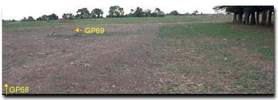 Site GP69 Landscape |
Soil Profile Morphology:
Surface Soil
| A11 | 0-10 cm | Dark brown (7.5YR3/4); sandy loam; weak structure; firm consistence dry; macropores present; pH 7.1; clear change to: | 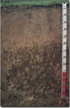 Site GP69 Profile |
| A12 | 10-45 cm | Reddish brown (5YR4/4); sandy loam; massive structure; firm consistence dry; macropores present; pH 6.2; gradual change to: | |
| A13 | 45-60 cm | Yellowish red (5YR4/6); sandy loam; massive structure; firm consistence dry; macropores present; pH 5.8; abrupt and wavy change to: | |
| Subsoil | |||
| B21 | 60-100 cm | Yellowish red (5YR4/6); light clay (fine sandy); moderate coarse prismatic, parting to strong coarse blocky structure; very firm consistence dry; contains few (2%) manganese stains; pH 6.7; gradual change to: | |
| B22 | 100-130 cm | Reddish brown (5YR4/4) with strong brown (7.5YR5/8) mottles; light clay; moderate coarse prismatic, parting to moderate coarse blocky structure; firm consistence dry; pH 7.8; clear and wavy change to: | |
| B23 | 130+ cm | Light brownish grey (2.5Y6/2) with yellowish brown (10YR5/8); silty light clay; strong coarse prismatic, parting to coarse blocky structure; very firm consistence dry; pH 8.0. | |
Key Profile Features:
- Relatively deep (60 cm) sandy loam surface soil.
- Strong texture contrast between surface (A) horizons and subsoil (B21) horizon.
Horizon | pH | Salinity Rating | ||
Surface (A1 horizon) | Slightly Alkaline | Moderate | Non-Sodic | None |
Subsoil (B21 horizon) | Slightly Acid | Low-Moderate | Sodic | None1 |
Deeper subsoil (at 1+ m) | Slightly Alkaline | Moderate | - | - |
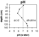 | The surface is slightly alkaline. The subsoil is slightly acid becoming slightly alkaline at 90 cm. | 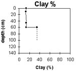 | The clay content increases significantly at the A/B horizon interface. |
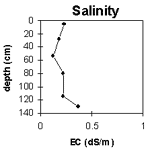 | The surface salinity rating is moderate. The subsoil is low to moderate. |
Horizon | Horizon Depth (cm) | pH (water) | pH (CaCl2) | EC 1:5 | NaCl | Exchangeable Cations | |||
Ca | Mg | K | Na | ||||||
meq/100g | |||||||||
A11 | 0-10 | 7.1 | 6.1 | 0.23 | 5.6 | 3.4 | 0.9 | 0.7 | |
A12 | 10-45 | 6.2 | 5.1 | 0.18 | 1.2 | 0.72 | 1.1 | 0.77 | |
A13 | 45-60 | 5.8 | 4.7 | 0.12 | 0.73 | 0.48 | 0.77 | 0.54 | |
B21 | 60-100 | 6.7 | 6 | 0.22 | 3.5 | 3 | 1.5 | 1 | |
B22 | 100-130 | 7.8 | 7.1 | 0.22 | |||||
B23 | 130+ | 8 | 7.4 | 0.37 | |||||
Horizon | Horizon Depth (cm) | Exchangeable Aluminium mg/kg | Exchangeable Acidity meq/100g | Field Capacity pF2.5 | Wilting Point pF4.2 | Coarse Sand (0.2-2.0 mm) | Fine Sand (0.02-0.2 mm) | Silt (0.002-0.02 mm) | Clay (<0.002 mm) |
A11 | 0-10 | 10.3 | 29 | 37 | 14 | 14 | |||
A12 | 10-45 | <10 | 4.9 | 31 | 43 | 12 | 13 | ||
A13 | 45-60 | 12 | 4.8 | 30 | 45 | 11 | 14 | ||
B21 | 60-100 | 12.6 | 3 | 38 | 24 | 35 | |||
B22 | 100-130 | ||||||||
B23 | 130+ |
Management Considerations:
Whole Profile
- Plant Available Water Capacity (PAWC) is considered to be low-moderate (estimated at 75 mm) for this soil profile. This is based on an estimated effective rooting depth of 60 cm (i.e. surface soil). The denser and more coarsely structured deeper subsoil is likely to restrict rooting depth. PAWC has been estimated using a model developed by Littleboy (1995) which uses analytical data for clay%, silt%, fine sand%, coarse sand % and wilting point.
- The surface horizons are relatively deep (60 cm) and sandy. Infiltration of water will be relatively rapid as a result. The surface soil will be well drained and provide a good environment for plant roots. This soil is likely to be well suited to spray irrigation.
- The level of soluble salts in the surface is moderate and may restrict the growth of salt sensitive species. These levels may be unnaturally high due to the effects of the dry season at the time of sampling (i.e. summer 1997) and are likely to decline following heavy rainfall and/or irrigation.
- The surface (A1) horizon has a moderate nutrient holding capacity (based on the sum of the exchangeable calcium, magnesium and potassium cations). The high levels of organic matter at this site are important for enhancing soil fertility as well as water holding capacity and surface soil structure. Nitrogen levels at this site are high which reflects the high organic matter levels.
- The dense and coarsely structured subsoil (B21) horizon is sodic and has a low exchangeable calcium to magnesium ratio (0.4). Complete dispersion occurs after remoulding. Water and root movement in the subsoil is likely to be restricted as a result of these conditions.
© State of Victoria (Agriculture Victoria) 1996 - 2025.

This work, Victorian Resources Online, is licensed under a Creative Commons Attribution 4.0 licence. You are free to re-use the work under that licence, on the condition that you credit the State of Victoria (Agriculture Victoria) as author, indicate if changes were made and comply with the other licence terms.
The licence does not apply to ‘branding’ or some ‘images or photographs’ that may be owned by third parties. We ask you to seek prior approval to use images using the VRO feedback form. Access to higher quality images can also be provided on request.
This page was last updated on 25/01/2019.