
GP68
| Location: Bundalaguah. | Australian Soil Classification: Melanic, (& Sodic) Hypocalcic, Brown CHROMOSOL. |
| Geology: Quaternary prior stream deposits. | General Landscape Description: Level plain above present flood plain (adjacent to prior stream levee bank). |
| Mapping Unit: Tinamba [This soil is equivalent to Acre clay loam as described by Skene and Walbran (1948)]. | Site Description: Dairy grazing paddock. |
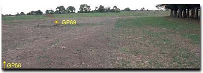 Site GP68 Landscape |
Soil Profile Morphology:
Surface Soil
| A1 | 0-10 cm | Very dark greyish brown (10YR3/2); fine sandy clay loam; moderate medium polyhedral, parting to fine polyhedral structure; very firm consistence dry; pH 5.8: | 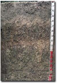 Site GP68 Profile |
| A21 | 10-30 cm | Very dark greyish brown (10YR3/2); conspicuously bleached (10YR6/2d); fine sandy clay loam; moderate medium polyhedral, parting to moderate fine polyhedral structure; rusty root channel mottling present; strong consistence dry; pH 6.4: | |
| A22 | 30-45 cm | Brown (10YR5/3); sporadically bleached; fine sandy clay loam; weak structure; strong consistence dry; pH 7.7: | |
| Subsoil | |||
| B21 | 45-80 cm | Strong brown (7.5YR5/6); medium clay; strong coarse prismatic, parting to strong coarse blocky structure; strong consistence dry; very many (50-60%) dark stains on ped faces; pH 8.1: | |
| B22 | 80-100 cm | Light reddish brown (5YR6/4); light medium clay; strong consistence dry; contains very few (1%) carbonate/silica nodules (5-10 mm in size); pH 9.0: | |
| B23 | 100+ cm | Light brownish grey (10YR6/2) with (40%) brownish yellow (10YR6/6) mottles; light medium clay; strong coarse prismatic, parting to moderate coarse blocky structure; strong consistence dry; pH 9.1. | |
- Strong texture contrast between surface (A) horizons and subsoil (B21) horizon.
- Conspicuously bleached subsurface (A2) horizon.
Horizon | pH | Salinity Rating | ||
Surface (A1 horizon) | Moderately Acid | Moderate | Non-Sodic | None |
Subsoil (B21 horizon) | Moderately Alkaline | Low | Non-Sodic | Slight1 |
Deeper Subsoil (at 1 m) | Strongly Alkaline | Moderate | Strongly Sodic | Slight1 |
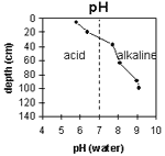 | The soil profile becomes increasingly alkaline with depth. | 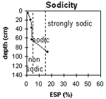 | The surface and upper subsoil is non-sodic. The deeper subsoil becomes sodic at 65 cm and strongly sodic at 85 cm depth. |
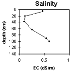 | The surface salinity rating is moderate. The subsoil rating is low becoming moderate with depth. | 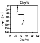 | The clay content increases significantly at the A/B horizon interface. |
Horizon | Horizon Depth (cm) | pH (water) | pH (CaCl2) | EC 1:5 | NaCl | Exchangeable Cations | |||
Ca | Mg | K | Na | ||||||
meq/100g | |||||||||
A1 | 0-10 | 5.8 | 5.3 | 0.47 | <0.03 | 13 | 4.2 | 2 | 0.1 |
A21 | 10-30 | 6.4 | 5.6 | 0.11 | 6.1 | 3 | 1.4 | 0.24 | |
A22 | 30-45 | 7.7 | 6.8 | 0.09 | 4.3 | 3.7 | 1.2 | 0.35 | |
B21 | 45-80 | 8.1 | 7.4 | 0.25 | <0.03 | 4.7 | 7.5 | 1.8 | 0.5 |
B22 | 80-100 | 9 | 8.4 | 0.54 | 0.06 | 2.5 | 8 | 0.9 | 2.3 |
B23 | 100+ | 9.1 | 8.3 | 0.6 | 0.11 | ||||
Horizon | Horizon Depth (cm) | Exchangeable Aluminium mg/kg | Exchangeable Acidity meq/100g | Field Capacity pF2.5 | Wilting Point pF4.2 | Coarse Sand (0.2-2.0 mm) | Fine Sand (0.02-0.2 mm) | Silt (0.002-0.02 mm) | Clay (<0.002 mm) |
A1 | 0-10 | <10 | 17.3 | 9 | 24 | 27 | 26 | ||
A21 | 10-30 | 11.5 | 5 | 27 | 37 | 27 | |||
A22 | 30-45 | 10.4 | 3 | 28 | 39 | 29 | |||
B21 | 45-80 | 16.4 | 2 | 20 | 28 | 49 | |||
B22 | 80-100 | 16.6 | 1 | 11 | 44 | 4 | |||
1.4B23 | 100+ |
Management Considerations:
Whole Profile
- Plant Available Water Capacity (PAWC) is considered to be moderate (estimated at 95 mm) for this soil profile. This is based on an estimated effective rooting depth of 45 cm (i.e. surface soil). The denser and more coarsely structured deeper subsoil is likely to restrict rooting depth, although not to the same extent as some of the more sodic subsoils in the region. PAWC has been estimated using a model developed by Littleboy (1995) which uses analytical data for clay%, silt%, fine sand%, coarse sand % and wilting point.
- The level of soluble salts in the surface is moderate and may restrict the growth of salt sensitive species. These levels may be unnaturally high due to the effects of the dry season at the time of sampling (i.e. summer 1997) and are likely to decline following heavy rainfall and/or irrigation.
- The surface (A1) horizon has a high nutrient holding capacity (based on the sum of the exchangeable calcium, magnesium and potassium cations). The high levels of organic matter at this site are important for enhancing soil fertility as well as water holding capacity and surface soil structure. Nitrogen levels are high reflecting the high organic matter levels at this site.
- The presence of bleaching and rusty root channel mottling in the subsurface (A2) horizon indicates that periodic waterlogging occurs above the more slowly permeable subsoil.
- The dense and coarsely structured upper subsoil is non-sodic but disperses slightly. Root and water movement will be restricted in the subsoil although not as significantly as Sodosols in the region.
© State of Victoria (Agriculture Victoria) 1996 - 2025.

This work, Victorian Resources Online, is licensed under a Creative Commons Attribution 4.0 licence. You are free to re-use the work under that licence, on the condition that you credit the State of Victoria (Agriculture Victoria) as author, indicate if changes were made and comply with the other licence terms.
The licence does not apply to ‘branding’ or some ‘images or photographs’ that may be owned by third parties. We ask you to seek prior approval to use images using the VRO feedback form. Access to higher quality images can also be provided on request.
This page was last updated on 25/01/2019.