
GP64
| Location: Riverslea. | Australian Soil Classification: Melanic-Sodic, Eutrophic, Black DERMOSOL. |
| Geology: Holocene fluvial deposits. | General Landscape Description: Level plain associated with the Thomson River. |
| Mapping Unit: Thomson. | Site Description: Grazing paddock. |
| Native Vegetation: Original vegetation included red gum (E tereticornis). | |
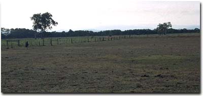 Site GP64 Landscape |
Soil Profile Morphology:
Surface Soil
| A1 | 0-10 cm | Very dark greyish brown (10YR3/2); heavy fine sandy clay loam; moderate medium polyhedral, parting to fine polyhedral structure; rusty root channel mottling present; very firm consistence dry; pH 5.6: | 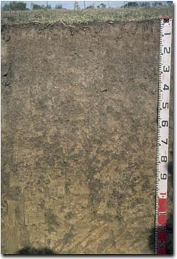 Site GP64 Profile |
| Subsoil | |||
| B21 | 10-30 cm | Very dark greyish brown (10YR3/2); heavy fine sandy clay loam; moderate medium polyhedral, parting to fine polyhedral structure; very firm consistence dry; pH 5.9: | |
| B22 | 30-60 cm | Dark brown (10YR3/3); silty clay loam; moderate coarse prismatic, parting to moderate coarse blocky structure; strong consistence dry; pH 6.0: | |
| B23 | 60-90 cm | Dark yellowish brown (10YR4/4) with dark brown (10YR3/3) mottles; fine sandy clay loam; moderate coarse prismatic structure; contains some mica; macropores present; pH 6.5: | |
| B24 | 90+ cm | Light olive brown (2.5Y5/4) with yellowish brown (10YR5/8) and brownish yellow (10YR6/6) mottles; very fine sandy clay loam; contains mica; many macropores present; pH 8.7. | |
Key Profile Features:
- Lack of strong texture contrast between surface (A) horizons and subsoil (B2) horizon.
- Well structured surface soil and upper subsoil (parting to strong fine polyhedral structure).
Horizon | pH | Salinity Rating | ||
Surface (A1 horizon) | Moderately Acid | Low | Non-sodic | None |
Subsoil (B21 horizon) | Moderately Acid | Low | Non-sodic | None |
Deeper subsoil (at 90 cm) | Strongly Alkaline | Moderate | Strongly Sodic | Slight1 |
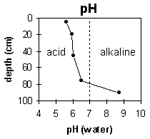 | The surface and upper subsoil is moderately acid. The deeper subsoil is strongly alkaline. | 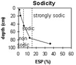 | The surface and upper subsoil is non-sodic. The subsoil becomes sodic at 45 cm and strongly sodic at 80 cm. |
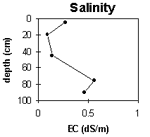 | The surface salinity rating is low to moderate. The upper subsoil rating is low becoming moderate with depth | 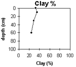 | The clay content gradually decreases with depth. |
Horizon | Horizon Depth (cm) | pH (water) | pH (CaCl2) | EC 1:5 | NaCl | Exchangeable Cations | |||
Ca | Mg | K | Na | ||||||
meq/100g | |||||||||
A1 | 0-10 | 5.6 | 5 | 0.27 | <0.03 | 10 | 5.5 | 0.4 | 0.3 |
B21 | 10-30 | 5.9 | 5 | 0.09 | 6.1 | 5.3 | 0.3 | 0.5 | |
B22 | 30-60 | 6 | 5.2 | 0.14 | 3.7 | 5.6 | 0.16 | 0.67 | |
B23 | 60-90 | 6.5 | 5.8 | 0.56 | 0.12 | 2.2 | 5.6 | 0.1 | 1.1 |
B24 | 90+ | 8.7 | 7.7 | 0.49 | 0.1 | 1.5 | 4.1 | 0.1 | 1.1 |
Horizon | Horizon Depth (cm) | Exchangeable Aluminium mg/kg | Exchangeable Acidity meq/100g | Field Capacity pF2.5 | Wilting Point pF4.2 | Coarse Sand (0.2-2.0 mm) | Fine Sand (0.02-0.2 mm) | Silt (0.002-0.02 mm) | Clay (<0.002 mm) |
A1 | 0-10 | <10 | 16 | 18.4 | 3 | 19 | 34 | 33 | |
B21 | 10-30 | <10 | 11 | 15.2 | 3 | 27 | 29 | 35 | |
B22 | 30-60 | <10 | 1.9 | 11.4 | 4 | 37 | 28 | 29 | |
B23 | 60-90 | 10.5 | 2 | 49 | 25 | 24 | |||
B24 | 90+ | 10.8 |
Management Considerations:
Whole Profile
- Plant Available Water Capacity (PAWC) is considered to be low-moderate (estimated at 70 mm) for this soil profile. This is based on an estimated effective rooting depth of 30 cm (i.e. surface soil and upper subsoil). The denser and more coarsely structured deeper subsoil is likely to restrict rooting depth, although not as significantly as some of the more sodic subsoils in the region. Therefore, effective PAWC could be considered to be more than 70 mm when compared to many of the more sodic and denser subsoils in the region. PAWC has been estimated using a model developed by Littleboy (1995) which uses analytical data for clay %, silt %, fine sand %, coarse sand % and wilting point.
- Infiltration of water will be rapid throughout the upper soil profile due to the well developed structure and pore space available.
- The level of soluble salts in the surface is low to moderate. These levels may be unnaturally high due to the effects of the dry season at the time of sampling (i.e. summer 1997) and are likely to decline following heavy rains and/or irrigation.
- The surface (A1) horizon has a moderate nutrient holding capacity (based on the sum of the exchangeable calcium, magnesium and potassium cations). The high levels of organic matter at this site are important for enhancing soil fertility, water holding capacity and enhancing surface soil structure. Nitrogen levels are quite high at this site, also reflecting the high organic matter levels.
- The surface soil is well structured (parting to many fine polyhedral shaped peds). This will be beneficial for plant root development.
- The upper subsoil is well structured (parting to many fine polyhedral shaped peds) which will promote root and water movement. Many macropores were also evident which will enhance water movement.
- The more coarsely structured deeper subsoil (from 30 cm depth) is sodic and has a low exchangeable calcium to magnesium ratio (0.7). Slight dispersion occurs only after remoulding. The subsoil is strongly sodic at 80 cm with increased dispersion and becomes extremely sodic at 90 cm depth. These conditions are likely to result in more restricted root and water movement in the deeper subsoil.
© State of Victoria (Agriculture Victoria) 1996 - 2025.

This work, Victorian Resources Online, is licensed under a Creative Commons Attribution 4.0 licence. You are free to re-use the work under that licence, on the condition that you credit the State of Victoria (Agriculture Victoria) as author, indicate if changes were made and comply with the other licence terms.
The licence does not apply to ‘branding’ or some ‘images or photographs’ that may be owned by third parties. We ask you to seek prior approval to use images using the VRO feedback form. Access to higher quality images can also be provided on request.
This page was last updated on 25/01/2019.