
GP62
| Location: Cowwarr. | Australian Soil Classification: Melanic, Eutrophic, Black DERMOSOL. |
| Geology: Holocene fluvial deposits. | General Landscape Description: Level plain (0-1% slope). |
| Mapping Unit: Thomson. | Site Description: Dairy grazing paddock. |
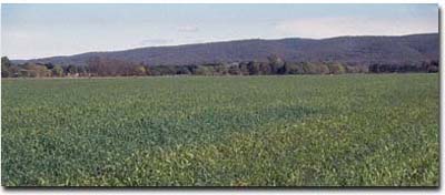 Site GP62 Landscape |
Soil Profile Morphology:
Surface Soil
| A11 | 0-25 cm | Very dark greyish brown (10YR3/2); fine sandy loam; strong medium polyhedral, parting to fine polyhedral structure; weak consistence dry; pH 5.7; gradual change to: | 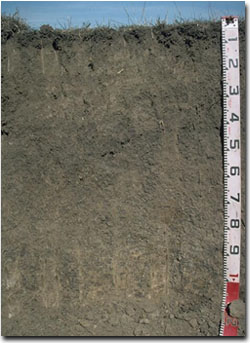 Site GP62 Profile |
| A12 | 25-40 cm | Very dark greyish brown (10YR3/2); fine sandy clay loam; strong medium polyhedral, parting to fine polyhedral structure; firm consistence dry; pH 6.4; gradual change to: | |
| Subsoil | |||
| B21 | 40-60 cm | Very dark brown (10YR2/2); light clay; weak coarse prismatic, parting to strong medium to fine polyhedral structure; very firm consistence dry; pH 5.9; gradual change to: | |
| B22 | 60-100 cm | Dark brown (10YR3/3) (with a bleached appearance on some ped faces); light clay (silty); moderate coarse prismatic, parting to strong medium polyhedral structure; strong consistence dry; pH 5.8; gradual change to: | |
| B23 | 100-120 cm | Dark greyish brown (10YR4/2) with brown (7.5YR4/4) mottles and a bleached appearance on some ped faces; light clay silty; moderate coarse prismatic, parting to strong coarse polyhedral structure; strong consistence dry; manganese stains common; pH 6.6. | |
Key Profile Features:
- Gradual increases in clay content with depth.
- Well structured surface and upper subsoil.
Horizon | pH | Salinity Rating | ||
Surface (A1 horizon) | Moderately Acid | Moderate | Non-sodic | None |
Subsoil (B21 horizon) | Moderately Acid | Very Low | Non-sodic | None |
Deeper subsoil (at 1 m) | Slightly Acid | Very Low | Non-sodic | None |
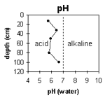 | The surface and upper subsoil is moderately acid. The deeper subsoil becomes slightly acid. | 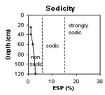 | The profile is non-sodic throughout. |
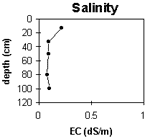 | The surface salinity rating is moderate. The subsoil salinity rating is very low throughout. | 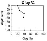 | The clay content increases gradually with depth. |
Horizon | Horizon Depth
(cm) | pH
(water) | pH
(CaCl2) | EC 1:5 | NaCl | Exchangeable Cations | |||
Ca | Mg | K | Na | ||||||
meq/100g | |||||||||
A11 | 0-25 | 5.7 | 5.1 | 0.22 | 10 | 2.9 | 0.24 | 0.29 | |
A12 | 25-40 | 6.4 | 5.6 | 0.09 | 8.3 | 4.4 | 0.14 | 0.29 | |
B21 | 40-60 | 5.9 | 4.9 | 0.09 | 5.7 | 6.1 | 0.14 | 0.44 | |
B22 | 60-100 | 5.8 | 4.8 | 0.08 | 4.1 | 6.1 | 0.13 | 0.42 | |
B23 | 100-120 | 6.6 | 5.5 | 0.1 | |||||
Horizon | Horizon Depth (cm) | Exchangeable Aluminium mg/kg | Exchangeable Acidity meq/100g | Field Capacity pF2.5 | Wilting Point pF4.2 | Coarse Sand (0.2-2.0 mm) | Fine Sand (0.02-0.2 mm) | Silt (0.002-0.02 mm) | Clay (<0.002 mm) |
A11 | 0-25 | <10 | 11 | 10.9 | 2 | 52 | 19 | 18 | |
A12 | 25-40 | -28 | 8.7 | 12.2 | 2 | 41 | 25 | 25 | |
B21 | 40-60 | <10 | 11 | 16.3 | 2 | 17 | 36 | 39 | |
B22 | 60-100 | <10 | 3.4 | 15.4 | 2 | 18 | 38 | 38 | |
B23 | 100-120 |
Management Considerations:
Whole Profile
- Plant Available Water Capacity (PAWC) is considered to be moderate-high (estimated at 130 mm) for this soil profile. This is based on an estimated effective rooting depth of 60 cm (ie. surface soil and upper subsoil). The denser and more coarsely structured deeper subsoil is likely to restrict rooting depth, although not as significantly as some of the more sodic subsoils in the region. PAWC has been estimated using a model developed by Littleboy (1995) which uses analytical data for clay %, silt %, fine sand %, coarse sand % and wilting point.
- Infiltration of water will be rapid throughout the upper soil profile due to the well developed structure and pore space available.
- The level of soluble salts in the surface is moderate and may restrict the growth of salt sensitive species. These levels may be unnaturally high due to the effects of the dry season at the time of sampling (1996/97) and are likely to decline following heavy rainfall and/or irrigation.
- The relatively deep surface soil is well structured (parting to many fine polyhedral shaped peds) and is friable when moist. Soil consistence when moist is also weak for this horizon. As a result of these attributes the surface soil will provide excellent seed-bed conditions, creating few limitations to root and water movement.
- The surface (A1) horizon has a moderate nutrient holding capacity (based on the sum of the exchangeable calcium, magnesium and potassium cations).
- The surface soil has a very high fine sand content (ie. 50%). Soils such as these rely on organic matter to maintain soil structure. Maintaining organic matter levels will also assist in improving soil fertility and water holding capacity.
- Infiltration of water into the well structured surface soil will be quite high and this horizon will be well drained.
- The upper subsoil is well structured (parting to many fine polyhedral shaped peds). Root and water movement is not likely to be significantly restricted as a result.
- The deeper subsoil (from 60 cm depth) becomes more coarsely structured and will be more restrictive to root movement.
© State of Victoria (Agriculture Victoria) 1996 - 2025.

This work, Victorian Resources Online, is licensed under a Creative Commons Attribution 4.0 licence. You are free to re-use the work under that licence, on the condition that you credit the State of Victoria (Agriculture Victoria) as author, indicate if changes were made and comply with the other licence terms.
The licence does not apply to ‘branding’ or some ‘images or photographs’ that may be owned by third parties. We ask you to seek prior approval to use images using the VRO feedback form. Access to higher quality images can also be provided on request.
This page was last updated on 25/01/2019.