GP88
Location: Moondarra South
Australian Soil Classification: Bleached-mottled, Magnesic, Grey KUROSOL
Map Unit: Boolarra
Soil Type (equivalent to): Boolarra Loam (Poutsma and Turvey, 1979)
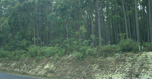
General Landscape Description: Crest of rolling low hills.
Site Description: Roadside reserve.
Geology: Moondarra Surface
Native Vegetation: Silvertop Ash (E. Sieberi)

GP88 Landscape.
Soil Profile Morphology:
Surface Soil
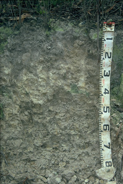
| A1 | 0-15 cm | Dark grey (10YR4/1); silty clay loam; very firm consistence dry; pH 5.1; clear change to:
|  GP88 Profile |
| A2 | 15-40 cm | Very pale brown (10YR7/3) with few (5-10%) yellow (10YR7/6) mottles; silty clay loam; pH 5.3; clear change to: | |
| Subsoil | |||
| B21 | 40-80 cm | Light grey (10YR7/1) with few (10%) brownish yellow (10YR6/6) mottles; light medium clay (silty); strong coarse blocky parting to moderate coarse polyhedral structure; pH 5.3. | |
Soil Profile Characteristics:
pH | Salinity Rating | |||
Surface (A1 horizon) | Strongly Acid | Very Low | Non-Sodic | None |
Subsoil (B21 horizon) | Strongly Acid | Very Low | Non-Sodic | None |

| This profile is strongly acid throughout. | The salinity rating is very low though the whole profile. | The aluminium levels are high throughout the profile. |
|
Horizon | Horizon Depth (cm) | pH (water) | pH CaCl2 | EC (dS/m) | Exchangeable Cations | |||
Ca | Mg | K | Na | |||||
meq/100g | ||||||||
A1 | 0-15 | 5.1 | 4.1 | 0.06 | 1.1 | 1.0 | <0.1 | 0.1 |
A2 | 15-40 | 5.3 | 4.3 | <0.05 | 0.3 | 0.9 | <0.1 | <0.1 |
B21 | 40-80 | 5.3 | 4.2 | <0.05 | 0.2 | 2.0 | <0.1 | <0.1 |
Horizon | Horizon Depth (cm) | Acidity meq/100g | Oxidisable Organic Carbon % | Exchangeable Aluminium mg/kg | Field Capacity pF2.5 | Wilting Point pF4.2 | Coarse Sand (0.2-2.0 mm) | Fine Sand (0.02-0.2 mm) | Silt (0.002-0.02 mm) | Clay (<0.002 mm) |
A1 | 0-15 | 12 | 1.4 | 270 | 28.0 | 5.5 | 3.6 | 33.5 | 44.5 | 13.0 |
A2 | 15-40 | 6.7 | 250 | 23.7 | 7.4 | 2.2 | 27.5 | 48.0 | 22.0 | |
B21 | 40-80 | 8.2 | 310 | 32.8 | 18.9 | 0.4 | 11.3 | 37.0 | 52.0 |
Profile Described By: Mark Imhof and Ian Sargeant (January 1999).


