
GP45
| Location: Darriman. | Australian Soil Classification: Basic, Regolithic, Bleached-Orthic, TENOSOL/ Grey SODOSOL (thick sandy surface horizons). |
| Geology: Pleistocene and Recent alluvium associated with Morris Creek. | General Landscape Description: Undulating plain (1-2% slope). Possibly a sand sheet or levee. |
| Soil Mapping Unit: Woodside. | Site Description: Grazing paddock. |
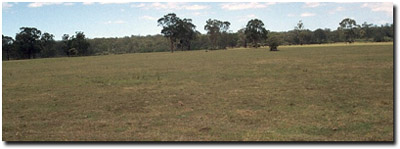 Site GP45 Landscape |
Soil Profile Morphology:
Surface Soil
| A1 | 0-15 cm | Very dark grey (10YR3/1); loamy sand; weak coarse polyhedral, parting to weak medium polyhedral structure; weak consistence dry; pH 6.5; clear change to: | 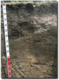 Site GP45 Profile |
| A2 | 15-35 cm | Dark greyish brown (10YR4/2), conspicuously bleached (10YR7/2d) with faint yellowish brown (10YR5/6) mottles; loamy sand; massive structure; firm consistence dry; contains few (10%) subrounded quartz fragments (2-5 mm in size); pH 6.5; clear and wavy change to: | |
| A3 | 35-55 cm | Brown (10YR5/3) with yellowish red (10YR5/6) mottles; loamy sand; massive structure; strong consistence dry; contains few (5-10%) sub-rounded quartz fragments (2-5 mm in size); roots to 40 cm; pH 6.9: | |
| Subsoil | |||
| B21 | 55-110 cm | Dark grey (10YR4/1) with yellowish brown (10YR5/6), dark brown (10YR2/2), and very dark grey (10YR3/1) mottles; clayey coarse sand; massive structure; weak consistence moist; contains many (25%) rounded quartz fragments (2-5 mm in size); pH 7.6: | |
| Buried Subsoil | |||
| 2B2 | 110-130 cm | Grey (10YR6/1) with yellowish brown (10YR5/8) mottles; fine sandy clay; moderate coarse prismatic, parting to moderate coarse polyhedral structure; firm consistence moist; contains very few (< 2%) quartz fragments (2-5 mm in size); pH 8.0: | |
| BC | 130+ cm | Grey (10YR5/1) with yellowish brown (10YR5/8) mottles; sandy loam; weak structure. | |
Key Profile Features:
- High sand and quartz content in upper 1 metre of soil profile.
- Conspicuously bleached A2 horizon.
- The more recent sandy alluvial deposits at this site are overlying a clayey subsoil of an older soil (Grey Sodosol).
pH | Salinity Rating | |||
Surface (A1 horizon) | Slightly Acid | Very Low | Non-Sodic | None |
Subsoil (B21 horizon) | Slightly Alkaline | Low | _ | _ |
Deeper subsoil (2B2 at 1.1 m) | Moderately Alkaline | Moderate | Strongly Sodic | Complete |
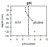 | 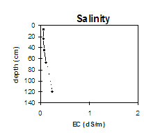 | 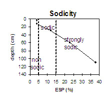 | 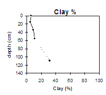 |
The surface soil is slightly acid. The subsoil is slightly alkaline becoming moderately alkaline by 1.2 m depth. | The salinity rating is very low in the surface soil and upper subsoil. The salinity rating for the deeper subsoil becomes moderate. | The clay content is low in the upper metre of the soil profile and then increases significantly. |
Horizon | Horizon Depth (cm) | pH (water) | pH (CaCl2) | EC 1:5 | NaCl | Exchangeable Cations | |||
Ca | Mg | K | Na | ||||||
meq/100g | |||||||||
A1 | 0-15 | 6.5 | 5.9 | 0.06 | 6.8 | 1.2 | 0.1 | 0.28 | |
A2 | 15-35 | 6.5 | 5.3 | 0.07 | 2 | 1.2 | 0.07 | 0.45 | |
12A2 | 35-55 | 6.9 | 5.8 | 0.08 | 1.7 | 1.6 | 0.07 | 0.57 | |
B21 | 55-110 | 7.6 | 6.4 | 0.11 | 1.6 | 2.3 | 0.08 | 0.94 | |
2B2 | 110-130 | 8 | 6.7 | 0.25 | 0.03 | 2 | 5.2 | 0.19 | 4.5 |
BC | 130+ | ||||||||
Horizon | Horizon Depth (cm) | Exchangeable Aluminium mg/kg | Exchangeable Acidity meq/100g | Field Capacity pF2.5 | Wilting Point pF4.2 | Coarse Sand (0.2-2.0 mm) | Fine Sand (0.02-0.2 mm) | Silt (0.002-0.02 mm) | Clay (<0.002 mm) |
A1 | 0-15 | 6.3 | 43 | 36 | 9 | 6 | |||
A2 | 15-35 | 2.9 | 47 | 37 | 12 | 5 | |||
A2 | 35-55 | 3.4 | 47 | 37 | 10 | 9 | |||
B21 | 55-110 | 4.7 | 66 | 20 | 4 | 11 | |||
2B2 | 110-130 | 14.6 | 20 | 35 | 15 | 32 | |||
BC | 130+ |
Management Considerations:
Whole Profile
- Plant available water capacity (PAWC) is considered to be very low (estimated at 45 mm) for the upper 35 cm of the soil profile. This is based on available laboratory data and assumes an effective rooting depth of 35 cm. Effective rooting depth will be restricted by the massive and dense horizons below this depth. PAWC has been estimated here using a model developed by Littleboy (1995) which uses analytical data for clay %, fine sand %, silt %, coarse sand % and wilting point value.
- The low wilting point value (6.3%) of the surface (A1) horizon indicates that plants will be able to utilise very light rains when the soil is dry. However, due to the low water storage capacity, plants will soon suffer moisture stress unless further rains occur.
- The surface (A1) horizon has a moderate inherent fertility, high organic matter and exchangeable calcium as well as moderate nitrogen levels. Accordingly, the (A1) horizon is the most important part of the profile for plant growth. The subsurface (A2 and A3) horizons have a very low inherent fertility.
- All the surface horizons have a high sand (80%) content and infiltration rates will be quite high.
- The presence of a conspicuous bleach in the surface (A2) horizon indicates periodic waterlogging above the more slowly permeable subsoil.
- Root movement will be restricted by the hard and massive coarse sandy deeper surface (A3) horizon. Plant roots were not observed below 40 cm in the soil pit.
- The upper subsoil (B21) horizon has a low inherent fertility and is made up of 86% sand.
- The buried subsoil (2B2) horizon is strongly sodic (and has a low exchangeable calcium to magnesium ratio) and disperses completely. This will restrict the movement of water deeper in the profile (i.e. past 1 metre).
- The buried subsoil is moderately alkaline. Alluvium derived from Tertiary (Miocene) limestone in the area may have contributed to these relatively high pH values.
- The level of soluble salts is moderate in the deeper subsoil (i.e. from 110 cm depth). This is only likely to restrict the growth of deeper-rooted salt sensitive species.
- The presence of mottling throughout the subsoil indicates that the profile is seasonally waterlogged.
© State of Victoria (Agriculture Victoria) 1996 - 2025.

This work, Victorian Resources Online, is licensed under a Creative Commons Attribution 4.0 licence. You are free to re-use the work under that licence, on the condition that you credit the State of Victoria (Agriculture Victoria) as author, indicate if changes were made and comply with the other licence terms.
The licence does not apply to ‘branding’ or some ‘images or photographs’ that may be owned by third parties. We ask you to seek prior approval to use images using the VRO feedback form. Access to higher quality images can also be provided on request.
This page was last updated on 25/01/2019.