
GP40
| Location: Yarram West. | Australian Soil Classification: Endoacidic, Self-mulching, Black VERTOSOL. |
| Geology: Recent alluvial deposits from Jack River. | General Landscape Description: Undulating elevated plain (1-2% slope). |
| Soil Mapping Unit: Riverine. | Site Description: Pasture paddock. |
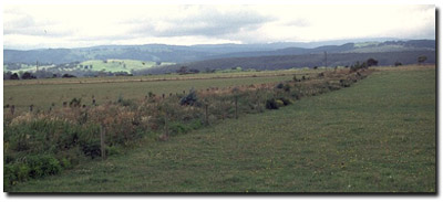 Site GP40 Landscape |
Soil Profile Morphology:
Surface Soil
| A1 | 0-5 cm | Very dark grey (10YR3/1); fine sandy clay; moderate very fine granular structure; very weak consistence dry; organic rich root mat; pH 5.4; smooth change to: | 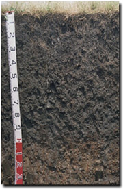 Site GP40 profile |
| Subsoil | |||
| B21 | 5-20 cm | Dark grey (10YR4/1) with rusty root channel mottling; light medium clay; moderate coarse prismatic, parting to moderate subangular blocky structure; very firm consistence dry; pH 5.5; clear change to: | |
| B22 | 20-50 cm | Black (10YR2/1) with faint dark yellowish brown (10YR4/6) mottles; medium clay; strong medium prismatic, parting to strong fine subangular blocky structure; very firm consistence dry; contains very few (<1%) manganese segregations; pH 5.6; gradual change to: | |
| B23 | 50-100 cm | Very dark grey (10YR3/1) with faint dark yellowish brown (10YR4/6) mottles; heavy clay; strong coarse prismatic, parting to strong medium sub-angular blocky structure; very firm consistence moist; contains very few (<1%) manganese segregations; pH 5.5: | |
| B24 | 100-140 cm | Dark grey (10YR4/1) with strong brown (7.5YR4/6) mottles, as well as mottling down root channels; heavy clay; strong coarse prismatic, parting to strong medium angular blocky structure; firm consistence moist; contains few (<5%) subrounded manganese nodules (5 mm size); pH 5.2. | |
Key Profile Features:
- High clay content throughout soil profile.
- High organic matter levels in the upper soil profile.
Soil Profile Characteristics:
pH | Salinity Rating | |||
Surface (A1 horizon) | Strongly Acid | Low | Non-Sodic | None |
Subsoil (B21 horizon) | Strongly Acid | Low | Non-Sodic | None1 |
Deeper subsoil (at 1 m) | Strongly Acid | Low | Non-Sodic | None1 |
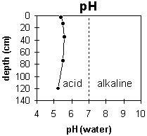 | 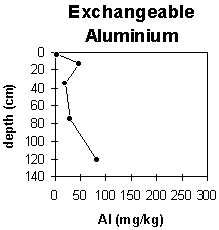 |
Most of the profile is strongly acid. | The exchangeable aluminium levels are low throughout most of the profile but increase in the strongly acid subsoil. |
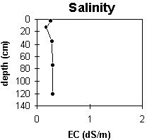 | 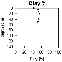 |
The salinity rating is low throughout the profile. | The clay content is high throughout the profile. |
Horizon | Horizon Depth (cm) | pH (water) | pH (CaCl2) | EC 1:5 | NaCl | Exchangeable Cations | |||
Ca | Mg | K | Na | ||||||
meq/100g | |||||||||
A1 | 0-5 | 5.4 | 4.9 | 0.26 | <0.03 | 11 | 8.8 | 1.3 | 1.5 |
B21 | 5-20 | 5.5 | 4.7 | 0.17 | 7.8 | 7.7 | 0.51 | 1.5 | |
B22 | 20-50 | 5.6 | 4.9 | 0.28 | 0.05 | 7 | 7.5 | 0.64 | 1.6 |
B23 | 50-100 | 5.5 | 4.8 | 0.29 | 0.04 | 6.8 | 7.7 | 0.54 | 1.6 |
B24 | 100-140 | 5.2 | 4.5 | 0.3 | |||||
Horizon | Horizon Depth (cm) | Exchangeable Aluminium mg/kg | Exchangeable Acidity meq/100g | Field Capacity pF2.5 | Wilting Point pF4.2 | Coarse Sand (0.2-2.0 mm) | Fine Sand (0.02-0.2 mm) | Silt (0.002-0.02 mm) | Clay (<0.002 mm) |
A1 | 0-5 | <10 | 23 | 36.1 | 3 | 4 | 28 | 42 | |
B21 | 5-20 | 47 | 20 | 27.8 | 0 | 3 | 32 | 52 | |
B22 | 20-50 | 21 | 25 | 28.2 | 0 | 2 | 32 | 55 | |
B23 | 50-100 | 29 | 17 | 25.7 | 0 | 4 | 36 | 52 | |
B24 | 100-140 | 82 |
Management Considerations:
Whole Profile
- Plant available water capacity (PAWC) is considered to be moderate (estimated at 125 mm) for the top metre of the soil profile. PAWC has been estimated using a model developed by Littleboy (1995) which uses analytical data for clay %, silt %, fine sand %, coarse sand % and wilting point value.
- Within the strongly acid surface (A1) horizon, the level of exchangeable aluminium is very low (<10 mg/kg). These levels are unlikely to affect plant growth. A pH/aluminium test on a bulked sample (from across the paddock) would be most appropriate to determine if lime is needed to raise soil pH.
- Deficiencies in molybdenum, potassium and phosphorus are likely to occur in strongly acid soils. If lime is required, an application may assist in alleviating molybdenum deficiency and will increase phosphorus availability, as well as increasing soil pH.
- Tillage or overstocking of clay soils should be avoided if the soil is wet (i.e. wetter than the plastic limit). At such moisture conditions, tillage or over-stocking could result in structural damage e.g. compaction, smearing occurring. Ideally, tillage and trafficking should take place when the soil is drier than the plastic limit down to at least the depth of tillage.
- A high wilting point indicates that water is ‘held tightly’ by the soil. The water available to plants decreases as the water content approaches this point. This surface soil has a very high wilting point value (i.e. 36%). If the soil dries out, then small falls of rain may not be sufficient to wet the soil above permanent wilting point.
- The inherent fertility (based on the sum of the exchangeable calcium, magnesium and potassium cations) is very high. Organic carbon and total nitrogen levels are also very high. The high clay content and organic matter levels contribute to the high nutrient holding capacity of these soils.
- The subsoil has vertic properties which indicates that significant shrinking and swelling occurs during wetting-drying cycles. This can disrupt the roots of perennial plants and will have implications for engineering applications (e.g. building foundations and fence lines).
- Subsoil permeability will be restricted when the soil is wet due to clay swelling. However, the subsoil is non-sodic (only slightly dispersive after remoulding) and well structured which will promote water and root movement.
- Maize and sorghum have been grown here.
© State of Victoria (Agriculture Victoria) 1996 - 2025.

This work, Victorian Resources Online, is licensed under a Creative Commons Attribution 4.0 licence. You are free to re-use the work under that licence, on the condition that you credit the State of Victoria (Agriculture Victoria) as author, indicate if changes were made and comply with the other licence terms.
The licence does not apply to ‘branding’ or some ‘images or photographs’ that may be owned by third parties. We ask you to seek prior approval to use images using the VRO feedback form. Access to higher quality images can also be provided on request.
This page was last updated on 25/01/2019.