
CFTT20
Location: Stockdale
Australian Soil Classification: Bleached, Magnesic, Brown KUROSOL
Great Soil Group: soloth
Map Unit: Stockdale
Previous Site Name: EG252, CFTT20
General Landscape Description: Gently undulating plain.
Site description: 1% slope to north-west
Land Use: Plantation timber (pines and eucalypts)
Native Vegetation: Lowland forest
Geology: Late Tertiary sediments

CFTT20 Landscape
Soil Profile Morphology:
Surface Soil
| A1 | 0 – 15 cm | Dark greyish brown (10YR4/2); fine sandy loam; weak fine (<5 mm) granular structure; very weak consistencemoist; pH5.5; clear and smooth change to: | 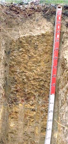 CFTT20 Profile |
| A2 | 15 – 30 cm | Pale brown (10YR6/3) conspicuously bleached (10YR7/3d); loamy fine sand; weak medium polyhedral structure; loose consistence dry; pH 5.7; sharp and wavy change to: | |
Subsoil | |||
| B21 | 30 – 80 cm | Yellowish brown (10YR5/4) with many coarse prominent brown (7.5YR4/4) mottles; medium heavy clay; strong coarse sub-angular blocky structure; parting to strong medium sub-angular blocky structure; strong consistence moist; pH 5.5; diffuse and smooth transition to: | |
| B22 | 80 – 120 cm | Light grey (10YR6/1) with many coarse strong brown (7.5YR4/6) and red (2.5YR4/6) mottles; medium heavy clay; strong coarse subangular blocky structure; parting to strong fine angular blocky structure; strong consistence moist; pH 5.3; clear and smooth transition to: | |
| BC | 120 – 160 cm | Light grey (10YR6/1) with many coarse distinct strong brown (7.5YR4/6) and red (2.5YR4/6) mottles; light clay (sandy); massive; strong consistence moist. Soft sandstone continues to at least 2 m in depth. |
Key Profile Features:
- Strong texture contrast between the sand surface (A) horizons and the clay subsoil (B21) horizon.
- Conspicuously bleached A2 horizon.
Soil Profile Characteristics:
pH | Salinity Rating | |||
Surface (A1 horizon) | Strongly Acid | Very Low | - | - |
Subsoil (B21 horizon) | Strongly Acid | Very Low | Non-sodic | - |
Deeper Subsoil (at 1 m) | Strongly Acid | Very Low | Non-sodic | - |
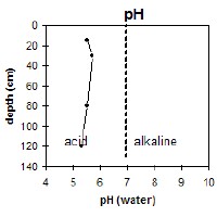 The soil profile is strongly acid throughout. | 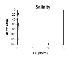 The level of soluble salts is very low throughout the profile. | 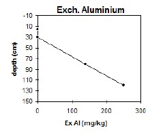 The level of exchangeable aluminium becomes high in the subsoil. | 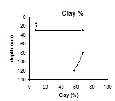 The clay content increases significantly at the A/B horizon interface. |
Horizon | Horizon Depth (cm) | pH (water) | pH (CaCl2) | EC dS/m | Exchangeable Cations | |||
Ca | Mg | K | Na | |||||
Meq/100g | ||||||||
A1 | 0-15 | 5.5 | 4.7 | 0.07 | 3.7 | 1.6 | 0.17 | 0.14 |
A2 | 15-30 | 5.7 | 4.8 | <0.05 | 0.72 | 0.87 | 0.08 | 0.06 |
B21 | 30-80 | 5.5 | 4.5 | 0.08 | 0.76 | 9.2 | 0.35 | 0.76 |
B22 | 80-120 | 5.3 | 4.3 | 0.08 | 0.37 | 7.7 | 0.22 | 0.86 |
Horizon | Horizon Depth (cm) | Exchangeable Aluminium mg/kg | Exchangeable Acidity meq/100g | Field Capacitiy pF 2.5 | Wilting Point pF4.2 | Coarse Sand (0.2-2.0mm) % | Fine Sand (0.02-0.2mm) % | Silt (0.002-0.02mm) % | Clay (<0.002mm) % |
A1 | 0-15 | <10 | 8.9 | 15.9 | 5 | 29 | 49 | 9.5 | 9 |
A2 | 15-30 | <10 | 3.4 | 14.2 | 2.9 | 29.4 | 51.6 | 10 | 8 |
B21 | 30-80 | 140 | 12 | 46 | 25.9 | 10.1 | 15.6 | 2.5 | 68 |
B22 | 80-120 | 250 | 12 | 38.6 | 22 | 9.3 | 26.5 | 6.5 | 57.5 |
Management Considerations:
Whole Profile
- The plant available water capacity of this soil is considered to be low (estimated at 52 mm) for the top 40 cm of this profile. The high clay content and coarse structure of the B21 horizon would limit root growth in pasture species.
- The levels of exchangeable aluminium become reasonably high in the strongly acid subsoil. This may restrict growth in aluminium sensitive species.
- Availability of some trace elements (eg copper, molybdenum) may be low in the mainly strongly acidic profile.
Surface (A) horizons
- The surface (A1) horizon is extremely acid but the pastures are unlikely to show any response to lime.
- The sandy surface horizons are very well draining and have a low water storage capacity. The low wilting points (i.e. 5 and 2.1%) indicate plants will be able to utilise light rains falling on dry soil. However, due to the low water storage capacity, plants will soon suffer moisture stress unless further rain occurs. Organic matter is an important source of nutrient holding capacity as well as enhancing water holding capacity in sandy soils.
- The sandy surface soil will also be prone to wind erosion if plant cover is removed where blow-outs can occur.
- The surface horizons have a very low inherent fertility (based on the sum of the exchangeable cations).
- The soil is below deficiency level for potassium and a response to potassium fertilisers would be expected provided the phosphorus levels are adequate.
Subsoil (B) horizon
- The dense and coarsely structured upper (B21) subsoil is non-sodic. However the high clay content will restrict the downward movement of plant roots and water. The temporary build up of water on top of this less permeable layer may be beneficial for deeper-rooted plants as it prevents deep drainage of water away from plant roots.
- The upper (B21) subsoil has a relatively moderate inherent fertility throughout (based on the sum of the exchangeable calcium, magnesium and potassium cations). The cations are dominated by exchangeable magnesium which may create nutrient imbalances.
- The level of soluble salts is low throughout the soil profile.
- The levels of exchangeable aluminium become reasonably high in the strongly acid subsoil. This may restrict the growth of aluminium sensitive species.
Notes:
- A shallow version of Stockdale.
Tech. Class: 052-6-50/2-1-3-32
Profile Surveyed By: Ian Sargeant and Justin Wong (June 1999)
© State of Victoria (Agriculture Victoria) 1996 - 2025.

This work, Victorian Resources Online, is licensed under a Creative Commons Attribution 4.0 licence. You are free to re-use the work under that licence, on the condition that you credit the State of Victoria (Agriculture Victoria) as author, indicate if changes were made and comply with the other licence terms.
The licence does not apply to ‘branding’ or some ‘images or photographs’ that may be owned by third parties. We ask you to seek prior approval to use images using the VRO feedback form. Access to higher quality images can also be provided on request.
This page was last updated on 25/01/2019.