
SFS1
Location: Gnarwarre, 'South Roxby'
Aust. Soil Class.: Vertic (& Sodic), Self-mulching, Grey VERTOSOL
General Landscape Description: Plain
Site Description: Old proposed SFS 'environmental' research site
Geology: Quaternary - Newer Volcanics
Mapping Unit: Gnarwarre B soil (after Adcock)
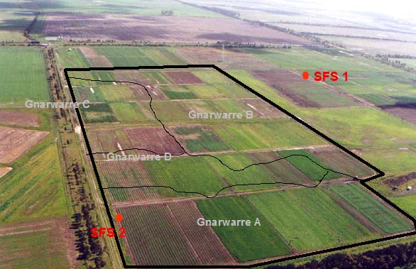
SFS 1 (Mapping units within the Gnarwarre SFS Farming Systems trial site)
Soil Profile Morphology:
| Surface Soil |  SFS 1 | ||
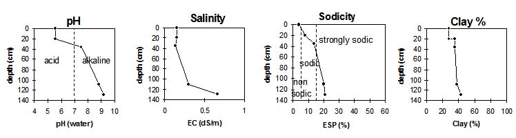
| Ap | 0-20 cm | Very dark greyish brown (10YR 3/2 moist), dark greyish brown (10YR 4/2 dry); light clay (fine sandy), strong, fine (5-15 mm) polyhedral structure; pH 5.6; abrupt change to: | |
| Subsoil | |||
| B21g | 15-35 cm | Dark grey (10YR 4/1 moist) with many (~50%) yellowish brown (10YR 5/8 moist) mottles; black (10YR 2/1 moist) infill in cracks; heavy clay; very coarse angular blocky and polyhedral structure; cracks; pH 7.5; gradual and irregular change to: | |
| B22(k?) | 50/70-100/110 cm | Dark grey (2.5Y 4/1 moist) with greyish brown (2.5Y 5/2 moist) mottles; medium clay; occasional patches of soft calcium carbonate, audible effervescence, bubbles < 2 mm; very coarse to coarse (20-80 mm) lenticular peds; slickensides; pH 8.8; clear change to: | |
| B23k | 100/110 cm+ | Dark greyish brown (2.5Y 4/2 moist); light clay to light medium clay; calcium carbonate present; basalt floaters present at 120 cm; pH 9.2. | |
Key Profile Features:
Soil Profile Characteristics:
pH | Salinity Rating | |||
Surface (A1 horizon) | Moderately Acid | Low | Non-sodic | None1 |
Subsoil (B21 horizon) | Slightly Alkaline | Low | Sodic | None1 |
Deeper subsoil (at 1 m) | Very Strongly Alkaline | Medium | Strongly Sodic | Moderate - Strong |
 |
Horizon | Horizon Depth (cm) | pH (water) | pH (CaCl2) | EC dS/m | NaCl | Exchangeable Cations | |||
Ca | Mg | K | Na | ||||||
meq/100g | |||||||||
AP | 0-20 | 5.6 | 4.6 | 0.15 | 5.3 | 6.4 | 0.73 | 1 | |
B21g | 15-35 | 7.5 | 6.2 | 0.14 | 5.5 | 10 | 0.7 | 2.5 | |
B22 | 50/70-100/110 | 8.8 | 7.7 | 0.3 | 0.04 | 5.6 | 12 | 0.5 | 4.3 |
B23K | 100/110 | 9.2 | 8.5 | 0.66 | 0.07 | 7.1 | 15 | 0.6 | 5.9 |
Horizon | Horizon Depth (cm) | Extr. Iron | Exchangeable Acidity meq/100g | Field Capacity pF2.5 | Wilting Point pF4.2 | Coarse Sand (0.2-2.0 mm) | Fine Sand (0.02-0.2 mm) | Silt (0.002-0.02 mm) | Clay (<0.002 mm) |
AP | 0-20 | 12 | 11 | 29.4 | 14.3 | 18.5 | 36.1 | 13 | 28 |
B21g | 15-35 | 34.1 | 16.2 | 15.3 | 36.4 | 12.5 | 35 | ||
B22 | 50/70-100/110 | 35.3 | 16.4 | 16.4 | 35.5 | 9.5 | 37.5 | ||
B23K | 100/110 | 44.6 | 20.5 | 12.5 | 26.9 | 13 | 43 |
Management Considerations:
Whole Profile
- Plant available water capacity (PAWC) is considered to be low (estimated at 94 mm) in the upper 100 cm of this soil profile.
Notes
- Profile described by Richard MacEwan, May 1999.
© State of Victoria (Agriculture Victoria) 1996 - 2025.

This work, Victorian Resources Online, is licensed under a Creative Commons Attribution 4.0 licence. You are free to re-use the work under that licence, on the condition that you credit the State of Victoria (Agriculture Victoria) as author, indicate if changes were made and comply with the other licence terms.
The licence does not apply to ‘branding’ or some ‘images or photographs’ that may be owned by third parties. We ask you to seek prior approval to use images using the VRO feedback form. Access to higher quality images can also be provided on request.
This page was last updated on 22/02/2021.