
Tracking the movement patterns of black bream in the Gippsland Lakes
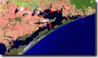
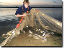
| A large research project to investigate the movement patterns of black bream throughout the Gippsland Lakes was initiated in December 2004. The research was funded by Fisheries Victoria, Land and Water Australia, the Recreational Fishing Licence Trust, and the East Gippsland Catchment Management Authority. Thirty listening stations were placed at strategic locations throughout the Gippsland Lakes, from Lakes Entrance in the east, to Lake Wellington in the west. Anglers from the Nicholson Angling Club and commercial fishers helped to catch black bream for tagging. Sixty-nine fish were tagged, with batches of fish tagged in several locations, including the Tambo and Nicholson Rivers, Holland’s Landing, Jones Bay, and Lakes Entrance. |  Listening station | |
| Most fish (59) were implanted with standard acoustic transmitters (pingers), which identify individual fish by transmitting a unique coded signal to the acoustic receivers (listening stations). Each pinger is around 20 mm long and 9 mm wide. Ten fish were implanted with advanced pingers, which are fitted with very small pressure sensors to measure water depth. Each time a pinger 'speaks' to a listening station, both the identity of the fish and the depth at which the fish is swimming is recorded. This enables scientists to determine how the depth preferences of fish change through time and among locations. | 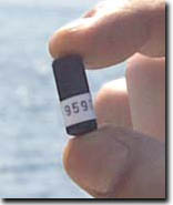 Acoustic tag |
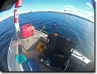 Uploading data |
The information stored in the listening stations is collected once each season. To collect the data, a diver descends to the listening station and inserts a probe into the transmission port of the receiver. The other end of the probe is attached to a computer. Data on the date and time that each fish has visited the listening station is uploaded to the computer and stored for analysis. |
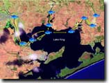
| Where, when and how far do black bream move? Results to date have provided a unique insight to the secret lives of black bream in the Gippsland lakes, and have provided a number of key findings. Black bream move throughout the Gippsland Lakes. For example, fish tagged at Holland’s Landing have been recorded at Paynesville, fish tagged in the Tambo River have been recorded at the entrance to Lake Wellington, and fish tagged at Lakes Entrance have been first detected in the Tambo River before moving to Paynesville and then back to Lakes Entrance. | 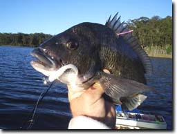 |
Whats New
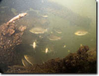
Swim with the bream. A selection of underwater video clips in the Gippsland Lakes. These clips are presented in Adobe Flash format and do not have sound.
| Track your favourite black bream Fish 1219 Fish 1248 Fish 0091 Fish 1228 | 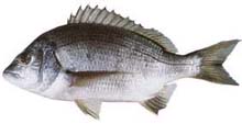 |
Bream regularly move up and down the rivers, and among the rivers. In fact, the movements are so frequent, and sometimes so large, that some fish are moving more than 3000 km in little more than a year. For example, Fish 1225 was tagged and released at the Johnsonville boat ramp on the 9th of March 2005. After release, this fish moved between the Tambo, Nicholson and Mitchell Rivers frequently, covering at least 3,200 km up until it was last detected at Swan Reach, on the Tambo River, at 4.30 am on the 28th of June 2006. | ||
Bream are capable of moving large distances quickly. For example, Fish 1219 travelled 10 km, from the entrance of the Tambo River to the southwestern edge of Raymond Island, in just over 3 hours (average speed 3 km/hr). The same fish then swam 26 km to Holland's Landing at an average speed of 1 km/hr, and, after a short rest, then swam back to Paynesville in 11 hours (average speed 2.5 km/hr), before returning to the Tambo River entrance. | ||
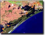
Bream do not appear to live in a single area, but may spend extended periods of time (up to months) in an area. For example, Fish 1228 moved widely between the Tambo River, Meetung and The Mitchell River, but was often recorded only around the large woody debris on the Mitchell River for periods up to 5 weeks.
 |
The large woody debris that has been re-introduced along the Tambo and Mitchell Rivers certainly provides habitat for fish of all species, not just bream. Luderick, mulloway, flathead, eels and a host of smaller species such as gobies have all been observed around these structures. For black bream, the large woody debris can be considered a type of 'road house' - while black bream regularly move up and down the rivers, individual fish may spend significant periods of time resting, seeking shelter and/or feeding in the vicinity of these structures. |  |
The patterns of the movement change among seasons, individual fish, the time of the day and the location into which fish were released. Suffice to say that movement patterns are highly dynamic, probably because of changing habitat and environmental conditions, and not all fish do the same thing.
Related Links
| Fisheries Note: | FN0583 - Movement patterns & habitat preferences of black bream in the Gippsland Lakes |
| FN0592 - Using sound advice to enhance management of Victoria's fisheries |

© State of Victoria (Agriculture Victoria) 1996 - 2025.

This work, Victorian Resources Online, is licensed under a Creative Commons Attribution 4.0 licence. You are free to re-use the work under that licence, on the condition that you credit the State of Victoria (Agriculture Victoria) as author, indicate if changes were made and comply with the other licence terms.
The licence does not apply to ‘branding’ or some ‘images or photographs’ that may be owned by third parties. We ask you to seek prior approval to use images using the VRO feedback form. Access to higher quality images can also be provided on request.
This page was last updated on 12/04/2019.