
4.2.2 Plains without leveed channels (Tragowel, Pine Grove)
4. Northern Riverine Plain (RP)
4.2 Older alluvial plains
| Plains without leveed channels are the most extensive component of the Northern Riverine Plains west of the Campaspe River. The topography is very gentle to almost level with a low northerly gradient northward towards the Murray River. Much is treeless, particularly east of the Loddon River to the Campaspe River. Like the plains with leveed channels (4.2.1) they are mainly comprised of alluvial sediments belonging to the Shepparton Formation but differ in that leveed prior stream channels are absent. They are comprised of alluvial sediments that may represent the far flood plains of the plains with leveed channels, or the alluvial plains pre-dating these. A thin layer of wind blown calcareous clay called “parna” is believed to mantle much of the prior stream plains east of the Loddon River. In the northern and western parts of the plains there are well-defined shallow drainage depressions. Plains with terminal lakes and drainage basins with lunettes (4.2.3) occur towards the most northerly extent of the plains associated with the Loddon, Avoca, Richardson and Wimmera Rivers. It is likely that most of these lakes and basins were formed as a result of past ground-water discharge from saline aquifer systems, with deflation of the dry lake beds during drier periods forming the lunettes downwind. | 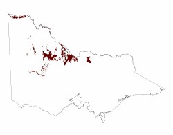 |
Around Horsham these plains mostly occur south of the Wimmera River. Prion to European settlement, woodland complexes and grasslands were the dominant vegetation types with wetlands comprising River Red Gum (Eucalyptus camaldulensis), Black Box (E. largiflorens) and Lignum (Muehlenbeckia cunninghamii) in the creek-lines and swampy areas. Grasslands dominated the plains on either side of the Avoca River and extend from just north of Charlton to north of Quambatook and most of the plains east of the Loddon River.
The dominant soils around Horsham are grey Vertosols and red and brown Sodosols and these are mostly used for cropping and pasture production. The major problems associated with the Sodosols are their hardsetting surfaces and all soils tend to have high sodicity in the deep subsoil. Further east, on the plains without leveed channels associated with the Avoca, Loddon and Campaspe catchments, the soils are mostly shallow red and brown Sodosols with occurrences of red, brown and grey Vertosols . These too have high sodicity in the deep subsoil. Most of the land is used for grazing, but there are areas under irrigation. Gilgais, a mosaic of mounds and hollows, are common features of the Vertosols prior to cultivation.

Older alluvial plain near River Murray west of Mildura,
with eroded red sodosol. Original vegetation is Bluebush
Shrubland. Background shows scarp to unit 5.1.3.
© State of Victoria (Agriculture Victoria) 1996 - .

This work, Victorian Resources Online, is licensed under a Creative Commons Attribution 4.0 licence. You are free to re-use the work under that licence, on the condition that you credit the State of Victoria (Agriculture Victoria) as author, indicate if changes were made and comply with the other licence terms.
The licence does not apply to ‘branding’ or some ‘images or photographs’ that may be owned by third parties. We ask you to seek prior approval to use images using the VRO feedback form. Access to higher quality images can also be provided on request.
This page was last updated on .