
4.2.1 Plains with leveed channels, sometimes source-bordering dunes (Tatura, Naneela)
4. Northern Riverine Plain (RP)
4.2 Older alluvial plains
| Plains with largely inactive leveed channels of various ages are a characteristic of earlier of stream deposition that predate the present flood plains. These are referred to here as the prior stream plains. They emanated from the foothills at about the same location as each of the present streams but, unlike the present streams, the stream pattern traversing the plain is distributary and/or divergent. The prior streams and associated levees are generally recognizable features on aerial photographs and contour maps, and are seen as low winding ridges up to 2 km wide and up to 3 m above the level of the surrounding flood plain. Initially the prior streams incised the sediments on the plains during prolonged wet periods, when little erosion was occurring in the uplands. During later dry periods, erosion increased in the uplands and deposited sediments within the incision. Eventually these streams filled the incision with sediment, which then spilled over the plain. Coarse material was deposited nearest to the stream channel forming levees with finer material overflowing onto the plain. In this way prior streams built up levees and clayey flood plains. Eventually the streams abandoned these courses and new courses developed in the lower land between the ridges. Stream deposition initially continued when the wetter period returned, but eventually the uplands were stabilized, and stream incision again occurred, generally outside the previous meander path. A thin layer of wind blown calcareous clay called “parna” is believed to mantle much of the prior stream plains east of the Loddon River. | 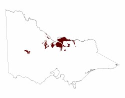 |
The most extensive area of plains with leveed channels occurs east of the Campaspe River and is associated with former courses of the Goulburn River. South and west of Rochester, there are also extensive areas of prior stream plains but these merge into plains without channels further north. Only small areas of prior stream plains associated with the Loddon River are evident and the areas associated with the Avoca River are even less evident. Plains with leveed channels occupy much of the land between Glenorchy, Murtoa and Horsham. These prior stream plains comprise a suite of sand plains, floodplains and flats including the Corkers prior stream plains, Barrabool sand plains and Wal Wal prior stream plains. To the south lies the current course of the Wimmera River while to the north, the clays plains with subdued ridges are elevated above the prior steam plains.
Prior to European Settlement the vegetation on the prior stream plains was mainly plains grassy woodland with other woodland complexes but this is mainly cleared and much is now irrigated. The little tree vegetation that remains includes Grey Box (Eucalyptus macrocarpa), Black Box (E. largiflorens) and Buloke (Allocasuarina luehmannii). In addition, Yellow Gum (E. leucoxylon) occurs around Horsham Yellow Box and (E. melliodora) on the better drained lighter textured soils around Rochester and Shepparton. The original grassland vegetation included Spear grass (Danthonia spp.) and Wallaby grass (Stipa spp.) with common rush (Juncus polyanthemus) in wetter areas.
Pasture is predominant on the more clayey soils with horticulture on the lighter textured soils, mainly around Shepparton, Tatura and Kyabram. The soils are mainly red, brown and yellow texture contrast soils (Sodosols), with grey cracking clays (Vertosols) occupying poorly drained areas. Salinity is an ever increasing problem in the irrigation districts and is associated with shallow watertables; often less than 2m deep. High sodicity in deep subsoil and soil physical properties such as a hardsetting surfaces in some Sodosols and high dry bulk densities in some Vertosols may also adversely effect yield in cropping areas.
© State of Victoria (Agriculture Victoria) 1996 - .

This work, Victorian Resources Online, is licensed under a Creative Commons Attribution 4.0 licence. You are free to re-use the work under that licence, on the condition that you credit the State of Victoria (Agriculture Victoria) as author, indicate if changes were made and comply with the other licence terms.
The licence does not apply to ‘branding’ or some ‘images or photographs’ that may be owned by third parties. We ask you to seek prior approval to use images using the VRO feedback form. Access to higher quality images can also be provided on request.
This page was last updated on .