
5.1.3 Linear dunes sub-dominant (mostly south east of Big Desert, Millewa)
5. North Western Dunefields and Plains (DP)
5.1 Calcareous dunefields
| In several parts of the Mallee the east-west dunes are small and sparse, occupying only about 5 per cent of the landscape. The largest area lies to the south of the Big Desert in a broad swathe some 30 to 50 km wide, extending from the area around Lake Hindmarsh north-easterly to Lake Tyrrell. There is a linear southerly extension on the eastern flank of the valley occupied by the Wimmera River, reaching as far as the Little Desert. The unit marks the southernmost extent of the linear dunefields. Boundaries are clear except to unit 5.1.2. There is another large occurrence in the Millewa to the south of the River Murray alluvial plains, extending in a belt some 15-30 km wide from the South Australian border to Mildura. Boundaries are clear in the north, but less so to unit 5.1.2 in the south. There is a smaller occurrence to the west of Murrayville on the uplifted Pinnaroo Block. There are also some small areas on higher ridges, for example at Walpeup and Yarrara. | 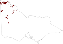 |
In the southern Mallee and to the west of Murrayville, stranded ridges are regular and prominent, averaging about 3 km from crest to crest, and occupying about 60 per cent of the landscape. The linear dunes occur mainly on the ridges.
Reddish yellow sands predominate on the dunes, with compact subsoils. The original vegetation is mostly small mallee with Spinifiex understorey.
Gilgaied clay soils (Vertosols) predominate in the southern Mallee and to the west of Murrayville on the inter-ridge plains and on lower ridge slopes. Medium-textured Calcarosols tend to occupy middle and upper ridge slopes where the native vegetation is mainly mallee. The heavier soils of the lower positions have stands of big mallee.
Pine and Belah woodlands occur widely on high ridges and in the Millewa where grasslands are also common. In these areas the soils are mostly red brown medium-textured Calcarosols, with red brown sands on the dunes.
Except in the western Millewa, the land is mostly devoted to agriculture. The erosion hazard is reduced by the lower proportion of dunes and by the widespread clay soils. However the salinity hazard is severe in the south where the rainfall is higher. Water seeps from the dunes perched on clay layers of low permeability, producing watertables beneath the swales where soluble salt contents are high. Evaporation produces saline surfaces. Reclamation involves reducing seepage with deep-rooted species on the dunes. Yields are also reduced by inherent salinity on broad clay plains, particularly on gilgai puffs. In addition, sodicity at the surface of puffs impairs tilth.
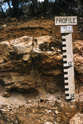 Shallow Calcarosol on Bakra Clacrete near Murrayville |
© State of Victoria (Agriculture Victoria) 1996 - .

This work, Victorian Resources Online, is licensed under a Creative Commons Attribution 4.0 licence. You are free to re-use the work under that licence, on the condition that you credit the State of Victoria (Agriculture Victoria) as author, indicate if changes were made and comply with the other licence terms.
The licence does not apply to ‘branding’ or some ‘images or photographs’ that may be owned by third parties. We ask you to seek prior approval to use images using the VRO feedback form. Access to higher quality images can also be provided on request.
This page was last updated on .