
Td1 Teesdale - Dunes
|
This information has been developed from the publications:
|
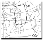
| Location | Teesdale - 426843. Former Shire of Bannockburn. Eastern side of Native Hut Creek, 4 km south of Teesdale | |
| Access | Teesdale - Inverleigh Road. | |
| Ownership | Private land. | |
Site Description | Irregular hummocky topography along the Native Hut Creek are remnants of sand dunes and sand sheets. The dunes consist of yellow grey siliceous sand derived apparently from the Moorabool Viaduct Sand during an arid phase. | |
Significance | Regional. Although sand deposits are extensive between Bannockburn and Inverleigh, most have little topographic expression. This site represents one of the few where the dunes form ridges. | |
Management | Class 2. The dunes should be retained in rural land use or public open space system. Limited sand extraction could be permitted from part of the site. | |
References | Spencer-Jones, D. (1970). | |

© State of Victoria (Agriculture Victoria) 1996 - .

This work, Victorian Resources Online, is licensed under a Creative Commons Attribution 4.0 licence. You are free to re-use the work under that licence, on the condition that you credit the State of Victoria (Agriculture Victoria) as author, indicate if changes were made and comply with the other licence terms.
The licence does not apply to ‘branding’ or some ‘images or photographs’ that may be owned by third parties. We ask you to seek prior approval to use images using the VRO feedback form. Access to higher quality images can also be provided on request.
This page was last updated on .