
K15 Kororoit Creek, St Albans - Valley Form
|
This information has been developed from the publications:
|
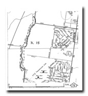
| Location | Keilor - 027205 to Sunshine - 023185. Former Cities of Keilor and Sunshine. Valley of Kororoit Creek from Main Road West (St Albans) to Peterborough Crescent (Deer Park). | 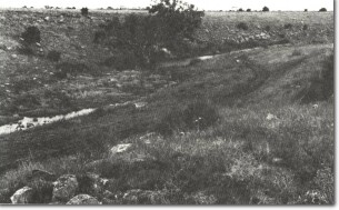 K15 - Deep pools fed by groundwater, Kororoit Creek, Ardeer. |
| Access | Main Road West and Opie Road, St Albans. | |
| Ownership | Crown land. | |
Site Description | The valley of Kororoit Creek varies from a shallow U-shaped profile to more deeply incised sectors. The number of deep permanent pools that occur indicate the recharge nature of the stream along this sector. | |
Significance | Local. The site illustrates the varied nature of the valley profile of Kororoit Creek. | |
Management | Class 2. The valley should be left with the existing profile. Land reclamation that would modify the valley profile should not be permitted. | |

© State of Victoria (Agriculture Victoria) 1996 - 2025.

This work, Victorian Resources Online, is licensed under a Creative Commons Attribution 4.0 licence. You are free to re-use the work under that licence, on the condition that you credit the State of Victoria (Agriculture Victoria) as author, indicate if changes were made and comply with the other licence terms.
The licence does not apply to ‘branding’ or some ‘images or photographs’ that may be owned by third parties. We ask you to seek prior approval to use images using the VRO feedback form. Access to higher quality images can also be provided on request.
This page was last updated on 23/11/2018.