
PPW4
Location: Werribee
Australian Soil Classification: Calcic, Subnatric, Red SODOSOL (medium to thick surface horizons)
Northcote Factual Key: Dr 2.13
Great Soil Group: red-brown earth
Previous Soil Type (Skene 1954): Werribee Loam
Map Unit (Maher and Martin, 1979) : 10b
General Landscape Description: Level plain (with prior streams).
Site Description: Grazing paddock.
Geology: Quaternary alluvial (prior stream) and aeolian deposits.
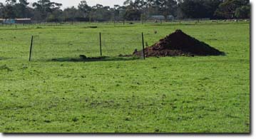 Soil Pit WP1 Landscape |
Soil Profile Morphology
| Surface Soil | 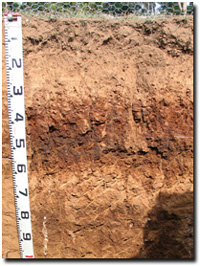 Soil Pit PPW4 Profile | ||
A1 | 0-12 cm | Brown (7.5YR4/4); fine sandy clay loam; weak coarse subangular blocky structure; very firm consistence (dry); pH 5.8; clear change to: | |
A21 | 12-20 cm | Brown (7.5YR4/6); heavy fine sandy clay loam; strong consistence (dry); macropores present; pH 6.7; clear change to: | |
A22 | 20-30cm | Brown (7.5YR4/6); heavy fine sandy clay loam; massive; strong consistence (dry); pH 7.2; abrupt change to: | |
| Subsoil | |||
B21 | 30-40 cm | Dark red (2.5YR4/8); medium clay; medium very coarse prismatic, parting to strong very coarse to coarse angular blocky structure; strong consistence (dry); few roots evident; pH 7.1; clear change to: | |
B22 | 40-60 cm | Dark red (2.5YR4/6); medium clay; medium very coarse prismatic, parting to strong coarse to medium angular, further parting to strong fine subangular blocky structure; few manganese flecks (5%); pH 7.5:; abrupt change to: | |
2B21 | 60-75 cm | Strong brown (7.5YR5/6 & 5/8); light clay (fine sandy); medium coarse blocky structure; pH 7.8: | |
2B22k | 75-100 cm | Brown (7.5YR5/4); light clay (fine sandy); few (2-5%) coarse (6-20 mm) tubular calcareous segregations with some patches of fine-earth carbonates; pH 8.3: | |
2B23 | 100-130 cm | Brown (7.5YR5/4); light clay; pH 8.2: | |
2B24 | 130-150 cm | Brown (7.5YR4/4); light medium clay; strong coarse blocky structure; pH 8.1. | |
Key Profile Features
- Strong texture contrast between surface (A) horizons and subsoil (B21) horizon.
- Buried soil horizons (of older soils) present.
Soil Profile Characteristics
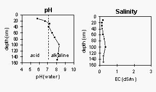
pH | Salinity Rating | |||
Surface (A1 horizon) | Moderately Acid | Very Low | Non-Sodic | None |
Subsoil (B21 horizon) | Slightly Alkaline | Very Low | Sodic | Slight-Moderate1 |
Deeper subsoil (at 130-150 cm) | Moderately Alkaline | Low | Sodic | None1 |
| 1 complete dispersion after remoulding | ||||
 |  |
Horizon | Horizon Depth (cm) | pH (water) | pH CaCl2 | EC dS/m | NaCl % | Exchangeable Cations | Ex Al mg/kg | Ex Ac meq/100g | Field pF2.5 | Wilting Point pF4.2 | Coarse Sand (0.2-2.0mm) | Fine Sand (0.02-0.2mm) | Silt (0.002-0.02mm) | Clay (<0.002mm) | |||
Ca | Mg | K | Na | ||||||||||||||
meq/100g | |||||||||||||||||
A1 | 0-12 | 5.7 | 5.5 | 0.19 | 5.1 | 3.9 | 0.39 | 0.36 | <10 | 7.1 | 33.6 | 10.5 | 19 | 36 | 19 | 16 | |
A21 | 12-20 | 6.7 | 6.3 | 0.11 | 3.5 | 2.8 | 0.12 | 0.38 | 3.7 | 27.7 | 5.4 | 16 | 43 | 21 | 16 | ||
A22 | 20-30 | 7.2 | 6.8 | 0.12 | 2.8 | 2.4 | 0.10 | 0.56 | 2.7 | 19.7 | 5.9 | 15 | 42 | 23 | 20 | ||
B21 | 30-40 | 7.1 | 6.4 | 0.15 | 5.9 | 7.4 | 0.34 | 1.6 | 7.2 | 34.7 | 18.1 | 3 | 26 | 21 | 48 | ||
B22 | 40-60 | 7.5 | 6.8 | 0.19 | 5.7 | 7.9 | 0.35 | 1.6 | 4.3 | 33.3 | 15.1 | 3 | 36 | 18 | 40 | ||
2B21 | 60-75 | 7.8 | 7.3 | 0.26 | 0.05 | 4.9 | 6.2 | 0.3 | 1.2 | 29.1 | 11.2 | 7 | 31 | 27 | 30 | ||
2B22k | 75-100 | 8.3 | 7.9 | 0.33 | 0.05 | 7.2 | 7.0 | 0.4 | 1.4 | 27.8 | 12.5 | 4 | 28 | 33 | 32 | ||
2B23 | 100-130 | 8.2 | 7.5 | 0.2 | 5.1 | 5.1 | 0.55 | 1.5 | |||||||||
2B24 | 130-150 | 8.1 | 7.4 | 0.21 | 5.3 | 6.6 | 0.39 | 1.7 | |||||||||
Management Considerations:
Whole Profile
- Management strategies for all soils should aim to increase organic matter levels in the surface soil; minimise the degradation of soil aggregates and porosity; promote the development of stable biopores; improve the calcium status of the cation exchange complex (particularly when sodium is a significant part), and break up any hardpans. Less frequent tillage; using less aggressive implements, and working the soil at optimum moisture content can all assist in maintaining soil aggregation and porosity as well as reducing the breakdown of organic matter.
- The surface horizons have high fine sand contents which makes them prone to becoming hardsetting and will result in the soil becoming ‘powdery’ when cultivated dry. Increasing organic matter levels will assist in improving surface soil aggregation and ameliorating the hardsetting condition. Organic matter levels will decline under cropping, but can be improved by adopting practices such as minimum tillage, residue retention, and utilising pasture rotations.
- The surface horizons are medium-thick in depth (i.e. 30 cm deep) – making these soils favourable for cropping.
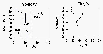
- The subsurface (A22) horizon (at 20-30 cm depth) disperses completely after remoulding. This indicates that mechanical disturbance to this horizon whilst in a moist-wet condition may result in structural degradation (e.g. development of cultivation pan).
- The upper subsoil is sodic and disperses (slight-moderate) in water. This indicates that root and water movement into the upper subsoil will be restricted. The subsoil is, however, relatively well structured for a Sodosol – in that it parts into a strong grade of medium to fine sized subangular blocky shaped peds. This would provide a more favourable structure for root movement in the upper subsoil compared to other more coarsely structured sodic subsoils.
- The subsoil disperses completely after remoulding. Care should be taken not to disturb the subsoil (e.g. by tillage) when in a moist to wet condition as structural degradation is likely to occur.
Soil profile described by Mark Imhof and Siggy Engleitner (30 April, 2004).

© State of Victoria (Agriculture Victoria) 1996 - 2025.

This work, Victorian Resources Online, is licensed under a Creative Commons Attribution 4.0 licence. You are free to re-use the work under that licence, on the condition that you credit the State of Victoria (Agriculture Victoria) as author, indicate if changes were made and comply with the other licence terms.
The licence does not apply to ‘branding’ or some ‘images or photographs’ that may be owned by third parties. We ask you to seek prior approval to use images using the VRO feedback form. Access to higher quality images can also be provided on request.
This page was last updated on 23/11/2018.