
PPW2
| Location: Leakes Road, Rockbank | |
| Aust. Soil Class.: Sodic, Eutrophic, Red Dermosol (shallow subsoil profile) | |
| General Landscape Description: Next to olive grove, on slope 650 m of summit of Mt Kororoit. | |
| Site Description: Olive roots run parallel at rock up to 100 cm out from track. | |
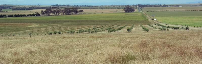 PPW1-3 Landscape |
Soil Profile Morphology:
Surface Soil
| A1 | 0-12 cm | Dark red (2.5YR4/6); fine sandy clay loam; moderate to strong coarse to medium blocky structure; pH 6.8; clear change to: | 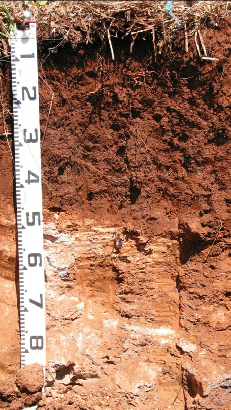 PPW2 Profile |
| Subsoil | |||
| B21 | 12-25 cm | Dark red (2.5YR4/6); medium clay; moderate very coarse, parting to medium strong prismatic, parting to strong medium blocky structure; pH 7.3; gradual change to: | |
| B22 | 25-45 cm | Dark red (2.5YR4/6); medium clay+; moderate very coarse, parting to moderate coarse prismatic, parting to strong medium blocky structure; pH 8.5: | |
| C | 45-100 cm | Small hunks of very fine scoria (50-150 mm) embedded in weathering carbonate layers (i.e. patches); weathering scoria with large patch of carbonate (20%). | |
Key Profile Features:
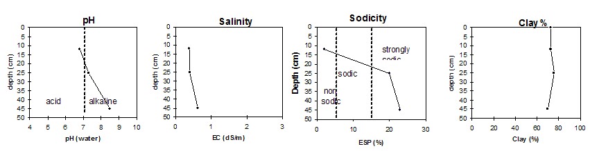
Soil Profile Characteristics:
pH | Salinity Rating | |||
Surface (A1 horizon) | Slightly Acid | Non-Sodic | ||
Subsoil (B21 horizon) | Slightly Alkaline | Strongly Sodic | ||
Deeper subsoil (at 25-45 cm) | Moderately Alkaline | Strongly Sodic |
 |
Horizon | Horizon Depth | pH (water) | pH CaCl2 | EC 1:5 | NaCl | Exchangeable Cations | |||
Ca | Mg | K | Na | ||||||
Meq/100g | |||||||||
A1 | 0-12 | 6.7 | 6.7 | 0.7 | <0.01 | 18 | 8.7 | 1.4 | 0.6 |
B21 | 12-25 | 7.3 | 6.7 | 0.41 | 0.02 | 8.4 | 13 | 2.5 | 5.7 |
B22 | 25-45 | 8.5 | 7.9 | 0.64 | 0.03 | 9.8 | 21 | 2.4 | 9.5 |
Horizon | Horizon Depth | Ex Al mg/kg | Ex Ac meq/100g | Field pF2.5 g/100g | Wilting Point pF4.2 g/100g | Coarse Sand (0.2-2.0mm) % | Fine Sand (0.02-0.2mm) % | Silt (0.002-0.02mm) % | Clay (<0.002mm) % |
A1 | 0-12 | 17 | 27.5 | 37.9 | 5 | 10 | 5 | 73 | |
B21 | 12-25 | 31.5 | 45.3 | 4 | 9 | 5 | 76 | ||
B22 | 25-45 | 34 | 54.4 | 4 | 10 | 10 | 70 |

© State of Victoria (Agriculture Victoria) 1996 - 2025.

This work, Victorian Resources Online, is licensed under a Creative Commons Attribution 4.0 licence. You are free to re-use the work under that licence, on the condition that you credit the State of Victoria (Agriculture Victoria) as author, indicate if changes were made and comply with the other licence terms.
The licence does not apply to ‘branding’ or some ‘images or photographs’ that may be owned by third parties. We ask you to seek prior approval to use images using the VRO feedback form. Access to higher quality images can also be provided on request.
This page was last updated on 23/11/2018.