
GP82
| Location: Labertouche | Aust. Soil Class.: Magnesic, Mottled-Hypernatric, Grey SODOSOL |
| General Landscape Description: Level plain (Tynong unit of Westernport survey) | Geology: Quaternary alluvium (late Pleistocene) |
Soil Profile Morphology:
Surface Soil
| A1 | 0-15 cm | Black (10YR 2/1), light sandy clay loam (organic); weak coarse blocky structure, moist consistence (weak); organic mat at 4 cm; pH 4.8; abrupt and way change to: | 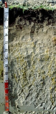 GP82 Profile |
| A21 | 15-35 cm | Brown (10YR 5/3); sandy loam; weak to firm consistence (moist); pH 4.9; gradual change to: | |
| A22 & Bhs | 35-60 cm | Light grey (10YR 7/2) with few yellow (10YR 7/6) mottles; light sandy clay loam; weak to firm consistence (moist); pH 7.0; discontinuous "coffee rock" layer; wavy and clear change to: | |
| Subsoil | |||
| B21 | 60-80 cm | Light grey (10YR 7/2) and light brownish grey (10YR 6/2) with yellow (10YR 7/8) and reddish yellow (7.5YR 6/8) mottles; medium clay with grit; moderate coarse blocky structure; very firm consistence (moist); quartz fragments (20%) with some feldspar; pH 7.7; gradual change to: | |
| B22 | 80-120 cm | ight brownish grey (10YR 6/2) with reddish yellow (7.5YR 6/8) mottles; light medium clay with grit; moderate very coarse blocky parting to moderate coarse blocky structure, felspar (10%) 2-5 mm fragments; pH 7.8: | |
| B23 | 120+ cm | Light brownish grey (10YR 6/2); light medium clay with grit; pH 7.5. | |
Key Profile Features:
Soil Profile Characteristics:
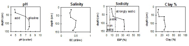
pH | Salinity Rating | |||
Surface (A1 horizon) | Very Strongly Acid | Medium | Non-Sodic | None |
Subsoil (B21 horizon) | Slightly Alkaline | Medium-High | Strongly Sodic | None1 |
Deeper subsoil (at 1.2 m) | Slightly Alkaline | Medium - High | Strongly Sodic | None1 |
Horizon | Horizon Depth | pH (water) | pH CaCl2 | EC 1:5 | NaCl | Exchangeable Cations | |||
Ca | Mg | K | Na | ||||||
Meq/100g | |||||||||
A1 | 0-15 | 4.8 | 4.1 | 0.35 | 0.07 | 4.0 | 1.1 | 0.2 | 0.5 |
A21 | 15-35 | 4.9 | 4.5 | 0.31 | 0.07 | 0.6 | 0.2 | <0.1 | <0.1 |
A22 | 35-60 | 7.0 | 6.4 | 0.33 | 0.07 | 0.5 | 0.9 | <0.1 | 0.2 |
B21 | 60-80 | 7.7 | 7.1 | 0.51 | 0.12 | 0.8 | 3.7 | 0.3 | 2.2 |
B22 | 80-120 | 7.8 | 7.1 | 0.48 | 0.11 | 0.6 | 4.4 | 0.2 | 2.5 |
B23 | 120+ | 7.5 | 6.9 | 0.41 | 0.10 | 0.4 | 3.3 | 0.2 | 1.9 |
Horizon | Horizon Depth | Ex Al mg/kg | Ex Ac meq/100g | Field pF 2.5 | Wilting Point pF4.2 g/100g | Coarse Sand (0.2-2.0mm) % | Fine Sand (0.02-0.2mm) % | Silt (0.002-0.02mm) % | Clay (<0.002mm) % |
A1 | 0-15 | 39 | 17 | 31.7 | 10.3 | 31.9 | 29.2 | 19.0 | 8.0 |
A21 | 15-35 | 12 | 2.0 | 15.4 | 2.3 | 37.8 | 32.5 | 21.5 | 6.0 |
A22 | 35-60 | 13.5 | 1.0 | 33.6 | 34.5 | 21.0 | 10.0 | ||
B21 | 60-80 | 21.4 | 10.3 | 30.4 | 23.0 | 17.0 | 28.0 | ||
B22 | 80-120 | 25.8 | 19.5 | 29.0 | 20.4 | 16.5 | 32.0 | ||
B23 | 120+ | 28.3 | 23.2 | 18.0 | 28.0 |
Management Considerations:
Subsoil (B) Horizons
- Very low exchangeable calcium:magnesium ratio (i.e. <0.2). This may result in nutrient imbalances (e.g. calcium deficiency).

© State of Victoria (Agriculture Victoria) 1996 - 2025.

This work, Victorian Resources Online, is licensed under a Creative Commons Attribution 4.0 licence. You are free to re-use the work under that licence, on the condition that you credit the State of Victoria (Agriculture Victoria) as author, indicate if changes were made and comply with the other licence terms.
The licence does not apply to ‘branding’ or some ‘images or photographs’ that may be owned by third parties. We ask you to seek prior approval to use images using the VRO feedback form. Access to higher quality images can also be provided on request.
This page was last updated on 23/11/2018.