
Local Government
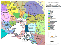
| The Local Government Areas map is intended to broadly show the relative areas and boundaries of each council located within and outside the region. Data to create this map is derived from the Local Government Area layer (L100) of the Department of Primary Industries Corporate Geospatial Data Library. This layer describes the post amalgamation LGA boundaries as defined by the Department of Finance. Place names (ie: towns) are provided by Vicroads and AUSLIG. |
The following Local Government Authorities websites have offices within and outside the Port Phillip and Westernport Catchment Management Region:

© State of Victoria (Agriculture Victoria) 1996 - 2025.

This work, Victorian Resources Online, is licensed under a Creative Commons Attribution 4.0 licence. You are free to re-use the work under that licence, on the condition that you credit the State of Victoria (Agriculture Victoria) as author, indicate if changes were made and comply with the other licence terms.
The licence does not apply to ‘branding’ or some ‘images or photographs’ that may be owned by third parties. We ask you to seek prior approval to use images using the VRO feedback form. Access to higher quality images can also be provided on request.
This page was last updated on 23/11/2018.