
L15 - Bacchus Marsh - Maddingley Coal Seam
|
This information has been developed from this publication:
|
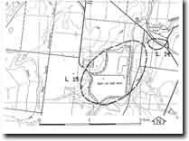
| Location: | Lerderderg - 745232. Shire of Bacchus Marsh. 3 km south of Bacchus Marsh. | 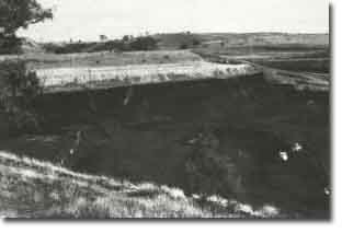 Bacchus Marsh - Maddingley Coal Seam |
Access: | South Maddingley Road. | |
Ownership: | Private land | |
Site Description: | The Maddingley No. 2 open cut is the only brown coal mine currently operating in the Bacchus Marsh district. It extracts coal from a seam averaging 30 m thick under only 10 m of overburden in an area free from overlying lava flows. The lavas have been eroded by the Parwan Creek, and the mining company has diverted the creek to the east in an artificial channel to allow access to the coal seam. The coal is of lesser grade than the La Trobe valley coal but is suitable as an industrial fuel. The coal is of Early Miocene age, and overlies and is interbedded with the Werribee Formation. The seams are probably laterally continuous with those known sub-surface at Altona. There are abundant plant remains in the coal including woody material and large trees. Part of one large tree trunk was successfully made into paper by a private research laboratory. | |
Significance: | State. The coal seams are the third largest known in Victoria (after the La Trobe valley area and Anglesea deposits). They are a readily recognisable geological material and provide clear evidence of a terrestrial depositional environment. There is abundant plant material to allow detailed reconstruction of the species composition of the swamp forest communities that gave rise to the coal deposits. This open cut provides a clear section view of the geological relationships of the coal to the overlying sediments. | |
Management: | Class 2. A section of the open cut (preferably with abundant visible plant material) should be reserved for education purposes, and a safe access and viewing platform provided. | |
The economic geology and stratigraphy of the coalified and a detailed reference list is provided in Roberts PS (1984). | ||
 Site - L15 |

© State of Victoria (Agriculture Victoria) 1996 - .

This work, Victorian Resources Online, is licensed under a Creative Commons Attribution 4.0 licence. You are free to re-use the work under that licence, on the condition that you credit the State of Victoria (Agriculture Victoria) as author, indicate if changes were made and comply with the other licence terms.
The licence does not apply to ‘branding’ or some ‘images or photographs’ that may be owned by third parties. We ask you to seek prior approval to use images using the VRO feedback form. Access to higher quality images can also be provided on request.
This page was last updated on .