L13 - Parwan - Lava Cave
|
This information has been developed from this publication:
|
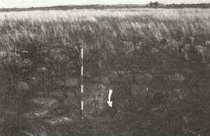
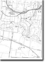
| Location: | Lerderderg - 777227. Shire of Bacchus Marsh. East of Parwan South Road, 1 km southeast of Parwan railway station. |  Parwan - Lava Cave |
Access: | Parwan South Road. | |
Ownership: | Private land. | |
Site Description: | Lava tubes form when the outer surface of a lava flow cools and solidifies to a hard crust surrounding a still liquid interior. This interior may drain through a breach in the solid crust, leaving an elongated hollow interior or lava tunnel. If part of the crust collapses into the tunnel, entrance may be gained to the lava cave. | |
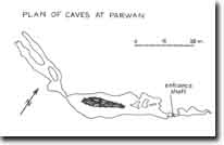
The Parwan cave is a passage aligned roughly east-west, the floor of the cave averaging 8 to 10 m below the level of the land surface. There is a single entrance 1.5 m wide that descends 3 m to the floor of the cave. The roof of the main passages averages 2 m high and allows easy movement through the cave. The cave walls and roof are rough and uneven and there are numerous fallen blocks. From the entrance, a narrow but clear passage extends northeast for 40 m before becoming impassable and a narrow rock encumbered tube gives access to the larger and longer western chambers. The first of these is 70 m long and 20 m wide and is divided longitudinally by a massive rock fall. At the western end of this is a squeeze leading to a second chamber over 80 m long divided into two passages which narrow and become impassable. Beyond this the caves continue but are not accessible. | ||
An ephemeral stream channel occurs on the south side of the cave for 20 to 40 m either side of the entrance. | ||
Included in the earth materials of the cave floor are hummocks and mounds of phosphate concentrations derived from bat droppings. In these, a previously undescribed magnesium aluminium phosphate mineral (parwanite) has been recognised. | ||
Significance: | State. There are few lava caves in Victoria and the Parwan cave is the only one known on the Werribee Plains. It is the closest known cave to the Melbourne metropolitan area, is a relatively large cave and is important for the occurrence of the newly described mineral. The presence of the phosphates indicates the cave was recently used by bats but it has been abandoned for the last 100 years. | |
Management: | Class 1. The cave is a robust feature and contains no delicate or sensitive decorations. It is easy of access, safe, and provides a good site to serve as an introduction to simple caving techniques. The parwanite on the cave floor appears to be abundant and not threatened by normal caving activities. The main deterioration of cave quality is the appearance of graffiti on some of the cave walls. | |
A management problem is posed by the fact that the cave is located in a farm paddock which is used for grazing. Although many groups approach the owner for permission to enter the property (which is readily given), there is an on-going problem of unauthorized and irresponsible entry and use of the site. In the event of a less co-operative landowner assuming control of the property, it may be necessary for the Shire to enter into an agreement regarding times and conditions of access. | ||
In the event of a re-zoning of land use, the site should revert to public ownership. No drilling, road works, excavations or buildings should be permitted over the area of the cave. | ||
References: | Rees DJ and Gill ED (1958) Webb JA et al (in press) | |
 Site - L13 |


