
Public Land
Approximately 13% of the catchment region is public land and much of this has been nominated for specific purposes, such as National, State and Regional Parks, scientific/education areas and Flora Reserves. About 10% of these public lands are managed by the Department of Sustainability and Environment (DSE) through licence issuing , are recognised as being multiple-use areas suitable for:
- timber utilisation
- grazing
- eucalyptus harvesting for oil production
- water production
- recreation
- honey production
Crown Land Management (external link) (within the Land Victoria Division of DSE) has a number of roles and responsibilities with respect to the management of public land within the North Central region, including:
- Acts on behalf of the Victorian Government as the agent for the Crown Land outside of the parks and forests systems, the majority occupied by individuals and organisations/clubs other than the Department of Sustainability and Environment;
- Purchases, exchanges, sells, reserves and leases or licences land and property for DSE and other parts of Government;
- Provides policy and a regulatory framework for the reservation, management and use of Crown Land;
- Facilitates major Government and private infrastructure projects through the commercial leasing, reservation and delegated management of Crown Land;
- Maintains the Crown land data base covering relevant Crown allotments;
- For the purposes of Native Title claims, researches and determines the tenure history of Crown Land under claim and provides DSE policy input to the Government’s response to Native Title;
- Coordinates responses to land use planning proposals on behalf of DSE;
- Acts as a referral authority for proposed developments on private and Crown Land;
- Provides new information technology developments and initiatives to support cadastral and natural resource decision-making and program delivery.
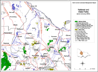
This map shows the location of State and National Parks in the North Central region, and in nearby regions (as at January 2004). Parks Victoria manages Victoria's world class network of national, state, regional and metropolitan parks, other conservation reserves, many significant cultural assets, and Melbourne's bays and major waterways. The Parks Victoria Parkweb website (external link) provides information about each of Victoria's National and State Parks. |
Actual management of land use activities on Crown land has been undertaken by Parks Victoria (external link) since December 1996. Its main purpose with respect to Crown land use is to conserve, protect and enhance environmental and cultural assets throughout the North Central catchment region.
© State of Victoria (Agriculture Victoria) 1996 - 2025.

This work, Victorian Resources Online, is licensed under a Creative Commons Attribution 4.0 licence. You are free to re-use the work under that licence, on the condition that you credit the State of Victoria (Agriculture Victoria) as author, indicate if changes were made and comply with the other licence terms.
The licence does not apply to ‘branding’ or some ‘images or photographs’ that may be owned by third parties. We ask you to seek prior approval to use images using the VRO feedback form. Access to higher quality images can also be provided on request.
This page was last updated on 23/03/2020.