Gooches Hill
|
This information has been obtained from the report: Eruption Points of the Newer Volcanic Province of Victoria by Neville Rosengren. This report was published in 1994 and was prepared for the National Trust of Australia (Victoria) and the Geological Society of Australia (Victorian Division). The review of eruption points was based on an earlier unpublished manuscript Catalogue of the post-Miocene volcanoes of Victoria compiled by O P Singleton and E B Joyce (Geology Department, University of Melbourne 1970). |
| Kangaroo Hill, Widdicombes Hill. |  Gooches Hill | |
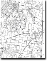
37 18 32S 144 13 15E (external link); 723-3-1 (Daylesford) 535672. 6 km NE of Daylesford. | ||
Glenlyon Road. | ||
Daylesford and Glenlyon. | ||
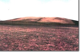
Private land. Cropping and grazing, three mounds, no outcrop. | ||
Type 9: | Composite scoria cones overlying lava flows. | |
This is a complex and possibly multiple eruption point. There are three mounds of scoria around a shallow crater form open to the east. Extensive flows of lava issued from this point before the building of the scoria cone. The lava extended north burying the Daylesford-Glenlyon lead on the ancestral Loddon River. This flow has now been dissected by the Loddon and the lava occurs as discontinuous plateau residuals. | ||
660+ m; 75 m. | ||
Regional: | This is an example of a complex eruption point and is also significant as the source of a major lava flow influencing the geomorphology of a large area of the Central Highlands. | |
| References: | Coulson, A. (1954). The volcanic rocks of the Daylesford district. Proceedings of the Royal Society of Victoria 65, pp. 113-124. | |
 Gooches Hill 7723-3-1 (DAYLESFORD) |


