
Elevation
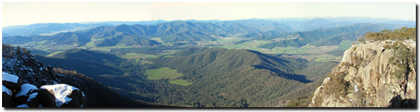 View from Mount Buffalo. |
Mount Bogong (1 986 m above sea level) is the highest peak in the Victorian alpine region. It is surrounded by several other peaks above 1 500 m, including Mt Feathertop (1 922 m), Mt Hotham (1 862 m) and Mt Buffalo (1 723 m). Just south of Mt Bogong are the Bogong High Plains and further south again lie the Dargo High Plains and Snowy Range. The highest peaks all rest in the southern part of the region. As elevation declines, gradually hill slopes develop. Moving further north towards the Murray River eventually the landscape grades into undulating plains. There are, however, exceptions to this trend, where Mt Burrowa (1 278 m) is accompanied by Mt Mitta Mitta (1 001 m) and Pine Mountain in the northern most section of the region, east of Lake Hume (Duncan, 1982).
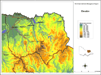 North East Elevation |
|
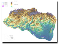 North East 3D Elevation Overview |
|
© State of Victoria (Agriculture Victoria) 1996 - 2025.

This work, Victorian Resources Online, is licensed under a Creative Commons Attribution 4.0 licence. You are free to re-use the work under that licence, on the condition that you credit the State of Victoria (Agriculture Victoria) as author, indicate if changes were made and comply with the other licence terms.
The licence does not apply to ‘branding’ or some ‘images or photographs’ that may be owned by third parties. We ask you to seek prior approval to use images using the VRO feedback form. Access to higher quality images can also be provided on request.
This page was last updated on 25/01/2019.