
MP2
| Location: Tiega | Australian Soil Classification: Hypercalcic, Subnatric, Red SODOSOL |
| Northcote Factual Key: Dr 2.13 | Great Soil Group: no suitable group |
| General Landscape Description: Large (almost closed) depression lying in between a ridge to the west and a lunette to the east. | |
| Geology: Quaternary Woorinen Formation (possibly a few metres deep) deposits, overlying lacustrine deposits. | |
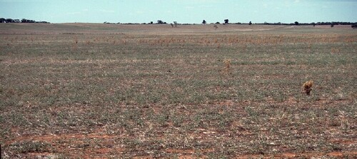 MP2 Landscape |
Soil Profile Morphology:
Surface Soil
| A11 | 0-12 cm | Yellowish red (5YR4/6); sandy loam; hardsetting surface condition; massive in structure with plough pan formations; firm consistence dry; contains a common (10%) amount of coarse fragments (6-20 cm in size); slightly calcareous; pH 7.8; sharp and smooth change to: | 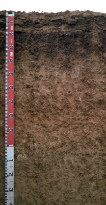 MP2 profile |
| A12 | 12-15 cm | Sandy loam; very firm consistence dry; sharp change to: | |
| Subsoil | |||
| B21 | 15-30 cm | Yellowish red (5YR4/5); medium clay; moderate medium-coarse blocky, breaking down to strong medium blocky structure; strong consistence dry; slightly calcareous; pH 8.5; clear and wavy change to: | |
| B22k | 30-80 cm | Strong brown (7.5YR4/6); light medium clay; moderate medium blocky structure; strong consistence dry; contains a common (20 - 30%) amount of soft carbonate; very highly calcareous; pH 9.4; diffuse change to: | |
| B23 | 80-100 cm | Yellowish brown (10YR5/6); medium heavy clay; moderate medium prismatic structure; strong consistence dry; contains very few (<2%) soft carbonates and manganiferous material; highly calcareous; pH 9.1; gradual change to: | |
| B24 | 100+ cm | Yellowish brown (10YR5/6); medium heavy clay; moderate coarse prismatic, breaking down to coarse blocky structure; strong consistence dry; contains very few (<2%) soft carbonates and a few (2-5%) fine gypsum crystals; moderately calcareous; pH 9.0. | |
Key Profile Features:
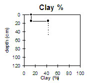
- Strong texture contrast between surface (A) horizons (13% clay) and sodic subsoil (B21) horizon (44% clay). ie. Sodosol.
- Accumulation of carbonates in B horizon. ie. hypercalcic.
- High fine sand and hardsetting surface condition.
- Subsoil becomes strongly sodic at 20 cm.
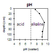 | 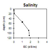 |
| The surface soil is slightly alkaline. The subsoil is moderately alkaline becoming very strongly alkaline with depth. | The salinity rating is low in the surface soil and upper subsoil. However, the deeper subsoil has quite a high rating. |
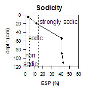 |  |
| The surface soil is non-sodic. The upper subsoil is sodic becom-ing strongly sodic at 20 cm depth. | The surface soil is non-sodic. The upper subsoil is sodic becom-ing strongly sodic at 20 cm depth. |
Management Considerations:
Surface (A) Horizons
- The surface soil has a very high fine sand content (65%) and is hardsetting when dry. When cultivated in a dry condition it will become ‘powdery’ and subsequent rainfall may result in surface sealing occurring. The levels of organic carbon measured at the pit site is low (this may or may not be representative of the whole paddock). Organic matter levels will decline if cropping takes place and can be improved by adopting practices such as residue retention, minimum tillage and utilising pasture rotations. Increased organic matter will both improve aggregation as well as assist in the low water holding capacity and low inherent fertility of this surface soil.
- The levels of total nitrogen measured at this pit site is low. However, this is best assessed by taking a bulked sample from across the paddock.
- Infiltration of water is likely to be high in the surface horizons and the second surface horizon (A12) may become ‘soupy’ as water sites in the less permeable subsoil. Deep ripping would allow this water to enter the subsoil and thus not be lost to evaporation.
Subsoil (B) Horizons
- The salinity rating becomes moderate at about 35 cm depth and increases to a high level at about 50 cm. These levels of soluble salts are likely to restrict the growth of salt sensitive plant species (e.g. faba beans, linseed, chickpeas and lupins).
- The coarsely structured subsoil below 20 cm depth becomes strongly sodic and has a low exchangeable calcium to magnesium ratio (ie. <1). Dispersion occurs as a result restricting root and water movement, however, with the increase of salinity levels going down the profile the dispersion decreases accordingly. Deep ripping into the subsoil would help to break up the physical structural problems and the application of gypsum would help to neutralise the chemical sodic problems. This expensive option would firstly depend on expected crop yield and also on adequate rainfall, to wash the gypsum down the deep rips into the subsoil. Gypsum can also be added to the surface without deep ripping, but it would require more time to wash the gypsum down to the subsoil and less of it would probably make it
- The subsoil has a moderate inherent fertility throughout, as well a high accumulation of calcium which would both aid soil structure and plant growth.
- The strongly alkaline subsoil suggests that some nutrients (e.g. manganese, zinc, iron, copper) may be poorly available to plants.
- The high level of exchangeable sodium and magnesium in the deeper subsoil may also result in nutrient imbalances and may also have a toxic effect on some plants.
- The high clay texture means that there is a large store of water in the subsoil for root growth however, the chemical and physical problems makes it largely unattainable.
Profile Described By: Profile described by Mark Imhof, Paul Rampant and Sonia Thompson (March 1994).
© State of Victoria (Agriculture Victoria) 1996 - 2025.

This work, Victorian Resources Online, is licensed under a Creative Commons Attribution 4.0 licence. You are free to re-use the work under that licence, on the condition that you credit the State of Victoria (Agriculture Victoria) as author, indicate if changes were made and comply with the other licence terms.
The licence does not apply to ‘branding’ or some ‘images or photographs’ that may be owned by third parties. We ask you to seek prior approval to use images using the VRO feedback form. Access to higher quality images can also be provided on request.
This page was last updated on 23/03/2020.