
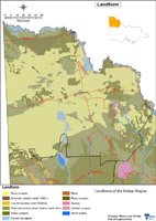
Landform
 |
|
|
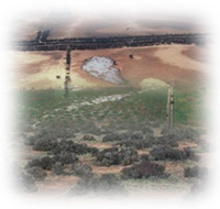
The Mallee region consists of a vast plain where there are superficial undulations. Elevations vary in the south of the region from 100 to 120 metres above sea level, falling to between 50 to 70 metres in the centre and north. The major drainage pattern is the Murray River system along the northern boundary. There are occasional creeks such as the Tyrell, Lambert, Yarriambiack and Outlet Creeks that are usually dry. They terminate in the central part of the region in basins containing salt and gypsum. Four main landforms have been recognised in the region: dunes, jumbled dunes, ridges and hummocks. Other landforms such as lunettes and copi islands occur to a more limited extent. These superficial undulations are all of aeolian origin. Source: Rowan and Downes (1963). |
Geology Information
Geoscience Victoria's web mapping application allows users to search geospatial databases and display the results as maps or tables. Datasets that can be viewed and interrogated include mineral, petroleum and extractive industries tenements, land-use and airborne geophysical survey boundaries, gravity, magnetic and radiometric images, bore hole & well data, surface geochemistry results, mines and mineral occurrences, and geological maps and interpretations at various scales.
© State of Victoria (Agriculture Victoria) 1996 - 2025.

This work, Victorian Resources Online, is licensed under a Creative Commons Attribution 4.0 licence. You are free to re-use the work under that licence, on the condition that you credit the State of Victoria (Agriculture Victoria) as author, indicate if changes were made and comply with the other licence terms.
The licence does not apply to ‘branding’ or some ‘images or photographs’ that may be owned by third parties. We ask you to seek prior approval to use images using the VRO feedback form. Access to higher quality images can also be provided on request.
This page was last updated on 23/03/2020.