
MP49
| Location: Murrayville Landcare Group. | Australian Soil Classification: Epibasic, Petrocalcic, Lithocalcic, CALCAROSOL |
| General Landscape Description: Low rise on a gently undulating plain. | Geology: Quaternary (Woorinen Formation) deposits. |
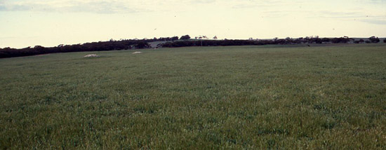
MP49 Landscape
Soil Profile Morphology:
Surface Soil
| A11 | 0-10 cm | Dark greyish brown (7.5YR3/4); sandy loam; non-calcareous; pH 7.8: | 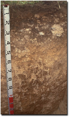 MP49 Profile |
| A12 | 10-20 cm | Reddish brown (5YR5/8); sandy clay loam; very firm consistence dry; contains many (40%) soft calcareous segregations and calcrete fragments formed insitu; moderately calcareous; pH 8.2: | |
| Subsoil | |||
| C | 20-45 cm | Calcrete Layer: | |
| 2B21 | 45-70 cm | Lightish red-brown (2.5YR5/8); light clay (fine sandy); contains many (50%) soft calcareous segregations with calcrete fragments are common (20%); highly calcareous; many macropores; pH 9.6: | |
| 2B22 | 70-100 cm | Light medium clay (sandy); soft calcareous segregations are common (20%); highly calcareous; pH 9.8: | |
| 2B23 | 100+ cm | Medium clay (fine sandy); contains a few (2-5%) soft manganiferous segregations; moderately calcareous; pH 9.4. | |
Key Profile Features:
- Medium depth of surface soil overlying calcrete.
- Presence of thick calcrete layer below surface soil.
pH | Salinity Rating | |||
Surface (A11 horizon) | Slightly alkaline | Low | Non-sodic | None |
Sub-surface (A12 horizon) | Moderately alkaline | Low | Non-sodic | None1 |
Deeper Subsoil (at 0.45 m) | Very strongly alkaline | Very high | Sodic | None2 |
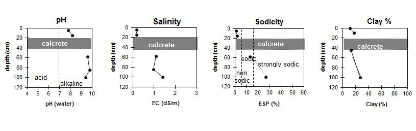
| The soil profile becomes increasingly alkaline with depth. | The level of soluble salts increases with depth. | The soil profile becomes increasingly sodic with depth. | The clay content gradually increases with depth. |
Horizon | Horizon Depth (cm) | pH (water) | pH (CaCl2) | EC 1:5 | NaCl % | Total Nitrogen % | Organic Carbon % | Exchangeable Cations | |||
Ca | Mg | K | Na | ||||||||
meq/100g | |||||||||||
A11 | 0-10 | 7.8 | 7.1 | 0.19 | 0.12 | 1.5 | 6.5 | 2.1 | 1.4 | 0.09 | |
A12 | 10-20 | 8.2 | 7.6 | 0.17 | 11 | 3.5 | 1 | 0.19 | |||
2B21 | 45-70 | 9.6 | 8.9 | 1.1 | 0.2 | 5.6 | 8.3 | 0.7 | 2.1 | ||
2B22 | 70-100 | 9.8 | 9 | 0.97 | 0.18 | ||||||
2B23 | 100+ | 9.4 | 8.6 | 1.4 | 0.28 | 1.1 | 11 | 1.8 | 5.1 | ||
Horizon | Horizon Depth (cm) | Exchangeable Aluminium mg/kg | Exchangeable Acidity meq/100g | Field Capacity pF2.5 | Wilting Point pF4.2 | Coarse Sand (0.2-2.0 mm) | Fine Sand (0.02-0.2 mm) | Silt (0.002-0.02 mm) | Clay (<0.002 mm) |
A11 | 0-10 | 11 | 5 | 39 | 45 | 4 | 12 | ||
A12 | 10-20 | 14 | 6 | 34 | 42 | 5 | 18 | ||
2B21 | 45-70 | <5 | 20 | 28 | 7 | 13 | |||
2B22 | 70-100 | - | |||||||
2B23 | 100+ | <5 | 20 | 38 | 13 | 27 |
Management Considerations:
Whole Profile
- In general, management strategies for all soils should aim to: increase organic matter levels in the surface soil, minimise the degradation of soil aggregates and porosity, promote the development of stable biopores, break up any hardpans, and improve the calcium status of the ion exchange complex. Particularly when sodium plays a significant part i.e. the soil is sodic. Less frequent tillage, using less aggressive implements, and working the soil at optimum moisture conditions can all assist in maintaining soil aggregation and porosity, as well as reducing the breakdown of organic matter.
- The soil profile will be well drained. Water is likely to move rapidly through the fractured calcrete layer.
- Plant available water capacity will be restricted by the shallow depth of soil above the calcrete layer.
- The subsurface (A12) horizon disperses moderately after remoulding. Disturbance to this horizon by tillage when in a moist to wet condition, may result in some structural degradation.
Subsoil (B) Horizons
- The calcrete layer will restrict root and water movement.
- The soil below the calcrete layer is also likely to restrict plant root growth. It is sodic, has a very high level of soluble salts and is very strongly alkaline.
Profile Described By: Mark Imhof (August 1999).
© State of Victoria (Agriculture Victoria) 1996 - 2025.

This work, Victorian Resources Online, is licensed under a Creative Commons Attribution 4.0 licence. You are free to re-use the work under that licence, on the condition that you credit the State of Victoria (Agriculture Victoria) as author, indicate if changes were made and comply with the other licence terms.
The licence does not apply to ‘branding’ or some ‘images or photographs’ that may be owned by third parties. We ask you to seek prior approval to use images using the VRO feedback form. Access to higher quality images can also be provided on request.
This page was last updated on 23/03/2020.