Sodosols
Sodosols have a strong texture contrast between loamy surface (A) horizons and clayey subsurface (B) horizons. The subsoils are sodic (i.e. exchangeable sodium percentage (ESP) is 6 or greater) and are not strongly acid (i.e. pH 5.5 or greater).
Sodosols can be separated on the basis of the colour of the upper 20 cm of the subsoil into Red, Brown, Yellow, Grey and Black groups. In the Mallee region, Red Sodosols are the most common.
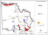
| Sodosols in the Mallee Region. This map of Sodosols in the Mallee region has been developed by Jim Rowan and is based on the Land Systems of Victoria (1:250 000). It shows areas where Sodosols are most likely to occur within the region and should only be used as a general indication of their distribution. Please note that other soil types may also occur within these mapped areas. Sodosols may occur in areas not mapped here, however, these are most likely to be minor occurrences. |
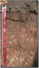
 A Sodosol near Speed. Note: the lighter textured sandy loam surface soil overlying the sodic clay subsoil at 10 cm depth. | Red Sodosols (with loamy surface horizons) abruptly overlying red sodic clays, occur on older alluvial terraces. They have been capped with clayey aeolian sediments. In the southern Mallee, Sodosols are found near creeks and rivers, often where the original vegetation of grassy Casuarina woodlands contrasts with the surrounding Mallee scrub. Erosion has frequently removed the surface (A) horizons to expose red, somewhat saline clays, that seal over on wetting. These sites are difficult to reclaim on dryland farms and are known as "scalded country". On the higher terraces in the north near the River Murray, Sodosols support shrublands of saltbush and bluebush that are characteristic of the arid interior. Scalding is a problem here also. Red Sodosols can also occur on lunettes in the Tyrell basin. These do not show up on the map provided here, as they are too difficult to map at this broad scale. |


