
Hydrosols
Hydrosols are soils which are seasonally or permanently saturated (for at least 2-3 months per year).
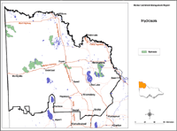
| Hydrosols in the Mallee Region This map of Hydrosols in the Mallee region has been developed by Jim Rowan and is based on the Land Systems of Victoria (1:250 000). It shows areas where Hydrosols are most likely to occur within the region and should only be used as a general indication of their distribution. Please note that other soil types may also occur within these mapped areas. Hydrosols may occur in areas not mapped here, however, these are most likely to be minor occurrences. |
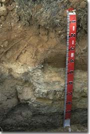 A Hydrosol near Ouyen. Note gypsum crystals in the 45-75 cm zone. |
Hydrosols occur naturally in low-lying parts of the central and northern Mallee region where saline regional groundwater reaches the surface. Soil surfaces are variably saline, depending largely on depth to the watertable. Soils which are saline to the surface are commonly red clay loams overlying gypsum. They may be bare or support extremely salt tolerant low bushes such as samphire. Soils which are non-saline at the surface but highly saline at depth, usually have a sandy surface and support shrubs such as saltbush. The area of Hydrosols is increasing in both dryland and irrigated areas because of changed hydrological conditions since European settlement. |
© State of Victoria (Agriculture Victoria) 1996 - 2025.

This work, Victorian Resources Online, is licensed under a Creative Commons Attribution 4.0 licence. You are free to re-use the work under that licence, on the condition that you credit the State of Victoria (Agriculture Victoria) as author, indicate if changes were made and comply with the other licence terms.
The licence does not apply to ‘branding’ or some ‘images or photographs’ that may be owned by third parties. We ask you to seek prior approval to use images using the VRO feedback form. Access to higher quality images can also be provided on request.
This page was last updated on 23/03/2020.