
MP34
| Location: Nullawil. | Australian Soil Classification: Endocalcareous-Endohypersodic, Epipedal, Brown VERTOSOL. |
| Geology: Recent alluvial deposits (Coonambidgal Formation). | |
| General Landscape Description: Alluvial plain - original vegetation included Black Box (E. largiflorens) and Lignum Bush (Muhlenbeckia spp.). Gilgai microrelief present. | |
| Site Description: Reserved area with some native vegetation. | |
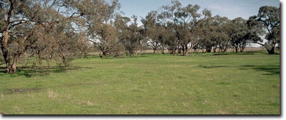 MP34 Landscape. |
Soil Profile Morphology:
Surface Soil
| A1 | 0-10 cm | Brown (7.5YR4/4); light clay (fine sandy); surface cracking when dry; moderate coarse subangular blocky, parting to medium subangular blocky structure; rough fabric; weak consistence moist and very friable; pH 8.1; clear change to: | 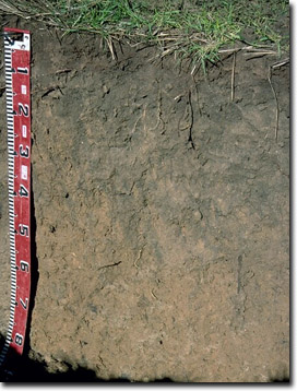 MP34 Profile |
| Subsoil | |||
| B21 | 10-20 cm | Brown (10YR4/3); medium clay; moderate medium sub-angular blocky, parting to fine sub-angular blocky structure; very weak consistence moist and friable; moderately calcareous; pH 8.6; wavy change to: | |
| B22 | 20-45 cm | Brown (10YR4/3); light medium clay; strong medium sub-angular blocky structure; smooth fabric; very weak consistence moist and very friable; slightly calcareous; pH 9.0; gradual change to: | |
| B23 | 45-90 cm | Strong brown (7.5YR5/6); light medium clay; strong very coarse prismatic, parting to strong coarse angular blocky structure; strong consistence dry; contains very few (2%) hard carbonate/silica nodules (size 6-8 mm) and few (2-5%) fine-earth carbonates; highly calcareous; pH 9.4: | |
| B24 | 90+ cm | Strong brown (7.5YR5/6); heavy clay; strong fine lenticular structure; smooth fabric; slickensides present; also contains carbonate/silica nodules (size 6-8 mm); pH 9.4. | |
NOTE: Sand along cracks throughout the profile.
Key Profile Features:
- Surface cracking in summer.
- Vertic properties i.e. slickensides and lenticular peds.
Soil Profile Characteristics:
Horizon | Horizon Depth (cm) | pH (water) | pH (CaCl2) | EC 1:5 | NaCI % | Exchangeable Cations | Field Capacity pF 2.5 | Coarse Sand (0.2 - 2.0 mm) | Fine Sand (0.02 -0.2 mm) | Silt (0.002 -0.02 mm) | Clay (<0.002 mm) | |||
Ca | Mg | K | Na | |||||||||||
meq/100g | ||||||||||||||
A1 | 0-10 | 8.1 | 7.4 | 0.13 | 12 | 4.1 | 2.2 | 0.4 | 12 | 15 | 41 | 7 | 37 | |
B21 | 10-20 | 8.6 | 7.9 | 0.17 | 19 | 7.7 | 2.6 | 0.9 | 18 | 13 | 25 | 8 | 56 | |
B22 | 20-45 | 9 | 8.2 | 0.2 | 14 | 12 | 1.8 | 1.9 | 20 | 10 | 21 | 7 | 60 | |
B23 | 45-90 | 9.4 | 8.7 | 0.62 | 0.07 | 4.8 | 15 | 1.3 | 5.9 | 21 | 8 | 23 | 9 | 57 |
B24 | 90+ | 9.4 | 8.9 | 1 | 0.16 | 3.7 | 15 | 1.4 | 8.5 | |||||
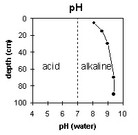 | 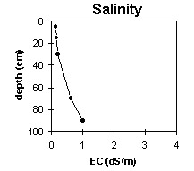 |
The surface soil is moderately alkaline. The upper subsoil is strongly alkaline and the deeper subsoil becomes very strongly alkaline. | The salinity rating is low for the upper part of the soil profile but becomes medium at 45 cm depth and high at 90 cm depth. |
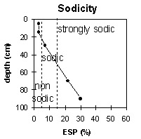 | 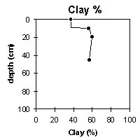 |
The surface soil and upper subsoil is non-sodic. The deeper subsoil (from 45 cm depth) is strongly sodic. | The soil profile is clayey throughout. |
Landholder Comments: Never been cultivated, floods occasionally.
Profile Described By: Mark Imhof and Nathalie Baxter (August, 1996).
© State of Victoria (Agriculture Victoria) 1996 - 2025.

This work, Victorian Resources Online, is licensed under a Creative Commons Attribution 4.0 licence. You are free to re-use the work under that licence, on the condition that you credit the State of Victoria (Agriculture Victoria) as author, indicate if changes were made and comply with the other licence terms.
The licence does not apply to ‘branding’ or some ‘images or photographs’ that may be owned by third parties. We ask you to seek prior approval to use images using the VRO feedback form. Access to higher quality images can also be provided on request.
This page was last updated on 23/03/2020.